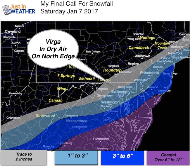
 Saturday January 7 – Tracking the snow this morning entering the Mid Atlantic and as clear picture is setting up for the heavy bands and the back edge. Both part of Maryland. The best way to look at this event is to compare to Friday morning’s snow. Places that got under one inch in metro Baltimore should get one inch or more today. But a fine line is setting up for the cut off on the northwest side. A Winter Storm Warning has been expanded to Calvert County with the 3 to 6 inch snow potential… fitting my map from last night. The only adjustment is the north end. Much of Delmarva is in for a snowy day with plenty of stickage as temps stay in the 20s. Salisbury and the beaches are still in the 6 to 12 inch range. FITF
- All Day Event From Bay To Coast
- Ending Early Afternoon on Edge Around Beltways/I-95
Below is the latest radar simulation, wind chill, high temps, and Final Call For Snowfall Map. I’ve highlighted where I see the steady and heavy snow with a white arrow, and the back edge of the steady snow with a yellow arrow. This is where dry air will make a sharp cut off. Virga may be seen much of the morning where snow appears on radar but the dry air eats up the flakes before they reach the ground.
Radar Simulation —> slider HRRR Model
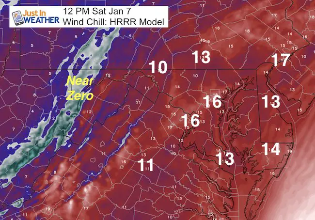
Wind Chills
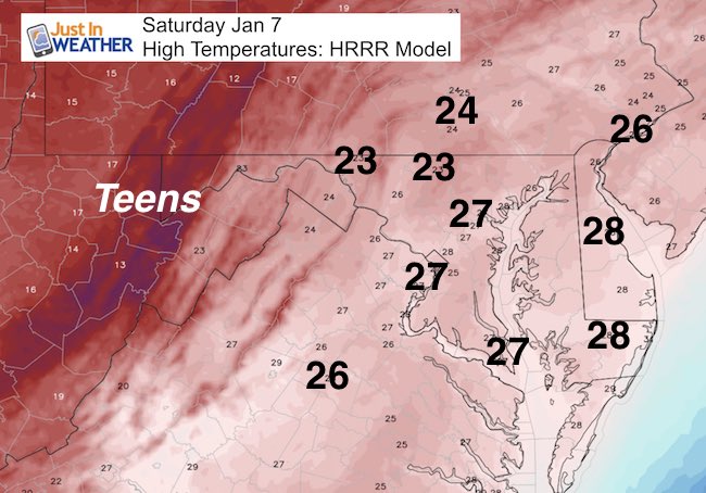
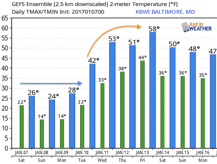
High Temperatures
Snow Totals
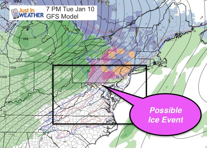
Outlook: Ice Event?
This looks like a north side deal… But two things to consider with long range events that may conflict each other.
First, there has been a trend north with systems verifying. = Warmer
Second, Snowpack from today’s event will help to hold coder air in place longer. = Colder
Temperatures: Warming Next Week, But More Winter Will Follow
Faith in the Beach Flakes
Faith in the Flakes Online- Flannel PJs Printed Inside Out
Store Now Open

- We’ve added Flannel PJ Pants that will be printed inside out. They have to be, to make it snow ?
- Free Personal Delivery for orders of 20 items or more to schools and businesses.
- Click this image for the online store.
- Look for more items to be added soon.
- Also see the info for the STEM Assembly Spirit Wear program: Put your school name on the shirts and raise money for you PTO/PTA in the process.
FITF SNOW STICKS
 Available in 2 Ft, 30 Inches, and 3 Ft Sizes. Also with Orange/Black or Purple/Black. Click on the image to see the options offered by my friend Thatcher at Signs By Tomorrow in Timonium.
Go to http://www.signsbytomorrow.com/timonium/ to order yours today! Click the ‘Request a Quote’ button at the top of the page. In comment box include color, size and payment information. Please indicate whether you’d like to have us UPS ship them to you or if you would like to pick up in our store. Snow Sticks will ship or will be ready for pick up in our store 48 hrs after order is placed, Mon-Fri.
Please share your thoughts, best weather pics/video, or just keep in touch via social media
- Facebook: Justin Berk, Meteorologist
- Twitter: @JustinWeather
- Instagram: justinweather
 Get the award winning Kid Weather App I made with my oldest son and support our love for science, weather, and technology. Our 3 year anniversary of the release and our contribution to STEM education is this November. It has been downloaded in 60 countries, and works in both temperature scales. With your support we can expand on the fun introduction to science and real weather.
Sign up for email updates on new posts
Since you may miss some posts via social media, click here for email alerts as a way to make sure you don’t miss any. *You may have to refresh that page once for your browser to clear out the images.
Also See:
My Winter Outlook for 2016-2017: Colder with snow spread out more
NOAA Winter Outlook for 2016 to 2017
La Nina Formed: What it could mean to our winter
Farmers Almanacs Split On Cold And Snow
Extreme Weather of 2015 balanced out on both ends
Low Snow Winters In Baltimore: Records Might Surprise You
NOAA Ranks Blizzard 2016 4th Worst Snowstorm On Record
Blizzard 2016 Record Top Snowstorm: Area Totals