 Thursday Jan 5 10 PM – This is a quick update on the second system on the way Friday night into Saturday morning. Only brief notes because there were many questions, but it is snowing now and I need to wake up early for my clients… But will there be more work this weekend? Over the past two days I have pointed out that I think the models will bring that second stronger storm farther north. This was based on an earlier arrival timing the energy before the jet stream could slip too far south. Also, a bias in the models that have had the storms verify farther north than projected.
UPDATE: Friday Morning
Winter Storm Warning for southern Maryland. See the latest projected totals and what to watch for should it shift farther north.
This storm has Winter Storm Watches as far south as Atlanta and into Delmarva. Ocean City, MD to eastern North Carolina could see 6 to 12 inches of snow. But a sharp cut off leaves central Maryland dry… Or does it?
Here are two maps form the GFS and Canadian models I showed this morning with the bias accounted for.. So I drew in where I expected the back edge of the snow to be….
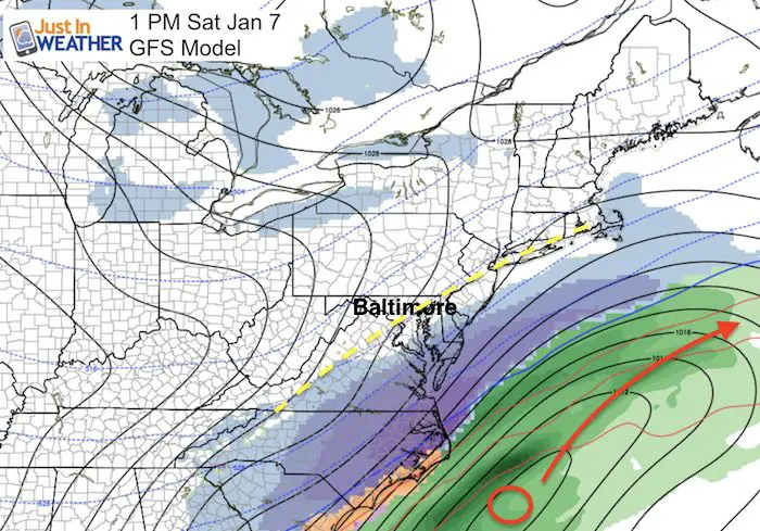
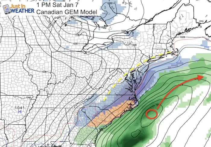
Here’s the set up tonight:
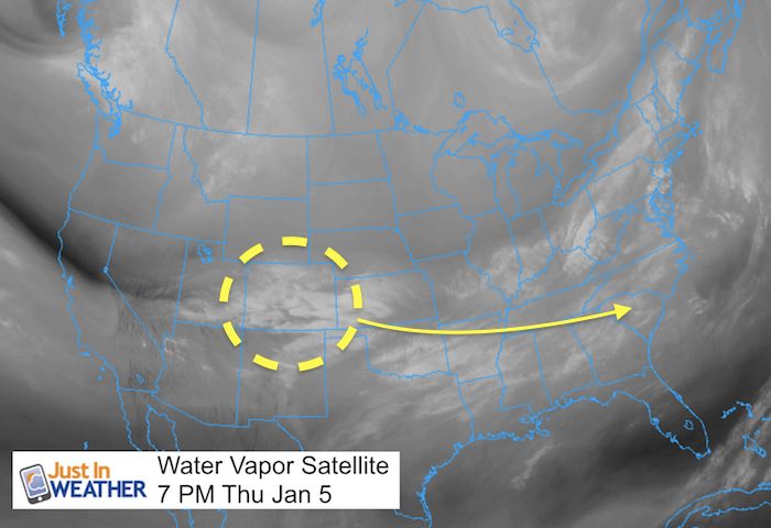
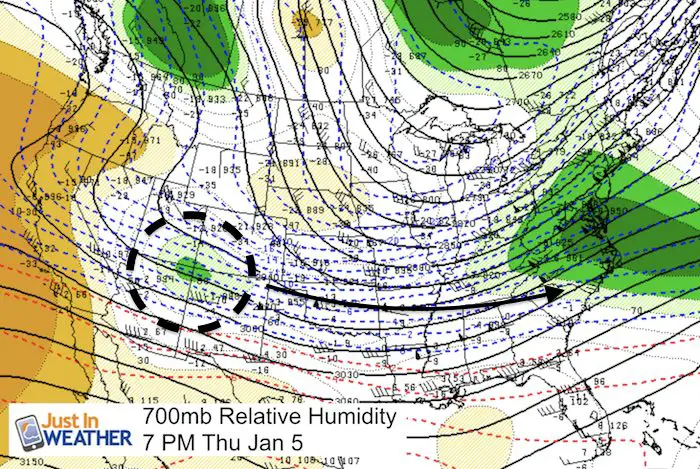
Upper Level Winds
These will carry this system as a southern storm. The expectation on many models has been for the momentum to swing it off the coast before a chance to turn north…
The latest NAM Model —> slider
This did shift the storm far enough north to show snow for most of Delmarva and back up near I-95
I do not like to bank on one model shift… but the trend has been closer to keep places around the Chesapeake Bay in check.
The latest GFS Model did show that slight shift closer… ever so slight.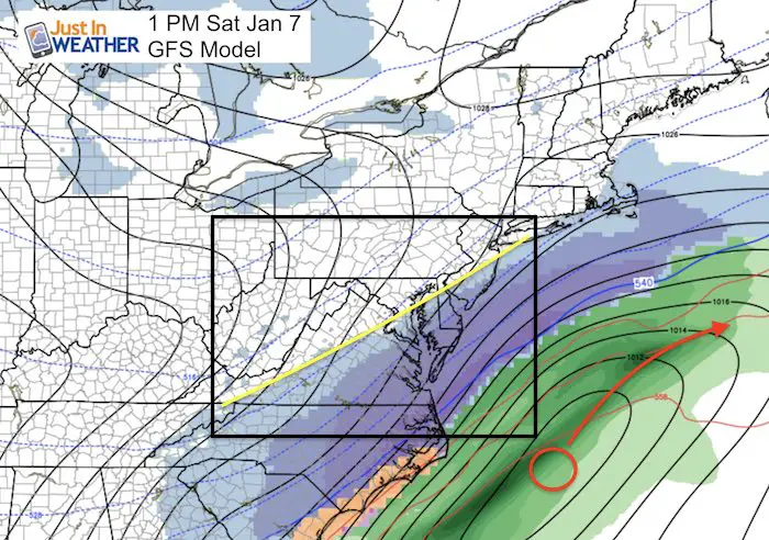
Will we get snow? This all hinges on how the current system behaves. Not only howe much snow it drops, and how soon it departs… but what it does to our north. This will help dictate the jet stream. Perhaps limit the drop south and allow the next system to stay closer rather than be shoved farther away.
I will update this in the morning…. But for now, Salisbury, Ocean City, and Dover all could have decent snow Saturday morning. Virginia Beach may end up with nearly a foot of snow! That’s a rarity!
Faith in the Beach Flakes
Faith in the Flakes Online- Flannel PJs Printed Inside Out
Store Now Open

- We’ve added Flannel PJ Pants that will be printed inside out. They have to be, to make it snow ?
- Free Personal Delivery for orders of 20 items or more to schools and businesses.
- Click this image for the online store.
- Look for more items to be added soon.
- Also see the info for the STEM Assembly Spirit Wear program: Put your school name on the shirts and raise money for you PTO/PTA in the process.
FITF SNOW STICKS
 Available in 2 Ft, 30 Inches, and 3 Ft Sizes. Also with Orange/Black or Purple/Black. Click on the image to see the options offered by my friend Thatcher at Signs By Tomorrow in Timonium.
Go to http://www.signsbytomorrow.com/timonium/ to order yours today! Click the ‘Request a Quote’ button at the top of the page. In comment box include color, size and payment information. Please indicate whether you’d like to have us UPS ship them to you or if you would like to pick up in our store. Snow Sticks will ship or will be ready for pick up in our store 48 hrs after order is placed, Mon-Fri.
Please share your thoughts, best weather pics/video, or just keep in touch via social media
- Facebook: Justin Berk, Meteorologist
- Twitter: @JustinWeather
- Instagram: justinweather
 Get the award winning Kid Weather App I made with my oldest son and support our love for science, weather, and technology. Our 3 year anniversary of the release and our contribution to STEM education is this November. It has been downloaded in 60 countries, and works in both temperature scales. With your support we can expand on the fun introduction to science and real weather.
Sign up for email updates on new posts
Since you may miss some posts via social media, click here for email alerts as a way to make sure you don’t miss any. *You may have to refresh that page once for your browser to clear out the images.
Also See:
My Winter Outlook for 2016-2017: Colder with snow spread out more
NOAA Winter Outlook for 2016 to 2017
La Nina Formed: What it could mean to our winter
Farmers Almanacs Split On Cold And Snow
Extreme Weather of 2015 balanced out on both ends
Low Snow Winters In Baltimore: Records Might Surprise You
NOAA Ranks Blizzard 2016 4th Worst Snowstorm On Record
Blizzard 2016 Record Top Snowstorm: Area Totals