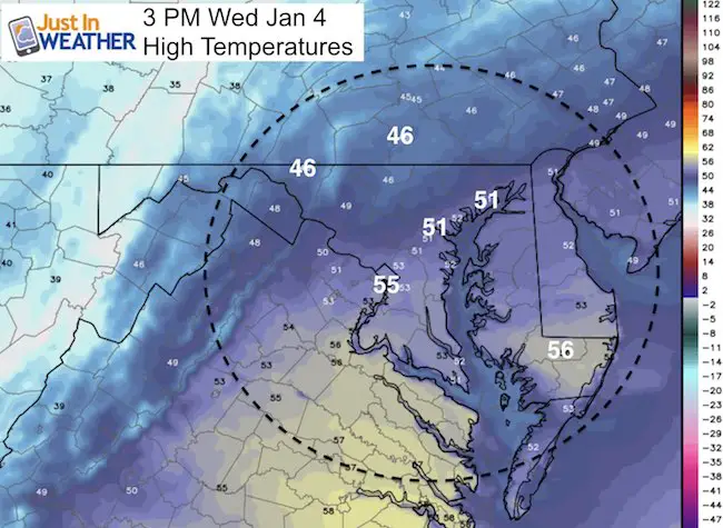
Wednesday January 4 – The roads are damp this morning, but the fog is starting to disperse and will get some help from increasing wind. As the winds increase, first the clouds will break and temps will warm through lunch time. Then the colder air will spill in during the afternoon and we can set our sights on a quick moving snow maker for Thursday night. At this point the snow looks to be light, but cold enough for stickage and timing out to impact the Friday morning commute. This could impact schools… and our entire region from northern Virginia through most of Maryland, and southern Pennsylvania are worth watching. Even Delaware! Maps and more below:
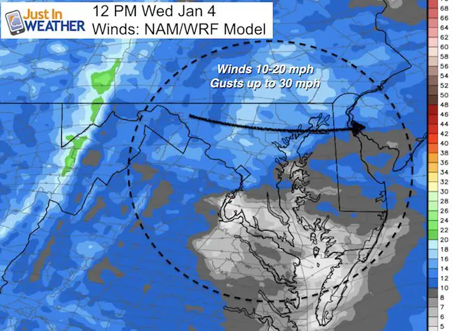
Today: Winds will become gusty and high temperatures will be mild peaking just after the lunch hour
Baltimore Numbers For January 4
- Average High 42°F
- Record High 70°F in 2000
Snow On The Way
The first flakes will arrive Thursday evening. Metro Baltimore should get it between 7 PM and Midnight… Ending around daybreak Friday
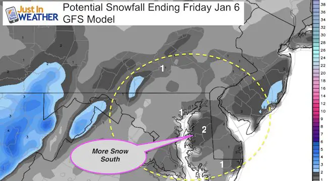
GFS Model —> slider
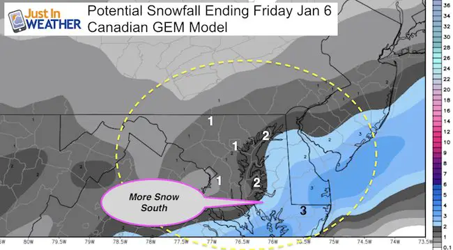
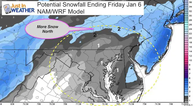
Snowfall Potential Maps
These are computer model projections. Note the difference in the band of heavier snow. While the range is from a dusting to 2 inches for most of us, the I will post my first call for snowfall map later today… The Canadian Model shows up to 3 inches on Delmarva, while the NAM/WRF model has more north in central PA. This may shed light on any model errors for the next storm on Saturday.
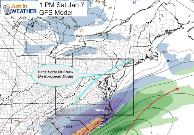
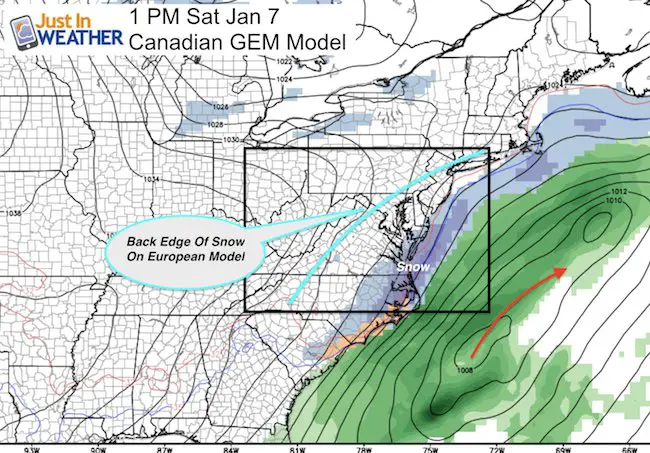
Weekend Storm?
The energy entering the west coast now will one racing along a strong jet that will be shifting to our south. At this point, both the GFS and Canadian Model show snow Saturday for the southern Delmarva, VA Beach, and OBX. But the European Model (overlaid for comparison) shows the back edge of the snow north into Baltimore. Slight fluctuation in timing of the energy and location of the jet stream can result in an adjustment of this track by 100 miles or more. So this is still not set in stone. I have noticed a model bias, with systems verifying a little farther north. So at this point, I have to suggest the European model is stronger with snow more likely reaching parts of central Maryland. stay tuned…
Faith in the Flakes Online- Flannel PJs Printed Inside Out
Store Now Open

- We’ve added Flannel PJ Pants that will be printed inside out. They have to be, to make it snow ?
- Free Personal Delivery for orders of 20 items or more to schools and businesses.
- Click this image for the online store.
- Look for more items to be added soon.
- Also see the info for the STEM Assembly Spirit Wear program: Put your school name on the shirts and raise money for you PTO/PTA in the process.
FITF SNOW STICKS
 Available in 2 Ft, 30 Inches, and 3 Ft Sizes. Also with Orange/Black or Purple/Black. Click on the image to see the options offered by my friend Thatcher at Signs By Tomorrow in Timonium.
Go to http://www.signsbytomorrow.com/timonium/ to order yours today! Click the ‘Request a Quote’ button at the top of the page. In comment box include color, size and payment information. Please indicate whether you’d like to have us UPS ship them to you or if you would like to pick up in our store. Snow Sticks will ship or will be ready for pick up in our store 48 hrs after order is placed, Mon-Fri.
Please share your thoughts, best weather pics/video, or just keep in touch via social media
- Facebook: Justin Berk, Meteorologist
- Twitter: @JustinWeather
- Instagram: justinweather
 Get the award winning Kid Weather App I made with my oldest son and support our love for science, weather, and technology. Our 3 year anniversary of the release and our contribution to STEM education is this November. It has been downloaded in 60 countries, and works in both temperature scales. With your support we can expand on the fun introduction to science and real weather.
Sign up for email updates on new posts
Since you may miss some posts via social media, click here for email alerts as a way to make sure you don’t miss any. *You may have to refresh that page once for your browser to clear out the images.
Also See:
My Winter Outlook for 2016-2017: Colder with snow spread out more
NOAA Winter Outlook for 2016 to 2017
La Nina Formed: What it could mean to our winter
Farmers Almanacs Split On Cold And Snow
Extreme Weather of 2015 balanced out on both ends
Low Snow Winters In Baltimore: Records Might Surprise You