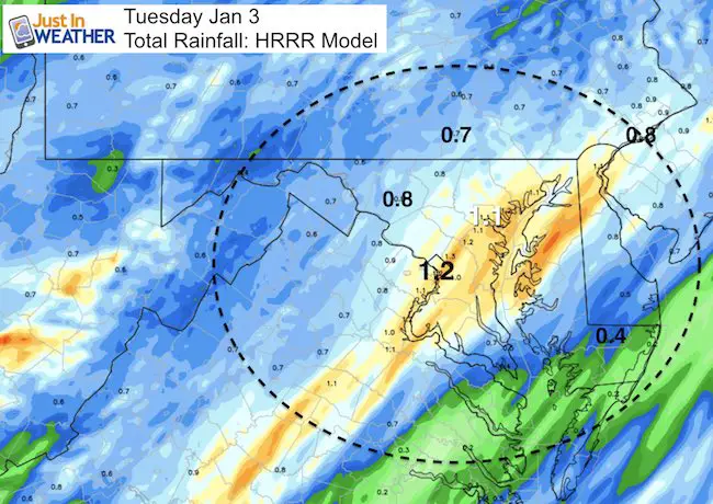
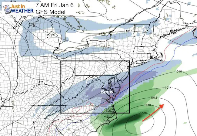
 Tuesday January 3 – Today will be a slow return back to a normal schedule for the new year. Wet roads and fog will give way to periods of heavy rain that appear to be focused right along the I-95 corridor. The first wave will arrive just after sunrise during the commute, and the second push will be around lunchtime. Totals could push one inch or more or needed rain as we still have a deficit since December 1 of about 1/3 inch, and for last year… The rain will settle down this evening. Behind this storm, colder air will spill in and energy in the jet stream will help light snow develop Thursday night into Friday. This could bring the first dusting to one inch for many… with a second storm to follow on Saturday. Both ‘appear’ to have the focus south and east of Baltimore, which includes Delmarva/Ocean City, and southeast Virginia. See the maps, my thoughts, and notes below.
Radar Simulation: —> slider HRRR Model
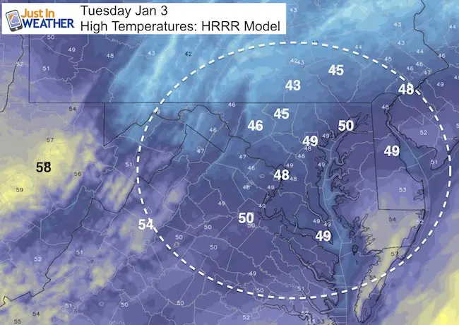
High Temperatures (well above freezing)
Tracking the next two events
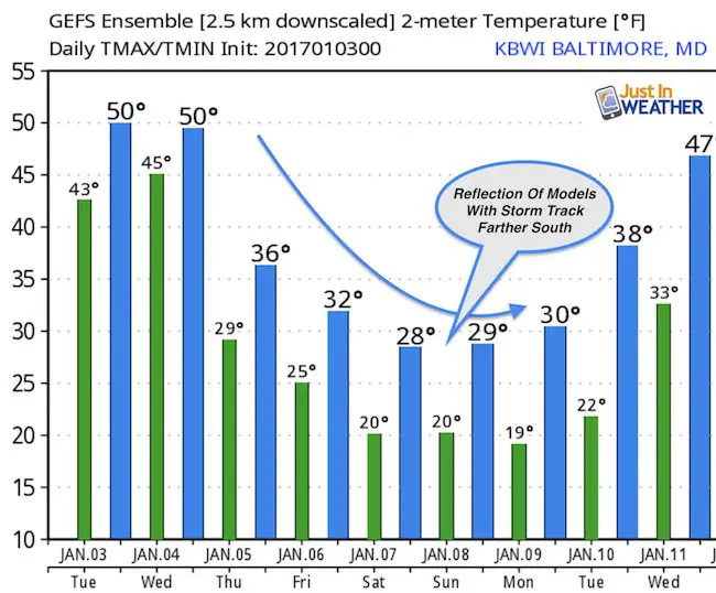
I want to point out the last two recent Freezing Rain Advisories issued for northern Maryland had which did not materialize. The trend has been to push systems farther north, which is why I think this weekend event is still in play. This is NOT my wish casting, but rather a modeling error with a Pacific dominated jet stream. I do not want to put much weight in the specifics today since there are still many variables. Each model run looks so different… The temperature outlook reflects the models that keep the storm farther south, making us colder. So the precise track of the jet stream is still left to be determined, and why the impact for us is still uncertain.
—-> slider
The Canadian Model has been most consistent and reliable this winter, which is why I am showing it here. Note the light snow, but darker blue shows moderate snow for both events on the Delmarva
[metaslider id=41959]
GFS Model
This model has a track farther south, but the error to the north should be considered.
Friday Morning
Saturday Evening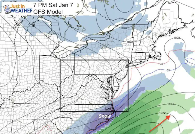
Sign up for email updates on new posts
Since you may miss some posts via social media, click here for email alerts as a way to make sure you don’t miss any. *You may have to refresh that page once for your browser to clear out the images.
Temperature Outlook
Faith in the Flakes Online- Flannel PJs Printed Inside Out
Store Now Open

- We’ve added Flannel PJ Pants that will be printed inside out. They have to be, to make it snow ?
- Free Personal Delivery for orders of 20 items or more to schools and businesses.
- Click this image for the online store.
- Look for more items to be added soon.
- Also see the info for the STEM Assembly Spirit Wear program: Put your school name on the shirts and raise money for you PTO/PTA in the process.
FITF SNOW STICKS
 Available in 2 Ft, 30 Inches, and 3 Ft Sizes. Also with Orange/Black or Purple/Black. Click on the image to see the options offered by my friend Thatcher at Signs By Tomorrow in Timonium.
Go to http://www.signsbytomorrow.com/timonium/ to order yours today! Click the ‘Request a Quote’ button at the top of the page. In comment box include color, size and payment information. Please indicate whether you’d like to have us UPS ship them to you or if you would like to pick up in our store. Snow Sticks will ship or will be ready for pick up in our store 48 hrs after order is placed, Mon-Fri.
Please share your thoughts, best weather pics/video, or just keep in touch via social media
- Facebook: Justin Berk, Meteorologist
- Twitter: @JustinWeather
- Instagram: justinweather
 Get the award winning Kid Weather App I made with my oldest son and support our love for science, weather, and technology. Our 3 year anniversary of the release and our contribution to STEM education is this November. It has been downloaded in 60 countries, and works in both temperature scales. With your support we can expand on the fun introduction to science and real weather.
Also See:
My Winter Outlook for 2016-2017: Colder with snow spread out more
NOAA Winter Outlook for 2016 to 2017
La Nina Formed: What it could mean to our winter
Farmers Almanacs Split On Cold And Snow
Extreme Weather of 2015 balanced out on both ends
Low Snow Winters In Baltimore: Records Might Surprise You
NOAA Ranks Blizzard 2016 4th Worst Snowstorm On Record
Blizzard 2016 Record Top Snowstorm: Area Totals