Long Wave Cycles are global scale weather patterns. These are observed higher in the atmosphere at jet stream level. They last longer periods of time, and can produce the ‘trends’ in the weather we see at the surface.
Here is a brief look at the Polar Vortex, Arctic Oscillation, North Atlantic Oscillation, and ENSO (El Nino/Southern Oscillation).
Long Range Pattern Forecasts
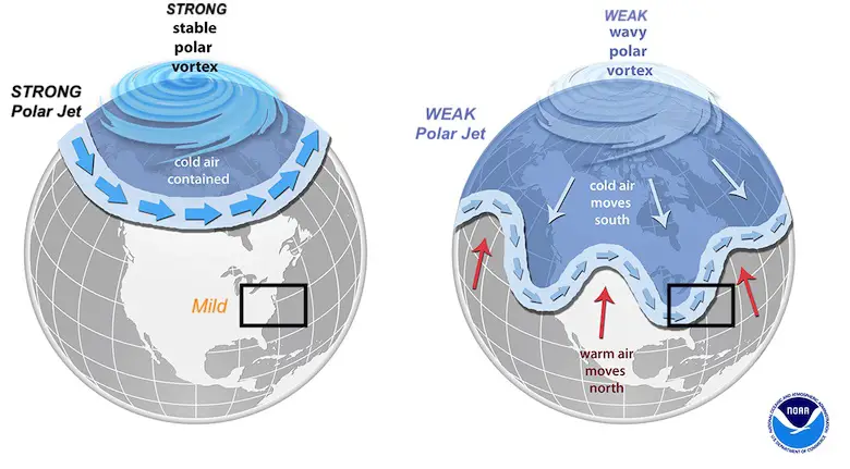
Polar Vortex
Northern Hemisphere: 500mb Past 30 days

The Polar Vortex is a naturally occurring flow of air around the North Pole.
In normal conditions, the coldest air is locked up within it. But a weak Polar Vortex can be disrupted to wobble or split, allowing arctic air to spill southward into North America, Europe, and Asia.
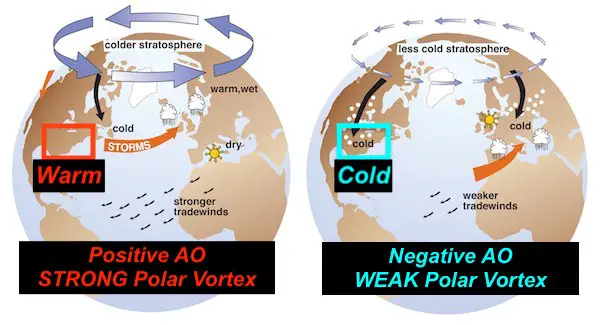
Arctic Oscillation

The Arctic Oscillation is an index in essence connected to the normal easterly winds in the higher latitudes.
When they weaken or reverse, a NEGATIVE index would be measured. This would allow colder air to spill southward.
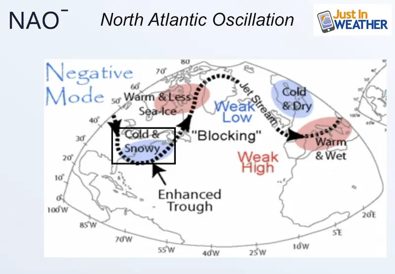
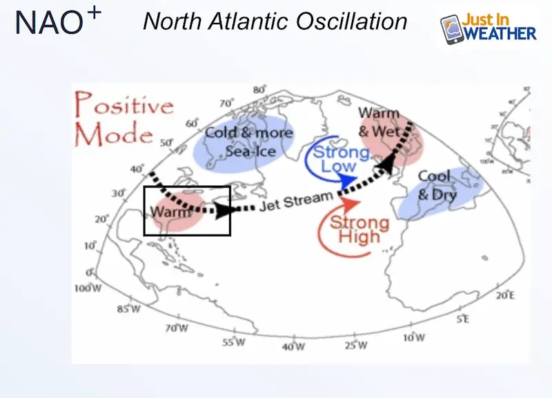
North Atlantic Oscillation

North Atlantic Oscillation is a measure of the slow or blocking of winds in the North Atlantic.
When a Block develops, often in Greenland, then arctic air has a better chance to reach the eastern US.
This also disrupts the jet stream to produce more frequent and perhaps stronger coastal storms.

Global 200 mb Past 30 Days

Global circulation can often be seen as waves of ridges and troughs. We measure them aloft at constant pressure levels to see how the height changes.
This 200mb level is located roughly 39,000 Feet above the ground.
- Ridges are seen in Orange/Red.
- Troughs are seen in Blue
El Nino/Southern Oscillation
Animations
Sea Surface Temperatures (SST)

Sea Surface Temperatures are obtained from remote buoys and satellite measurements.
SST Anomalies

Anomalies are a comparison of measurements to a 30 year average.
This is valuable in determining warming or cooling trends, that can identify an El Nino or La Nina.
Sea Surface Temperature Anomalies

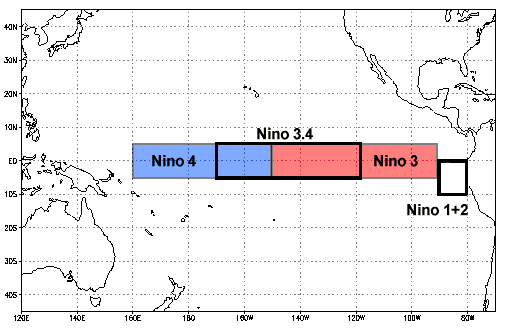
The tropical Pacific is broken down into regions. Compare the numbered plots to the locations in this map.
Sea Surface Temperature Forecast
Standardized Anomaly
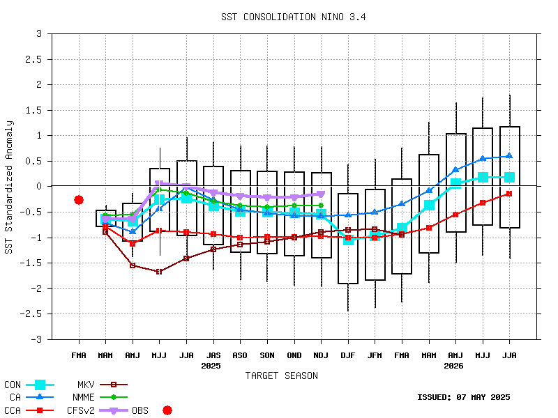
Forecast
Temperature Forecast
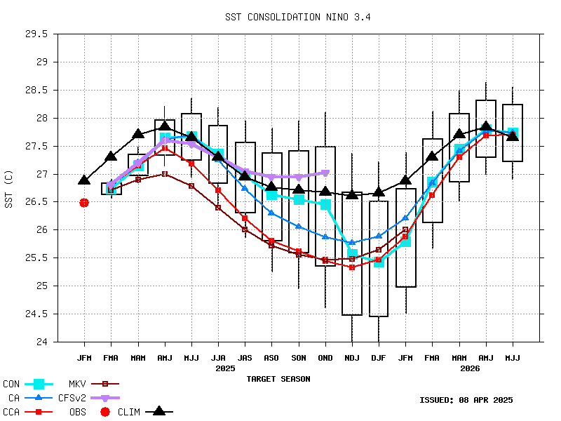
Forecast
Historical Chart: Cold (La Nina) and Warm (El Nino) Episodes

Your Content Goes Here
MJO – Madden/Jullian Oscillation
From NOAA:
MJO is an eastward moving disturbance of clouds, rainfall, winds, and pressure that traverses the planet in the tropics and returns to its initial starting point in 30 to 60 days, on average. This atmospheric disturbance is distinct from ENSO, which once established, is associated with persistent features that last several seasons or longer over the Pacific Ocean basin. There can be multiple MJO events within a season, and so the MJO is best described as intraseasonal tropical climate variability (i.e. varies on a week-to-week basis).
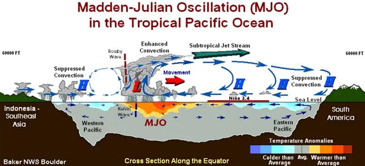
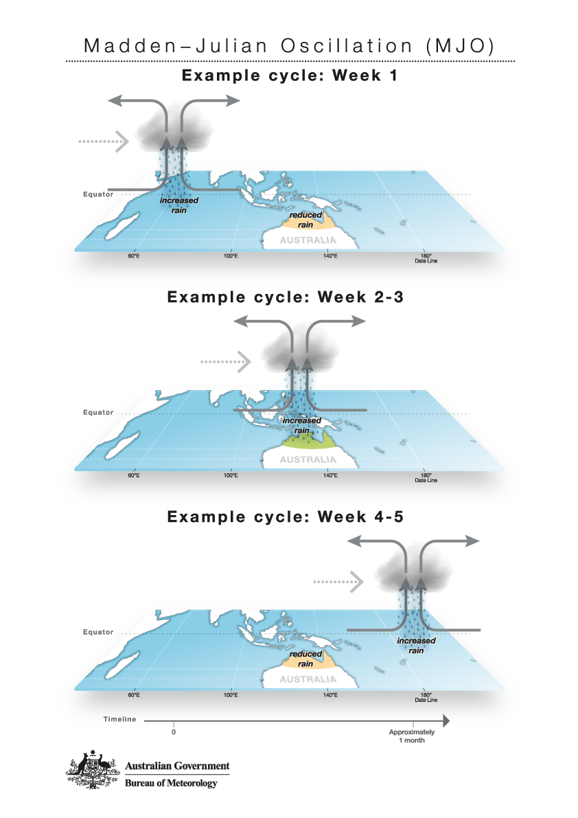
The MJO consists of two parts, or phases: one is the enhanced rainfall (or convective) phase and the other is the suppressed rainfall phase. Strong MJO activity often dissects the planet into halves: one half within the enhanced convective phase and the other half in the suppressed convective phase. These two phases produce opposite changes in clouds and rainfall and this entire dipole (i.e., having two main opposing centers of action) propagates eastward. The location of the convective phases are often grouped into geographically based stages that climate scientists number 1-8.
HiRes GFS
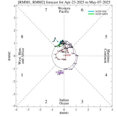
Regions 7, 8, and 1 are historically more favorable to feed a storm track to the west coast of the US. Sometimes coordinating for east coast storms as well.
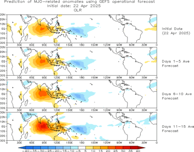
GEFS OLR Map
Forecast
See More Forecasts
All Winter Weather Resource Pages
Recent Articles
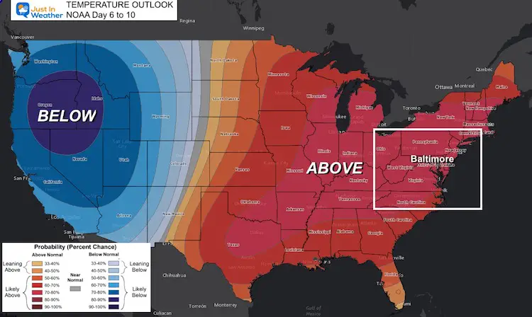
Temperature Outlook Above Normal Through Mid October
October 5 2021 What happened that that Fall weather? Well,
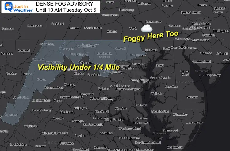
October 5 Dense Fog Advisory Then Tracking More Showers Later
Tuesday October 5 A few rounds of showers and thunderstorms
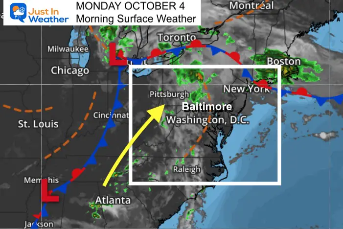
October 4 Still Warm And A Few Days With Showers This Week
Monday October 4 After summer heat and an onslaught of
Please share your thoughts, best weather pics/video, or just keep in touch via social media
Facebook: Justin Berk, Meteorologist
Twitter: @JustinWeather
Instagram: justinweather
Winter Outlook Series


14 Local Maryland Pages (and York PA)
We have made a page for Maryland Weather which gives you the current conditions for 14 present area locations.

FITF Shop Open
My ‘bonus’ daughter Jaiden and wife showing off our popular Maryland Hoodies. Unisex and women’s items all produced in Maryland.
Click here to see this and many other new items.


Also see:
Maryland Weather Page
I wanted to keep it simple. Just the basics for a quick view at any time.

Just In Power Kids:
A portion of proceeds go to our programs Providing FREE holistic care for kids in cancer treatment and up to 5 years post treatment and caregivers.
![]()
New Caps and Hats

