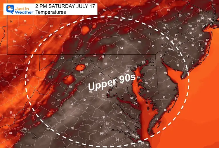
Saturday July 17 2021
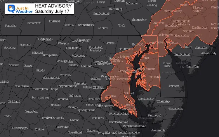
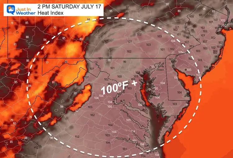
Today is the last day of the current heat wave, and it is going to go out with a bang. Yesterday, Baltimore hit 98ºF and we may match it today. But the Heat Index will be 105ºF+.
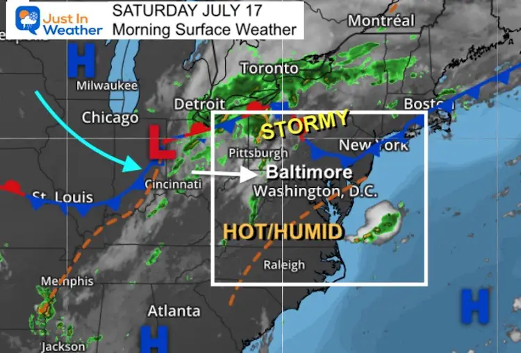
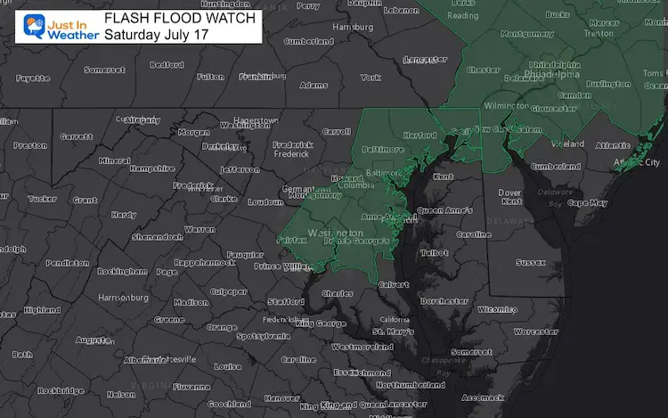
Storms will erupt this afternoon through evening. There is a risk they turn severe. With ample moisture AND some slow movers, rainfall could push 2”/hour rates. As a result a Flash Flood Watch is in place as well.
See the radar simulation below for most likely timing in your location as this develops in the mountains at lunchtime, and reaches the beaches by midnight.
Morning Surface Weather
The heat dome will be forced out with a strong cold front. The timing aligning with the peak heat of the day will maximize the storm potential.
Weather Alerts Today
Heat Advisory: Where Index Values = 105ºF+
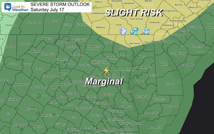
Severe Storm Outlook
- Primarily Damaging Wind Over 60 mph, slight risk for large hail and isolated tornadoes.
- Marginal Risk= There will be storms, but a lower chance they turn ‘severe’.
Note: This product is from NOAA and with recent events has underestimated the coverage of the worst weather. As you will see with the radar simulation below, there will be a line of storms in central and southern Maryland that looks intense. I expect the ‘marginal’ region is also worth paying attention to.
Flash Flood Watch: 2 PM to 2 AM Sunday
Rainfall rates may exceed 2 inches per hour
Radar Simulation —> slider
- Storms will develop in the mountains at lunchtime.
- Metro areas: Timing mid afternoon through dinner time.
- Delmarva and Beaches: Storm time evening through midnight.
Reminder: This product helps with timing, but I have seen storms erupting an hour or so earlier with recent events. The coverage has also been under-represented. We may see more storms than shown here.


Weather Almanac: Climate Data
TODAY July 17
Normal Low in Baltimore: 67ºF
Record 58ºF in 1987
Normal High in Baltimore: 88ºF
Record 101º F 1988
Afternoon Temperature Forecast
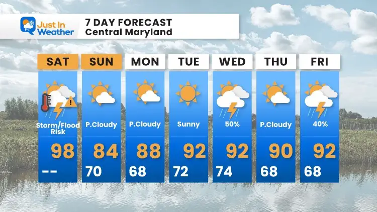
7 Day Forecast
Maryland Trek 8 Begins on August 8
329 Miles From Wisp To Ocean City
To Honor Kids In Cancer Treatment and Support FREE Programs At Just In Power Kids
![]()
Still Time To Sponsor Our Team
Keep our expenses low.
Click Here to Help with Lodging, Meals, and Fuel

Sunshine State Of Mind
I am done with the cold and snow (for the season). I am embracing my wife’s mantra of Sunshine State of Mind.
This was designed by Shannon Berk and we will be wearing it through spring and to the beach.
Double Benefit: Proceeds will be split between our nonprofit Just In Power Kids and the development of my new weather website. That has been scheduled to be ready to launch in May.

14 Local Maryland Pages (and York PA)
We have made a page for Maryland Weather which gives you the current conditions for 14 present area locations.

Please share your thoughts, best weather pics/video, or just keep in touch via social media