Monday February 15 2021 Evening Update
The active winter pattern is currently producing historic snow and cold from south Texas to the Ohio Valley. The arctic air went due south to the Mexico boarder, but has been having trouble moving was to the mountains.
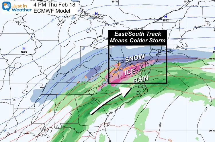
The prime reason has been the strong and active storm track. Tonight we are on the milder side of it, but the next event will be colder. It is expected to begin with snow and ice for us on Thursday. That part we have already been talking about. What is new is that the blanket of snow from the current storm may help this next one shift east and south, resulting an even colder result for us.
Thursday Storm Snapshot
I had mentioned that snow pack can help refrigerate the atmosphere and shift storm tracks. The computer model is just starting to pick up on that. In fact, the European Model has been the leading the charge as the colder model for our next storm.
In my last report I showed that the GFS model has trended in that direction. Now the European continues to lead the charge even colder.
Why is that important?
Because instead of snow to ice to rain, it is possible more of our region remains frozen.
I want to show you something in reverse to make my points. Let’s look at temperatures first, then the storm simulation slider.
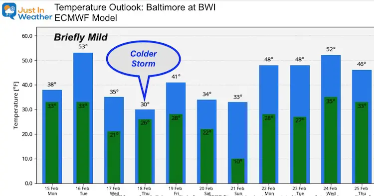
Temperature Outlook
Yes, we will have a brief warm up, but the Thursday storm day is now shown remaining below freezing for Baltimore.
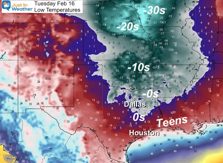
Why is this? Let’s take a look at Texas Temps on Tuesday.
Tuesday Morning
Snow covers most of Texas now! That snowpack was expanding through Louisiana, Arkansas, and Tennessee today.
Following this storm, Dallas may end up near or below zero in the morning. Teens reach to the Gulf Coast by Houston.
*This may blow some old records away by as much as 10 additional degrees (on the low end)!!!
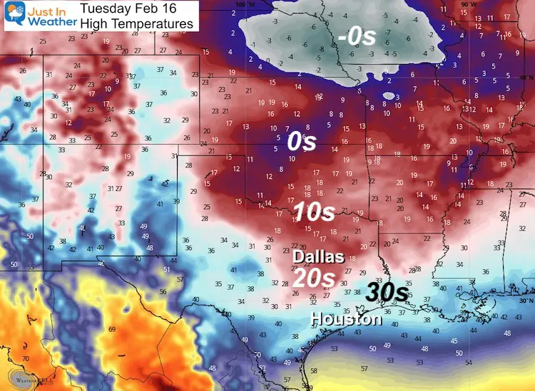
Tuesday Afternoon
The deep snow pack will be reflecting sunlight (albedo), allowing this air mass to remain very cold! This is what will feed into the back of the next storm.
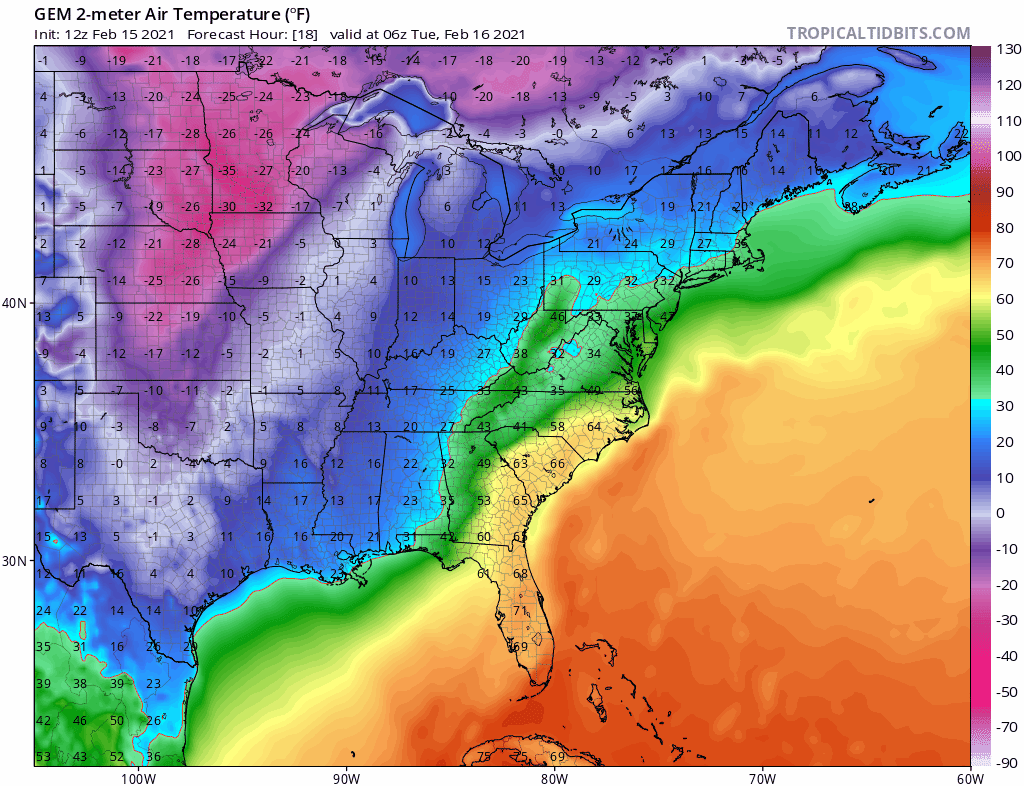
Temperature Animation (Canadian GEM)
Tacking the temperatures (through the weekend), we can see after our warm brief up Tuesday, that cold air shift east.
Models often play catch up with low level extreme cold air.
Here’s The Possible Result:
This may allow the cold side of the storm to have more force and allow the track to push farther east…
Storm Simulation ECMWF —-> slider
Notice that pink remains Thursday night into Friday morning. While there still may be ice mixing in, this solution keeps metro Baltimore below freezing. The impact then can be a harder hit into Friday with no thaw.


Compare to the GFS Model I showed earlier today.
Remember that this model has been playing catch up, lagging behind with shifting to a cooler track. This earlier plot was colder than it had been.
—-> slider
How much snow?
Plan for at least few inches early, and impact during the day. That is before any change over to ice. More snow will likely fall in our northern counties, but we need to see how tonight’s storm and cold air to follow Wednesday behaves. That will help present the storm track and extent of snow and ice.
After we get this first storm out of the way, we can start locking in on the true snowy impact for us.
Faith in the Flakes….
Please share your thoughts, best weather pics/video, or just keep in touch via social media
Facebook: Justin Berk, Meteorologist
Twitter: @JustinWeather
Instagram: justinweather
Winter Outlook Series


14 Local Maryland Pages (and York PA)
We have made a page for Maryland Weather which gives you the current conditions for 14 present area locations.


FITF Shop Open
My ‘bonus’ daughter Jaiden and wife showing off our popular Maryland Hoodies. Unisex and women’s items all produced in Maryland.
Click here to see this and many other new items.

