October 9 2020
Hurricane Delta reached Category 3 again in the Gulf of Mexico, but dropped a little speed as it approaches land. This is set to hit the same areas that Hurricane Laura devastated just 6 weeks ago. While this storm is not as strong, it is potent and hitting an already damaged infrastructure.
Hurricane Delta Update 5 PM (4 PM CDT)
Top winds were 105 mph. The hurricane force winds reach 40 mile from the center. Tropical Storm force winds reach 160 mph.
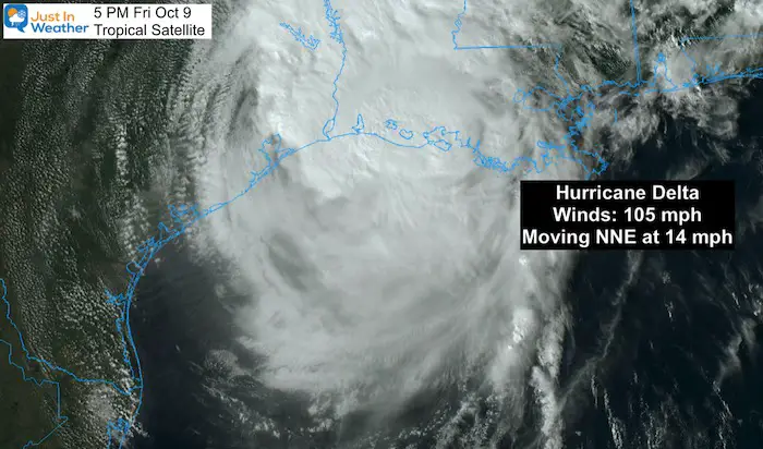
The eye of the storm, although not evident on satellite, is expected to be on land close to 7 PM. The impacts will continue inland as this is eventually downgraded to a tropical depression.
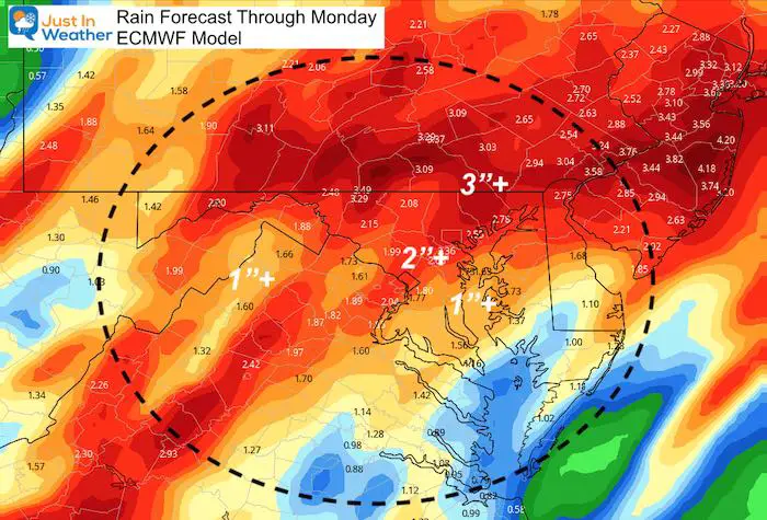
In addition to local flooding from surge and rain, heavy rain is expected to reach the Mid Atlantic by the end of the weekend.
![]()
Here is a collection of resources for you to track this storm at landfall and beyond. This includes: Satellite views, radar, waves, interactive widget, computer model plots, and National Hurricane Center maps, statements, and warnings.
Satellite Images
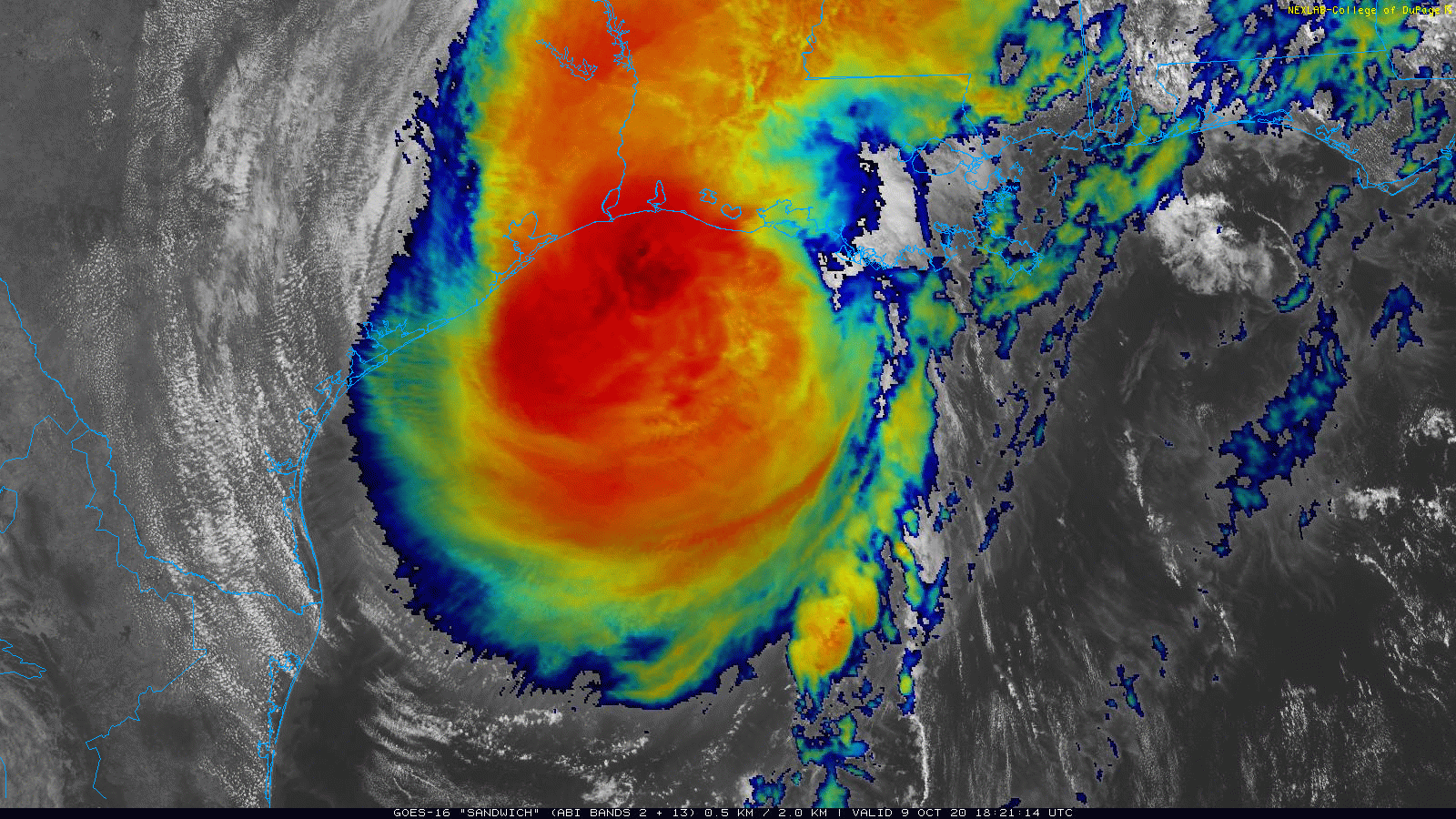
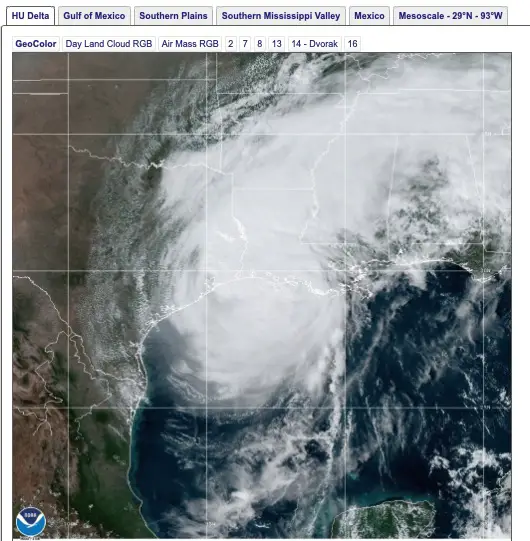
Sandwich True Color and IR Cloud Tops
See All Floater Views From GOES East and more links below
Wind and Pressure Levels
This is a forecast view. Pinch to zoom or move the map.
You can see the future-cast using the button at the bottom of the map.
Radar And Lightning
Waves
Computer Model Forecast Plots
The consensus is along the middle of the Louisiana coast, this is to the west of New Orleans, but may still carry the max impact with the stronger side to the east.

National Hurricane Center Update
This map will update with each new advisory. You can reload the page for new images at 8 PM, 11 PM, 2 AM, 5 AM, 8 AM, etc.
Latest Advisory Stats At The Bottom Of The Map

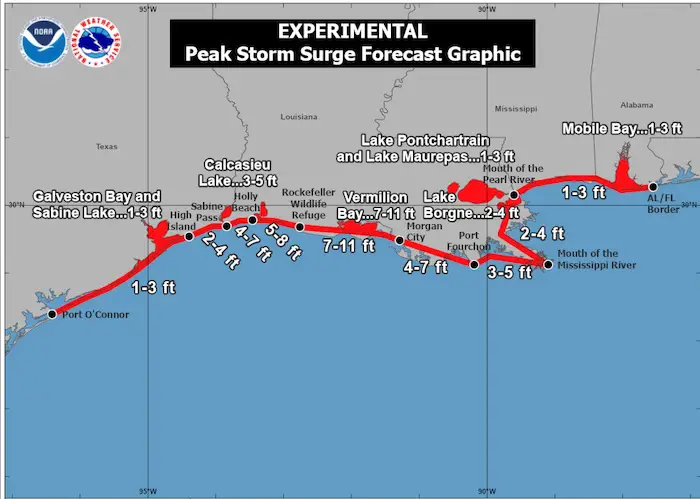
SUMMARY OF WATCHES AND WARNINGS IN EFFECT:

A Storm Surge Warning is in effect for...
* High Island Texas to the Mouth of the Pearl River including
Calcasieu Lake, Vermilion Bay, and Lake Borgne

A Hurricane Warning is in effect for...
* High Island Texas to Morgan City Louisiana

A Tropical Storm Warning is in effect for...
* West of High Island to Sargent Texas
* East of Morgan City Louisiana to the mouth of the Pearl River,
including New Orleans
* Lake Pontchartrain and Lake Maurepas
Peak Storm Surge From National Hurricane Center
Also See:
All GOES EAST Satellite ‘Floater’ views
Click here to see all new satellite loops
Related Posts
2020 Tropical Storm and Hurricane Names and Naming History

Atlantic Tropical History: Maps of Origin Regions Every 10 Days


Please share your thoughts, best weather pics/video, or just keep in touch via social media
-
Facebook: Justin Berk, Meteorologist
-
Twitter: @JustinWeather
-
Instagram: justinweather
Email Updates
Please make sure you sign up (above or click here to sign up for email alerts…. ) for my newsletter. This way you will get an email to make sure you are notified of each post.
Also See


NEW INTERACTIVE WEATHER PAGES
Maryland Weather Page
I wanted to keep it simple. Just the basics for a quick view at any time.

14 Local Maryland Pages (and York PA)
We have made a page for Maryland Weather which gives you the current conditions for 14 present area locations. Many of these match up with the spots on our route. Please use this list below are reference. I will include them daily with my articles on the kids.
Other Links:
Was Your County Not Included?
Click this map for more on the regional forecast zones

Baltimore Weather At BWI May Not Be As Hot As Reported
Construction at the airport close to the weather station may be added artificial heat. Click here or the image for the details.

Just In Power Kids:
Proceeds go to our programs Providing FREE holistic care for kids in cancer treatment and up to 5 years post treatment and caregivers.
![]()