Tuesday Evening Update February 25 2020
The second part of this weather event will be the strongest part. The developing fog tonight is a signal of the moisture in place. The cold side of the storm will get close tomorrow and bring snow to parts of Maryland. The western mountains will get a few fresh inches. But the flakes may reach parts of central Maryland and southern Pennsylvania. You just may have to wake up in the middle of the night to see them.
In between will be strong upper level winds and enough energy that could trigger marginal severe storms.
The good news and bad news is that this may all happen around midnight.

Severe Storm Risk
The Storm Prediction Center has identified our area with a ‘marginal’ risk for storms to turn severe. Marginal means the chance is low, but it is still there.

Midnight Snapshots:
The good news about this cold front and potential storm line passing metro areas around midnight, is that the temperatures will not be warm. This takes some of the energy away form the system.
The bad news is that this will be when many people are sleeping. There is potential for winds to push over 45 mph. Gusts of 58 mph is the criteria for storms to be severe.
But the parameters indicate the potential for rough weather.
K Index
A value over 30 supports thunderstorms

Helicity
The Helicity on the NAM 3 Km Model does seem a little on the high side. I’ve identified the regions where the wind flow may result in spin. Ahead of the front the winds will be flowing from the south, but the front itself will be racing in from the west.

Wind Sheer
This will be very strong with the cold front turning the winds with the cold air arriving.

Radar Simulation —> slider
Follow the yellow and orange shading for where the line of storms may pass. This is around midnight in metro areas. But the BLUE indicates the snow progressing east of the mountains. The counties west and north of Baltimore may get a brief hour or so of snow. But if you want to see it, the best chance will be between 1 and 3 AM. Also, most likely between Hagerstown, Frederick, Mt Airy, Westminster, and York PA.


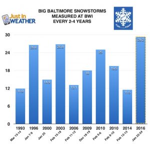
Baltimore history of snowless February(s) and winters when March brought the most snow:
Click here to see more: March Snow After Winter Has Been Slow
Please share your thoughts, best weather pics/video, or just keep in touch via social media
-
Facebook: Justin Berk, Meteorologist
-
Twitter: @JustinWeather
-
Instagram: justinweather
WEATHER WIFE COLLECTION
- Thanks to Shannon (weather wife) for hand picking items ‘she’ wants to wear
- The Yoga Pants have side leg pocket for your phone
- The Hoodie is extra soft and has the important ‘thumb holes’
Part 1: More Snow This Winter Supported By Stats
Part 2: Solar Minimum- Low Sunspots May Mean High Snow Totals This Winter
Part 3: Tropical Systems In East Asia and Atlantic Basin Hint At Winter Storm Tracks
Snowy Winters Following A Hot and Dry September
NOAA Winter Outlook Leaves Room For More Snow With Mild ‘Seasonal Average’ Temperatures
Baltimore Weather At BWI May Not Be As Hot As Reported
Construction at the airport close to the weather station may be added artificial heat. Click here or the image for the details.
Atmospheric Memory Shaped The US East Coast
Atmospheric Memory Of Hurricanes Over Thousands Of Years Shaped The Coast
Maryland Trek Cycle Jerseys From Hill Killer
All proceeds will go to the Maryland Trek 6 total and Just In Power Kids programs
Thank you to our Title Sponsor for Maryland Trek 6
Shining on with Smyth and their contribution, our team has raised over $95,000 for Just In Power Kids to provide free programs for kids in and post cancer treatment.
Just In Power Kids:
Proceeds go to our programs Providing FREE holistic care for kids in cancer treatment and up to 5 years post treatment and caregivers.

Shine On
Proceeds from all sales go to Just In Power Kids. Click the image to shop and show your support.


