Wednesday February 5 2020
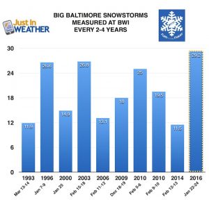
Today marks 10 years since the epic two snowstorms Baltimore received in a 5 day span. It was February 5 -10 2010 when 50 inches of snow fell in the region. This winter and our current pattern is quite a different story. It illustrate it, snow is falling in western Texas and we are getting ready for 2 to 4 inches of rain through Friday.
Bring your coat today as temps will be ‘dropping’. The 30s are already in northern Maryland and southern PA. The 50s in Central Maryland will be replaced by the 30s during the day.
Storm Ahead!
Temperatures will swing wildly, starting with a drop into the 30s today. Rain showers this morning, then a break and return of rain this evening. The cold air might lead to patchy ice between Westminster and York. But Thursday will be mostly rain. Heavy rain through Friday morning could lead to some flooding, only to be followed by some heavy snow in the mountains of Western Maryland.
Quick Cast:
- Today: Turning Colder. Rain Showers
- Tonight: Rain returns, some ice between Westminster and York
- Thursday: Heavy Rain
- Friday: Rain Ends Mid Day
- –> Sunday: Possible Snow Showers
Wednesday February 5, 2020 in Baltimore
Average High: 43ºF
Record High: 73ºF in 1991
Average Low: 25ºF
Record Low: -1ºF in 1996
*Record Snow 9.0″ in 2010
Sunrise: 7:10 AM
Sunset 5:31 PM
*Daylight = 2:10 longer than yesterday
*Bay Water Temperature = 43ºF at Thomas Pt. Light House
Get Forecasts By Email
Just in case you don’t get all posts on your social media feed, stay up to date with the latest info…
Click here to sign up for email alerts…. Be the first to hear any new weather
Morning Temperatures
Turning Colder Today
Noon: Dropping into the 30s (Southern Maryland into the 40s)
Tonight: Near Freezing across the Maryland and Pennsylvania line
‘Precipitation’ Returns This Evening
Brief icing tonight between northern Maryland and Southern Pennsylvania.
Thursday Morning
Temps will slowly warm back up in the morning.
We should be back to just a cold rain
Thursday Afternoon
Temperatures
NAM 3 KM Model keeps the colder 30 in place while the 60s reach the Lower Eastern Shore.
BUT…
GFS Model brings the warmer 50s back into metro Baltimore.
Steady rain will be heavy at times. Some local flooding possible.
Hey rain continues. Some thunderstorms possible across the lower Eastern Shore and beaches.
Friday
Heavy rain will continue in the morning. Moderate to heavy snow will return to the mountains in Western Maryland.
Snow may reach up to the mountains near I-81 into central PA. The cold front could provide a brief rain squall or rumbles of thunder early in the afternoon.
Weekend:
Snow showers still on the table early Sunday morning. This does not look to amount to much.
Temperature Outlook
Where is the cold air? It does not appear to be around next week.
Please share your thoughts, best weather pics/video, or just keep in touch via social media
-
Facebook: Justin Berk, Meteorologist
-
Twitter: @JustinWeather
-
Instagram: justinweather
WEATHER WIFE COLLECTION
- Thanks to Shannon (weather wife) for hand picking items ‘she’ wants to wear
- The Yoga Pants have side leg pocket for your phone
- The Hoodie is extra soft and has the important ‘thumb holes’
Part 1: More Snow This Winter Supported By Stats
Part 2: Solar Minimum- Low Sunspots May Mean High Snow Totals This Winter
Part 3: Tropical Systems In East Asia and Atlantic Basin Hint At Winter Storm Tracks
Snowy Winters Following A Hot and Dry September
NOAA Winter Outlook Leaves Room For More Snow With Mild ‘Seasonal Average’ Temperatures
Baltimore Weather At BWI May Not Be As Hot As Reported
Construction at the airport close to the weather station may be added artificial heat. Click here or the image for the details.
Atmospheric Memory Shaped The US East Coast
Atmospheric Memory Of Hurricanes Over Thousands Of Years Shaped The Coast
Maryland Trek Cycle Jerseys From Hill Killer
All proceeds will go to the Maryland Trek 6 total and Just In Power Kids programs
Thank you to our Title Sponsor for Maryland Trek 6
Shining on with Smyth and their contribution, our team has raised over $95,000 for Just In Power Kids to provide free programs for kids in and post cancer treatment.
Just In Power Kids:
Proceeds go to our programs Providing FREE holistic care for kids in cancer treatment and up to 5 years post treatment and caregivers.

Shine On
Proceeds from all sales go to Just In Power Kids. Click the image to shop and show your support.


