Friday January 17 2020
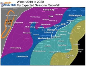
The cold air arrived yesterday evening. This came with some snow squalls that coated the ground in spots. But it’s the widespread snow and ice for Saturday that is the main focus here. This will not be a major storm, but it will impact travel in the morning for many, then the snow and ice will last the afternoon for the colder inland suburbs. I have my call for snowfall map in this post below:
Headines
- Cold air in place today (near freezing for most)
- Cold Saturday morning (20s) will chill the pavement
- Saturday Morning: Snow arrives 7 AM to 10 AM and initially will stick
- Burst of snow will drop quick coating in most areas.
- Change to icy my for many during lunchtime.
- Snow lasts longer, Ice lasts into evening in colder inland suburbs.
- Colder air returns on Sunday and will last through next week.
Morning Weather
The sloppy storm is showing up on the map this morning in the central US. That mix of snow and ice is what we expect to be here tomorrow. As I had hinted many times, computer models are suggesting the arrival time here will be earlier. I think it’s safe to say the first flakes will move in between 7 AM and 10 AM.
Temperatures and Wind Chill
We still have gusty winds. While the 20s and 30s have settled in, it does feel colder.
Friday January 17, 2020 in Baltimore
Average High: 41ºF
Record High: 69ºF in 1913
Average Low: 24ºF
Record Low: -7ºF in 1982 *Coldest on record
*Record Snow 2.5″ in 1985
Sunrise: 7:23 AM
Sunset 5:09 PM
*Daylight = 1:0 longer than yesterday
*Bay Water Temperature = 43ºF at Thomas Pt. Light House
Get Forecasts By Email
Just in case you don’t get all posts on your social media feed, stay up to date with the latest info…
Click here to sign up for email alerts…. Be the first to hear any new weather
Afternoon Temperatures
Saturday Morning
It will be down into the 20s before the snow begins. This will allow for the first flakes to stick and accumulate.
Most Likely Storm Timeline
European ECWMF Model Simulation — slider
Tracking the arrival of snow and transition to wintry mix/freezing rain, then rain.
See the temperature plots for key times below
My Call For Snowfall (and ice)
Notes:
- The timing is critical! Earlier arrival means more impact for all.
- Snow Burst or ‘Thumping’: Arrival of snow can come with a push of moderate intensity.
- The warmer Chesapeake Bay will play a role in stickage, but the initial push should coat the roads and impact travel during the morning.
- The transition from snow to sleet and freezing rain in metro areas will be between 11 AM and 2 PM. Then rain to follow before evening.
- More Snow North! The colder air will last longer (blue shading). This region will also stay frozen with ice into Saturday evening.
- Western Maryland/Wisp: They will get ice Saturday afternoon, then more snow returns Sunday.
Temperature Timing
—> slider
Please share your thoughts, best weather pics/video, or just keep in touch via social media
-
Facebook: Justin Berk, Meteorologist
-
Twitter: @JustinWeather
-
Instagram: justinweather
WEATHER WIFE COLLECTION
- Thanks to Shannon (weather wife) for hand picking items ‘she’ wants to wear
- The Yoga Pants have side leg pocket for your phone
- The Hoodie is extra soft and has the important ‘thumb holes’
Part 1: More Snow This Winter Supported By Stats
Part 2: Solar Minimum- Low Sunspots May Mean High Snow Totals This Winter
Part 3: Tropical Systems In East Asia and Atlantic Basin Hint At Winter Storm Tracks
Snowy Winters Following A Hot and Dry September
NOAA Winter Outlook Leaves Room For More Snow With Mild ‘Seasonal Average’ Temperatures
Baltimore Weather At BWI May Not Be As Hot As Reported
Construction at the airport close to the weather station may be added artificial heat. Click here or the image for the details.
Atmospheric Memory Shaped The US East Coast
Atmospheric Memory Of Hurricanes Over Thousands Of Years Shaped The Coast
Maryland Trek Cycle Jerseys From Hill Killer
All proceeds will go to the Maryland Trek 6 total and Just In Power Kids programs
Thank you to our Title Sponsor for Maryland Trek 6
Shining on with Smyth and their contribution, our team has raised over $95,000 for Just In Power Kids to provide free programs for kids in and post cancer treatment.
Just In Power Kids:
Proceeds go to our programs Providing FREE holistic care for kids in cancer treatment and up to 5 years post treatment and caregivers.

Shine On
Proceeds from all sales go to Just In Power Kids. Click the image to shop and show your support.


