Tuesday December 17 2019
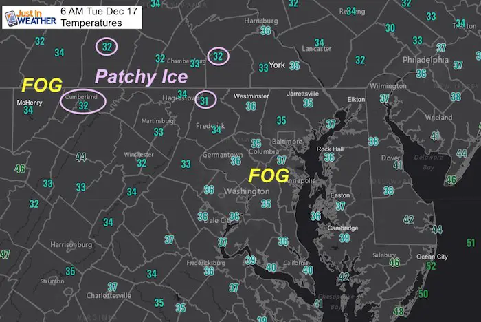
Fog is developing this morning and could become pretty thick over the next few hours. This is thanks to warmer moist air is ‘trying’ to move in over the cold and wet ground. That supersaturates the air at the surface and ‘poof’ we get a ground cloud we call fog. Some spots may hav ice in pockets in the mountains and southern PA, mainly on trees and colder surfaces. Roads are being reported as wet. Most of our region is above freezing.
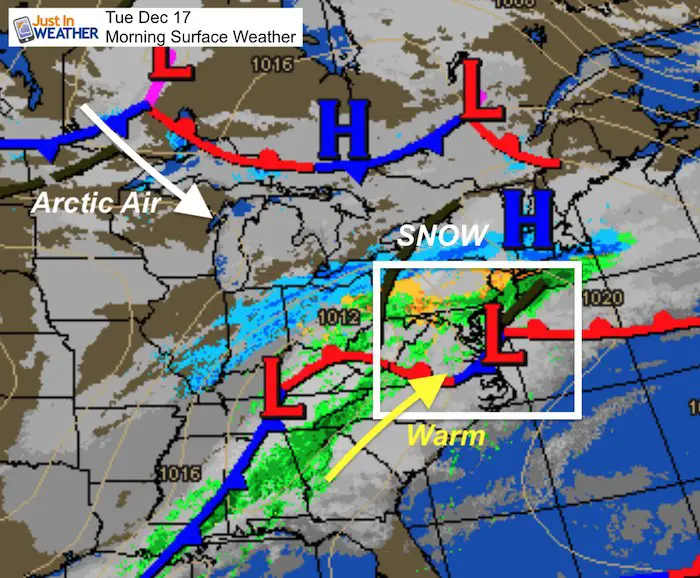
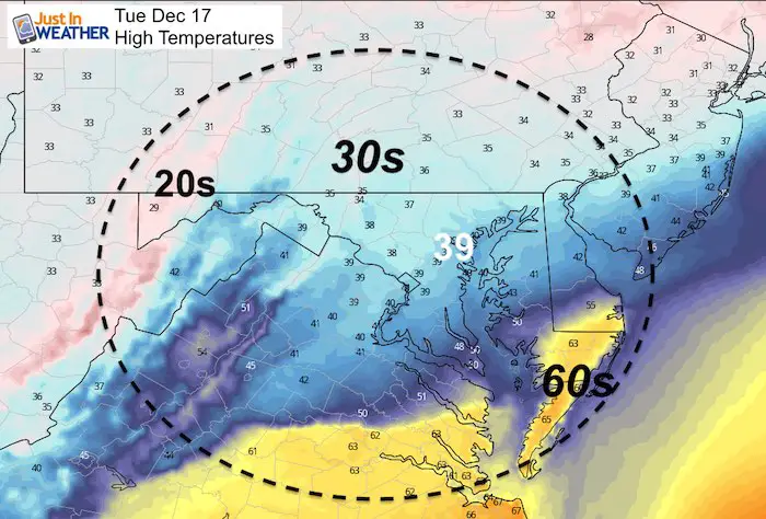
This afternoon a car ride will operated who stays in the 30s and who reaches the 60s. Farther north, an ice and snow storm will continue to rage in northern PA, New York, and New England. Following that storm a true load of arctic air spill our way for Wednesday.
Tuesday December 17, 2019 in Baltimore
Average High: 45ºF
Record High: 68ºF in 1984
Average Low: 28ºF
Record Low: 5ºF in 1951
*Record Snow 11.5″ in 1932
Sunrise: 7:19 AM
Sunset 4:44 PM
*Daylight = 0:23 shorter than yesterday
*Bay Water Temperature = 43ºF at Thomas Pt. Light House (last year was 42ºF)
*We have almost caught back to balance out the excessive warmth*
Get Forecasts By Email
Just in case you don’t get all posts on your social media feed, stay up to date with the latest info…
Click here to sign up for email alerts…. Be the first to hear any new weather

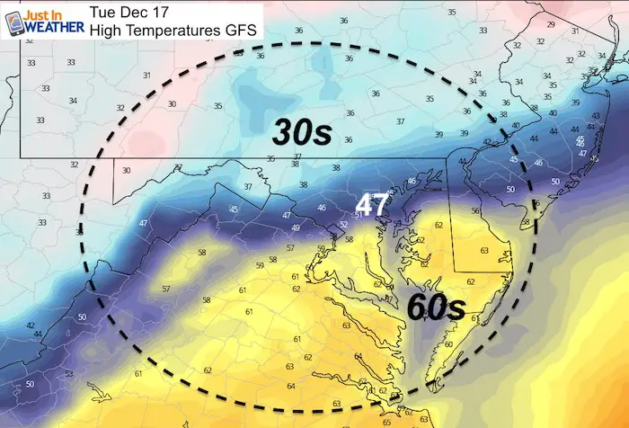
High Temperatures Today
There will be less than 100 miles separating the 30s from the 60s on Maryland’s Lower Eastern Shore.
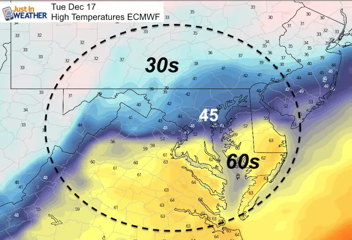
The NAM 3 Km Model is coldest keeping Baltimore in the 30s. The European ECWMF and GFS Models bring the 40s to Baltimore, but 50s close to Annapolis.
NAM 3KM Forecast
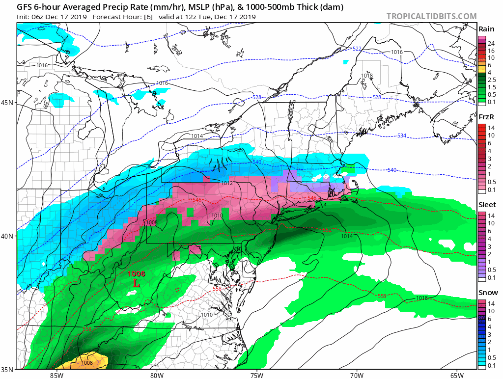
Storm Animation
Track the winter storm to our north, then dry into the weekend. What is not shown here is the cold air that fills in our way. See the temperatures below.
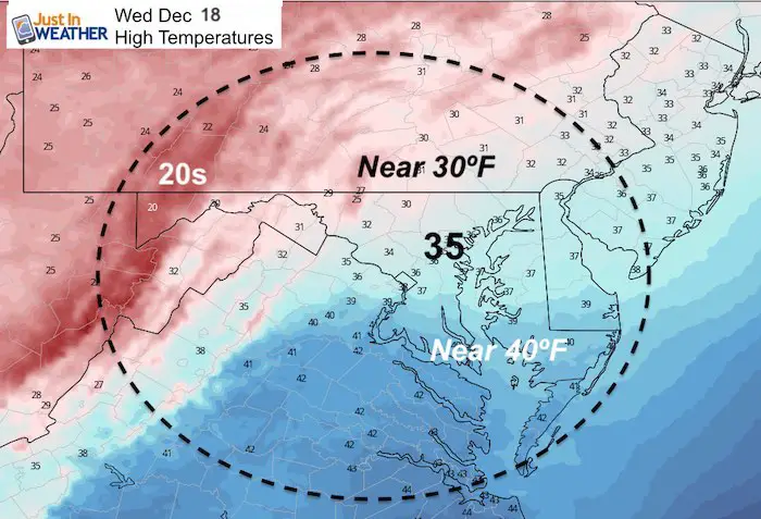
Wednesday Winter Air Returns
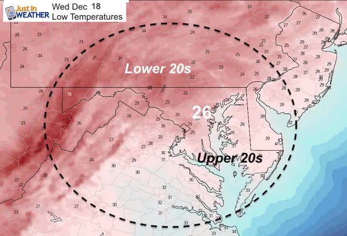
Wednesday Evening: Snow Showers
This is most likely across Pennsylvania and northern Maryland. But some flakes could get close to Metro Baltimore

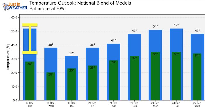
Temperature Outlook
I’ve highlighted the model spread of temps in Baltimore today. Check out the drop over the next two days! Nearly freezing in Baltimore on Thursday means 20s inland. A gradual moderation to the 50s is possible before Christmas. Note that the model accuracy one week away is not the best. There will be some adjustments to the holiday forecast.
Please share your thoughts, best weather pics/video, or just keep in touch via social media
-
Facebook: Justin Berk, Meteorologist
-
Twitter: @JustinWeather
-
Instagram: justinweather
WEATHER WIFE COLLECTION
- Thanks to Shannon (weather wife) for hand picking items ‘she’ wants to wear
- The Yoga Pants have side leg pocket for your phone
- The Hoodie is extra soft and has the important ‘thumb holes’


Part 1: More Snow This Winter Supported By Stats

Part 2: Solar Minimum- Low Sunspots May Mean High Snow Totals This Winter

Part 3: Tropical Systems In East Asia and Atlantic Basin Hint At Winter Storm Tracks


Snowy Winters Following A Hot and Dry September

NOAA Winter Outlook Leaves Room For More Snow With Mild ‘Seasonal Average’ Temperatures


Baltimore Weather At BWI May Not Be As Hot As Reported
Construction at the airport close to the weather station may be added artificial heat. Click here or the image for the details.

Atmospheric Memory Shaped The US East Coast
Atmospheric Memory Of Hurricanes Over Thousands Of Years Shaped The Coast

Was Your County Not Included?
Click this map for more on the regional forecast zones

Maryland Trek Cycle Jerseys From Hill Killer
All proceeds will go to the Maryland Trek 6 total and Just In Power Kids programs

Thank you to our Title Sponsor for Maryland Trek 6
Shining on with Smyth and their contribution, our team has raised over $95,000 for Just In Power Kids to provide free programs for kids in and post cancer treatment.

Just In Power Kids:
Proceeds go to our programs Providing FREE holistic care for kids in cancer treatment and up to 5 years post treatment and caregivers.
![]()
Shine On
Proceeds from all sales go to Just In Power Kids. Click the image to shop and show your support.
