Saturday Evening Dec 14 2019
If you are going to a holiday party this evening like me, the next weather event is likely to be a topic of conversation. So, I wanted to share my thoughts with you because there is a lot of support for first flakes arrive before sunrise, and a wintry mix that could impact some (not all) area schools. Also, it’s always safe to talk about the weather if politics come up, or someone for some unknown reason does not like the Ravens.
Headline Notes
- This earlier arrival time is what I’ve been saying for months and with this event. When it first showed up, it looked like an afternoon or evening event, but I was cautious of it doing this. The models are proving their slow error, and playing catching up. By tomorrow we should have a good handle on when this will begin across the region.
- The Chesapeake Bay water temp is still in the mid 40s. This is warmer than this time last year and will play a role in limiting impact along and east of I-95 and I-97.
- Schools could be impacted due to timing and colder air farther west and north. In Maryland some counties might make a decision based on weather that could be slick while it is wet where you are.
- How much snow? At this point it looks like a coating to 2 inches, but the icing could be a lingering issue.
- If there is icing during the morning, this often holds longer than model show.
In this post I will show the onset from three models and the simulation timeline from the European ECWMF Model. But first, how cold will we get after a dry Sunday?
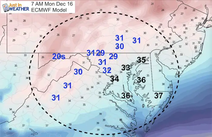
Monday Morning Sunrise Temperature Forecast
The freezing line will be just west of Washington and Baltimore.
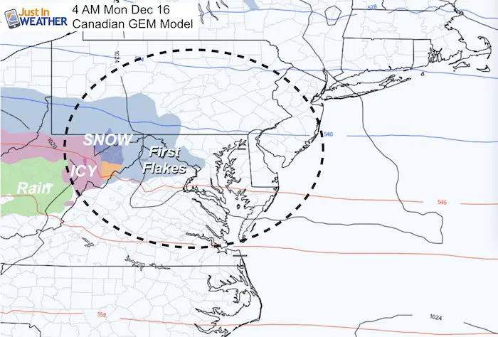
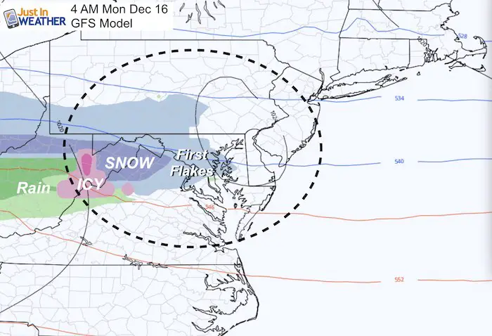
First Flakes Before Sunrise?
The Canadian and GFS Models both show the leading edge of snow entering our region at 4 AM. The Canadian is the slowest of the package suite.
We often get virga on the leading edge. This means snow on radar but it dries up (sublimates) before reaction the ground. So we can still add a buffer and get snow falling in these areas by sunrise.
European ECMWF Model
Simulation —> slider


Please share your thoughts, best weather pics/video, or just keep in touch via social media
-
Facebook: Justin Berk, Meteorologist
-
Twitter: @JustinWeather
-
Instagram: justinweather

WEATHER WIFE COLLECTION
- Thanks to Shannon (weather wife) for hand picking items ‘she’ wants to wear
- The Yoga Pants have side leg pocket for your phone
- The Hoodie is extra soft and has the important ‘thumb holes’


Part 1: More Snow This Winter Supported By Stats

Part 2: Solar Minimum- Low Sunspots May Mean High Snow Totals This Winter

Part 3: Tropical Systems In East Asia and Atlantic Basin Hint At Winter Storm Tracks


Snowy Winters Following A Hot and Dry September

NOAA Winter Outlook Leaves Room For More Snow With Mild ‘Seasonal Average’ Temperatures


Baltimore Weather At BWI May Not Be As Hot As Reported
Construction at the airport close to the weather station may be added artificial heat. Click here or the image for the details.

Atmospheric Memory Shaped The US East Coast
Atmospheric Memory Of Hurricanes Over Thousands Of Years Shaped The Coast

Was Your County Not Included?
Click this map for more on the regional forecast zones

Maryland Trek Cycle Jerseys From Hill Killer
All proceeds will go to the Maryland Trek 6 total and Just In Power Kids programs

Thank you to our Title Sponsor for Maryland Trek 6
Shining on with Smyth and their contribution, our team has raised over $95,000 for Just In Power Kids to provide free programs for kids in and post cancer treatment.

Just In Power Kids:
Proceeds go to our programs Providing FREE holistic care for kids in cancer treatment and up to 5 years post treatment and caregivers.
![]()
Shine On
Proceeds from all sales go to Just In Power Kids. Click the image to shop and show your support.
