November 19, 2019
This is the third part of my Winter Storm Outlook Series for the 2019-2020 winter season. The is my last installment before my complete outlook and formal projection for seasonal snow totals. The focus here is on teleconnections around the globe including the prior tropical season in Eastern Asia and the Atlantic Basins. We should have a busy season with plenty of storms, but where they track will make the difference of snow, ice, or rain makers. Looking at the prior tropical season could give us a hint for what to expect.
Teleconnections
One of the pioneers in long range forecasting was Dr. William Gray. In the 1970s he noticed the connection of low hurricane activity in the Atlantic when there was an El Nino event in the Pacific. He went on to find more connections around the globe, including rainfall in eastern Africa and the hurricane activity across the Atlantic a year later.
Atmospheric science treats weather patterns like a fluid, with jet streams as rivers air. If you were to drop a large rock into a pond, you can watch the ripples move across the water, and sometimes how they bounce back. If you drop a few rocks in the water, you can see how the ripples interact with each other. So, it is with that notion that meteorologists look for other connections around the globe in various seasons.
East Asia and US Connection
A strong storm in east Asia often is followed by a strong storm off the US coast (in the Gulf of Mexico or Atlantic) around 10 days later. Meteorologist Joe Bastardi was the first person I heard this from. It has proven itself many times over across many years and many seasons. I have seen this during tropical season as well as during the winter.
I been researching and tracking tropical cyclones over the past few years to see how they could hint at our winter storm tracks. My Atmospheric Memory Theory does suggest weather patterns can show up in short and long term storm tracks.
I have taken that a step farther to see if the plot of Typhoons off of east Asia in the summer and autumn can indicate how storms may track in our region, especially in the winter to follow. This is not to show exact future storm tracks, but rather the trend of the type of storms we could get.
Pacific Tropical Cyclone and Typhoons
Here is the plot of storms this past year in east Asia. In the past I have noticed that if the bulk of storms dominate along the southern path, this translates to global patterns getting locked up north and we end up warmer during the winter.
When the bulk of typhoons curve their tracks north, that results in an active jet stream around the globe. This can propagate for months. The tropical push north is eventually balanced by high amplitude waves and dominate cold surges south in the following winter. We have already seen some of this with record snow in the central US in October and on pace for a record cold November.
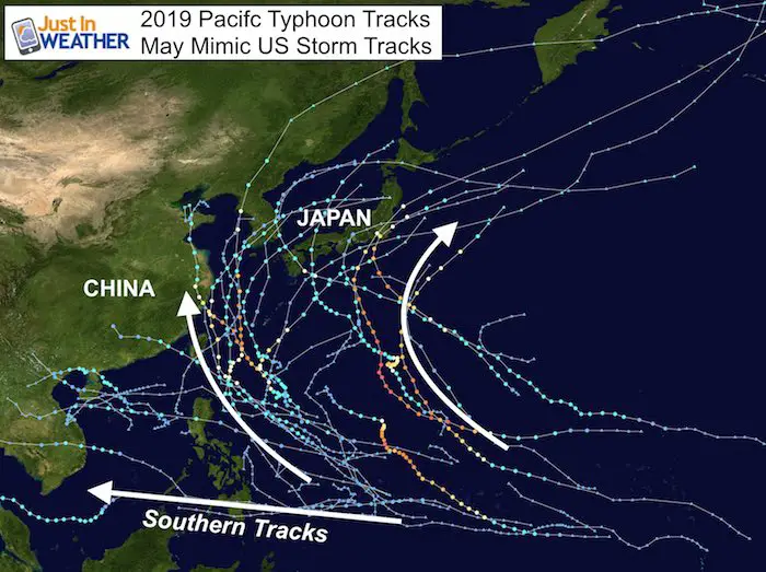
Japan Tracks and US East Coast Storms
When quite a few storms track through or east of Japan, the resulting pattern in our Hemisphere often translates to more coastal storms along the US…
—> slider


West Of Japan And China Storm Tracks
There were plenty of those as well this year. These still influence the long wave global jet stream, but correspond to US storms that tend to track inland, up the Mississippi and Ohio Valleys.
—> slider
Atlantic Basin Storms
My intent now is not correlate the time connection of the Pacific and Atlantic storms I mentioned above. The purpose here is just for the pattern of storm tracks. The tropical cyclone tracks seen here in the Atlanic (and Gulf) reflect a lot more systems curving north than the southern paths. The is just like the Eastern Asia season. North tracks influence the northern jet stream and those that track really far north, three systems that reaches far north into the United Kingdom that has left ripples in the northern jet stream that will continue to propagate out.
This is one of the reasons we have already seen very deep troughs that brought us record snow in the Mid west and record cold to the eastern half of the US over between October and the first half of November.
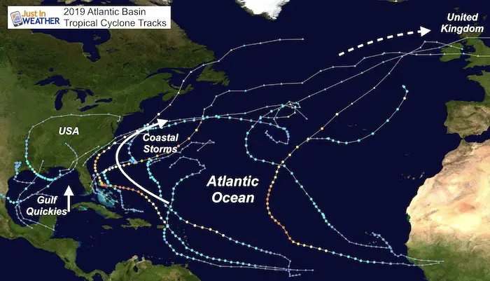
In relation to the US, and more specifically us in the Eastern US, this can be further identified as Gulf of Mexico storms tracking inland up the Mississippi and Ohio Valley, or to the East Coast. We can also look at coast systems that curved out into the Atlantic.
Gulf Quickies
There were four storms of note that spent a brief time in the Gulf of Mexico and tracked into the US.
There were a wide variety of tracks starting with Barry. This was a unique Upper Low that starting inland and dropped south to the Gulf to turn tropical, then loop north. Imelda and Olga also were close to Louisiana, which leads me to see this area as a hot bed for development of storms this winter.
—> slider
Nestor is the one I see as most important as it was this that gave us a soaking rain event and overachiever in October. It was that Sunday Oct 20 that followed a week after the ‘bomb storm’ in the Northeast.

Bomb Storm A Week Earlier

*If the global pattern operates on a 45 to 60 day cycle, then we could see repeating storms like these in the first half of December.
East Coast Storms
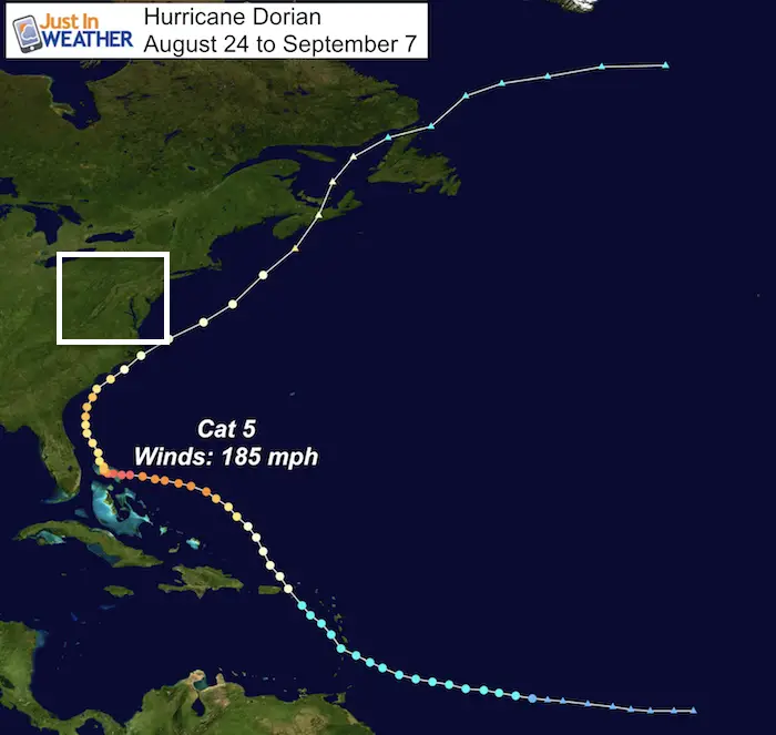
Hurricane Dorian
This record Category 5 Hurricane is the one that stalled over the Bahamas with 185 mph winds. This impacted the southeast US, but curved away form the Mid Atlantic. Many storms do that and a few are likely to follow suit this winter.
Tropical Storm Melissa
This was a Tropical Storm in October that you might not be familiar with, because it never hit land. It formed off of the North Carolina coast and moved essay. But it stalled and looped for a few days. I am highlighting this storm because it did have an impact on us.

October 12 Costal Fooding
The stalling of Melissa along wth strong High Pressure in eastern Canada resulted in a persistent onshore flow. This piled water along the coast and up the Chesapeake Bay. This was the storm that led to beach flooding and flooding in Annapolis during the boat show. Even when we don’t get the direct impact of a coastal storm, sometimes it can lead to flooding on our shorelines.
I do expect this winter will have a few repeats of flooding at the beach and on the ‘Bay

Likely Common Winter 2019-2020 Tracks
A high amplitude jet stream will make for powerful winter storms, but the likely tracks seen here will determine what type of weather we will get:
I expect and active winter translating into a lot of storms to count. Plenty of these will originate in the Gulf of Mexico and coastal Louisiana is a spot to watch. A few will team up again with moisture from the Pacific Ocean with plenty of moisture. I have good reason to believe that we will have at least one BIG winter storm for us (see the chart below). But not all will be the same, which usually is the case.
The storm tracks and weather for us are explained below.
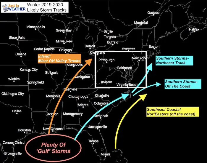
Inland (Mississippi/Ohio Valley Tracks):
These are storms that will track up the Mississippi or Ohio River Valleys. These are snowmakers for the MidWest, but pump in warmer air for us in the Mid Atlantic. The Ohio Valley tracks are storms that can bring us some ice storms, or the snow/ice mix that turns to rain.
Southern Storms:
These also originate from the Gulf of Mexico, but will do one of two things when they reach North Carolina:
- Northeast Storms: These storms turn or redevelop off of the coast and will be the big snow makers for us. This is similar to the track Nestor by us on October 20th. The statistical pattern does support that we are due for at least one big storm (10”+ in the city) this winter, and it is likely to come from a storm along this path.
- Southern Storms Off The Coast: These are the storms that can bring southern Maryland and the beaches snow, while missing the cities and normally colder inland spots. I expect we should see 2 or 3 of these during the winter.
Southeast Coastal Storms
These may be the big teases of the season. I see this similar to the track of Hurricane Dorian and Melissa. Some storms that develop off the Florida to North Carolina coast and impact the southeast US. But as has been the trend, the forcing will shove them east of North Carolina and just out of our reach, but the high water will still lead to coastal and ‘Bay flooding.
We Are Due For At Least One Big Storm This Winter

When I look at the statistics of snowfall in our area, there are patterns that pop up. One of those patterns has been a large storms with over 11 inches of snow in Baltimore as see here. Many of these produced a lot more than shown in the colder inland suburbs.
While I started this chart in 1993, the pattern of one large snowstorm every three to four years dates back to the 1970s. There were three in the winer of 2009 to 2010. The one storm that messed up the pattern was January 2016 with our record 29.2″. That was our largest snow event on record and was only two years after the previous storm, shortening the time span in between (2014).
This coming January (2020) will be 4 years that have spanned since our last ‘big’ winter storm. If you believe in the pattern, along with the discussion above, then at least one of those should bring metro areas a double digit snowfall.
Computer Model Error With Storm Tracks
I will caution you that storms projected by computer model guidance have flaws! Often they are likely to verify faster and farther east. Western or warmer storms shown on a computer model, may end up east, colder, and with more snow for our region. But some prospects for big snow a few days away verity farther east, and up missing or given us less.
FITF
Faith in the Flakes! Keep checking back as I will have my full and formal winter outlook shortly. The next winter outlook I post will have my call for snow totals for the next season. Hopefully by early December we will get an early start, and my new website will be ready with a lot more data, and easier navigation for you.
NEW FITF GEAR THIS YEAR
- Thanks to Shannon (weather wife) who wanted to bring these hats to life. *Mustard is her favorite color
- The Maryland Hoodie is high quality and a new way to show off our love of Snow and State.
- The T-shirt… Something you may find familiar. Why just a T? Because many schools I visit have the heat on high for faculty and staff. But you can put a long sleeve underneath for cool look. I will have wifey model these soon 🙂

Please share your thoughts, best weather pics/video, or just keep in touch via social media
-
Facebook: Justin Berk, Meteorologist
-
Twitter: @JustinWeather
-
Instagram: justinweather
Winter Outlook Posts
Part 1: More Snow This Winter Supported By Stats

Part 2: Solar Minimum- Low Sunspots May Mean High Snow Totals This Winter

Snowy Winters Following A Hot and Dry September

NOAA Winter Outlook Leaves Room For More Snow With Mild ‘Seasonal Average’ Temperatures


Baltimore Weather At BWI May Not Be As Hot As Reported
Construction at the airport close to the weather station may be added artificial heat. Click here or the image for the details.

Atmospheric Memory Shaped The US East Coast
Atmospheric Memory Of Hurricanes Over Thousands Of Years Shaped The Coast

Was Your County Not Included?
Click this map for more on the regional forecast zones

Maryland Trek Cycle Jerseys From Hill Killer
All proceeds will go to the Maryland Trek 6 total and Just In Power Kids programs

Just In Power Kids:
Proceeds go to our programs Providing FREE holistic care for kids in cancer treatment and up to 5 years post treatment and caregivers.
![]()
Shine On
Proceeds from all sales go to Just In Power Kids. Click the image to shop and show your support.
