Tuesday November 12 2019
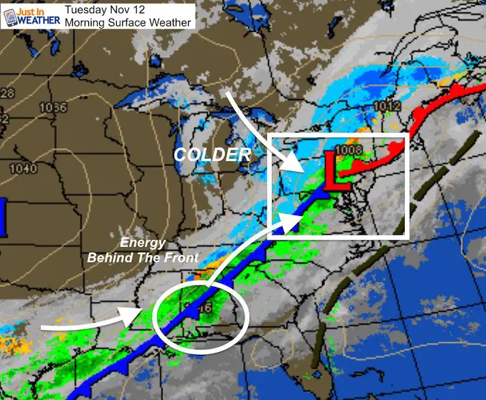
We have already hit the high temperature for the day. A strong cold front will arrive this morning, and it begins with rain. Temps will fall quickly for most areas reaching the 20s or colder across the state tonight. Snow will develop behind the front then spread our way. The excitement of watching snow falling should be contained by lack of stickage. FITF- Most of us should see snow falling later this morning into the afternoon starting from the northern suburbs of Baltimore and then reaching lower Delmarva.
Wet Roads For Most
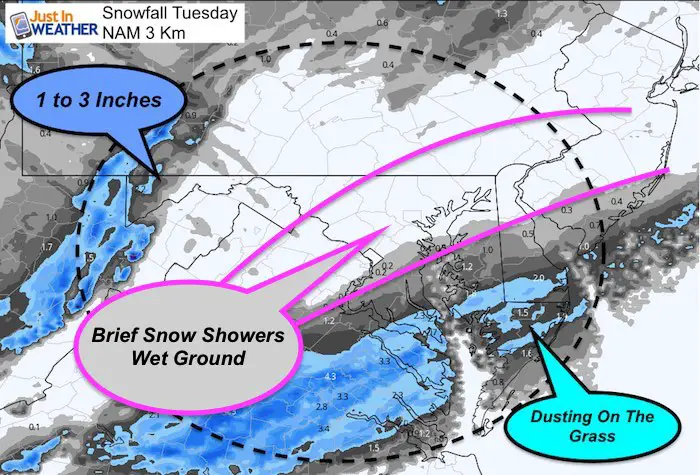
The ground is warm and temps should stay above freezing during the day! So, the roads will remain wet. Western Maryland could see 1 to 3 inches in Garrett County. The burst of snow may be stronger on Delmarva this afternoon. This could coat the grass there. The once concern will be wet roads as temps crash after sunset that could get a little icy tonight on The Lower Eastern Shore. See the simulation sliders below
Headlines
- Morning Rain: Falling Temps Quickly!
- Snow Showers Develop In Metro Areas 9 AM to Noon.
- Metro Snow Likely On Wet Roads
- Snow Burst Develops In Southern MD and Delmarva Noon to 4 PM.
- Delmarva Snow May Coat Grass. Wet Roads After Sunset Could Get Icy
- Winter Weather Advisory in Garrett County (1-3 inches)
Local Weather Stats:
Tuesday November 12, 2019 in Baltimore
Average High: 58ºF
Record High: 78ºF in 1879
Average Low: 38ºF
Record Low: 18ºF in 1957
Sunrise: 6:46 AM
Sunset 4:54 PM
*Daylight = 2:00 shorter than yesterday
*Bay Water Temperature = 56ºF at Thomas Pt. Light House
Get Forecasts By Email
Just in case you don’t get all posts on your social media feed, stay up to date with the latest info…
Click here to sign up for email alerts…. Be the first to hear any new weather
Thank you to our Title Sponsor for Maryland Trek 6
Shining on with Smyth and their contribution, our team has raised over $95,000 for Just In Power Kids to provide free programs for kids in and post cancer treatment.
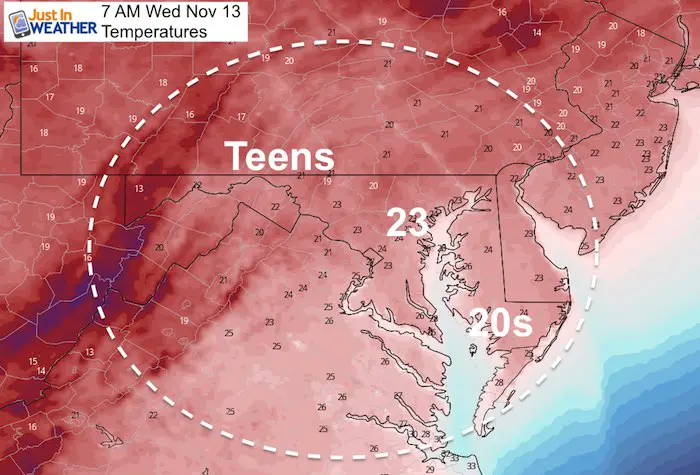
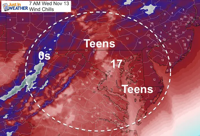
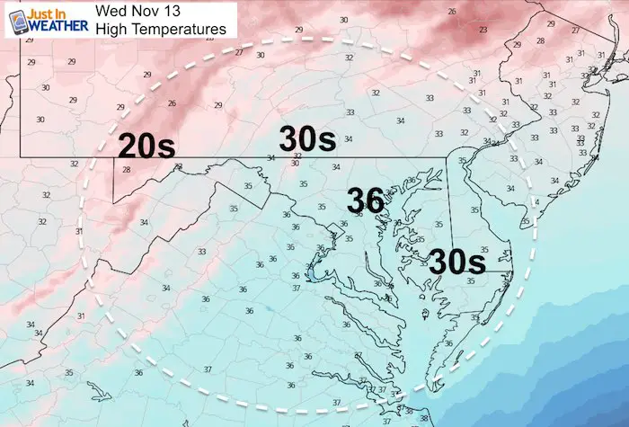
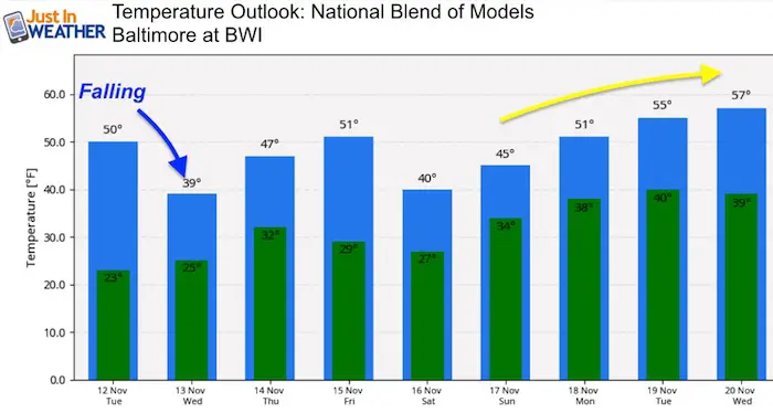
Morning Temperatures
Radar Simulations (Compare HRRR to NAM 3 Km)
- A lull after the rain and snow developing in metro areas between 9 AM and noon
- Burst of moderate to heavy snow on Delmarva AFTER 12 PM Noon
HRRR Rain/Snow Timeline —> slider
NAM 3 Km Rain/Snow Timeline —> slider
NEW FITF GEAR THIS YEAR
- Thanks to Shannon (weather wife) who wanted to bring these hats to life. *Mustard is her favorite color
- The Maryland Hoodie is high quality and a new way to show off our love of Snow and State.
- The T-shirt… Something you may find familiar. Why just a T? Because many schools I visit have the heat on high for faculty and staff. But you can put a long sleeve underneath for cool look. I will have wifey model these soon 🙂
Please share your thoughts, best weather pics/video, or just keep in touch via social media
-
Facebook: Justin Berk, Meteorologist
-
Twitter: @JustinWeather
-
Instagram: justinweather
Winter Outlook Posts
Part 1: More Snow This Winter Supported By Stats
Part 2: Solar Minimum- Low Sunspots May Mean High Snow Totals This Winter
Snowy Winters Following A Hot and Dry September
NOAA Winter Outlook Leaves Room For More Snow With Mild ‘Seasonal Average’ Temperatures
Baltimore Weather At BWI May Not Be As Hot As Reported
Construction at the airport close to the weather station may be added artificial heat. Click here or the image for the details.
Atmospheric Memory Shaped The US East Coast
Atmospheric Memory Of Hurricanes Over Thousands Of Years Shaped The Coast
Maryland Trek Cycle Jerseys From Hill Killer
All proceeds will go to the Maryland Trek 6 total and Just In Power Kids programs
Just In Power Kids:
Proceeds go to our programs Providing FREE holistic care for kids in cancer treatment and up to 5 years post treatment and caregivers.

Shine On
Proceeds from all sales go to Just In Power Kids. Click the image to shop and show your support.


