Thursday September 5 2019
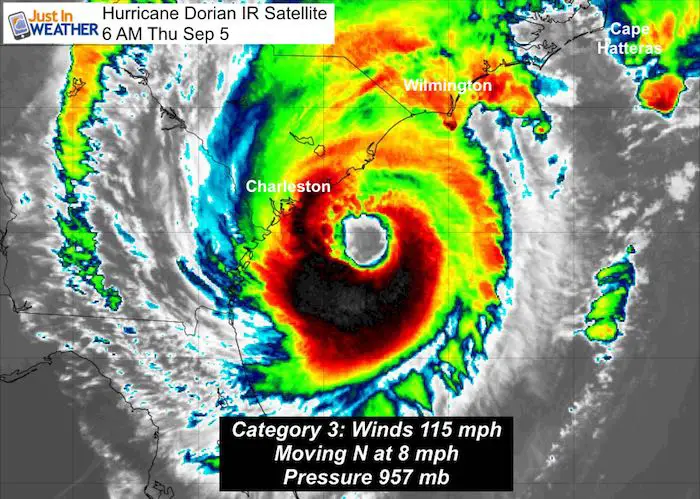
Hurricane Dorian looked like it was getting stronger yesterday over the Gulf Stream water and now we have confirmation. The winds are up to 115 mph, making this a Category 3 storm once again. This is as it makes a closer approach to South Carolina this morning and the winds extend farther from the center. Top hazards include wind damage, storm surge, flooding rain, and tornadoes within rain bands.
Landfall is expected in eastern North Carolina, but the impacts of Tropical Storm Conditions (winds over 39 mph and 4 to 7 Ft Storm Surge) extend to Virginia and Southern Maryland. Gusty winds and lighter rain will reach metro Baltimore and possibly up to York PA Friday. Forecast maps below:
Hurricane Dorian IR Satellite
Hurricane Dorian Headlines:
- Tropical Storm Watch includes southern Maryland for: Heavy Rain, Strong Winds, Coastal Flooding, and Isolated Tornadoes
- Tropical Storm Warning On Chesapeake Bay From Smith Point southward
- Hurricane Dorian is a Cat 3 with 115 mph winds
- Hurricane force winds reach 60 miles from the center
- Tropical Storm force winds reach 195 miles from the center
- Center is 80 miles SSE of Charleston, SC, likely to make landfall in NC
- Navy ships left Norfolk, VA to ride out the storm in the ocean
- Impact for Ocean City highest on Friday: Winds 40 to 60 mph
- Watches also posted for Nantucket and Martha’s Vineyard in New England
Also see: Atmospheric Memory Of Hurricanes Over Thousands Of Years Shaped The Coast
Tropical Storm Watches And Warnings
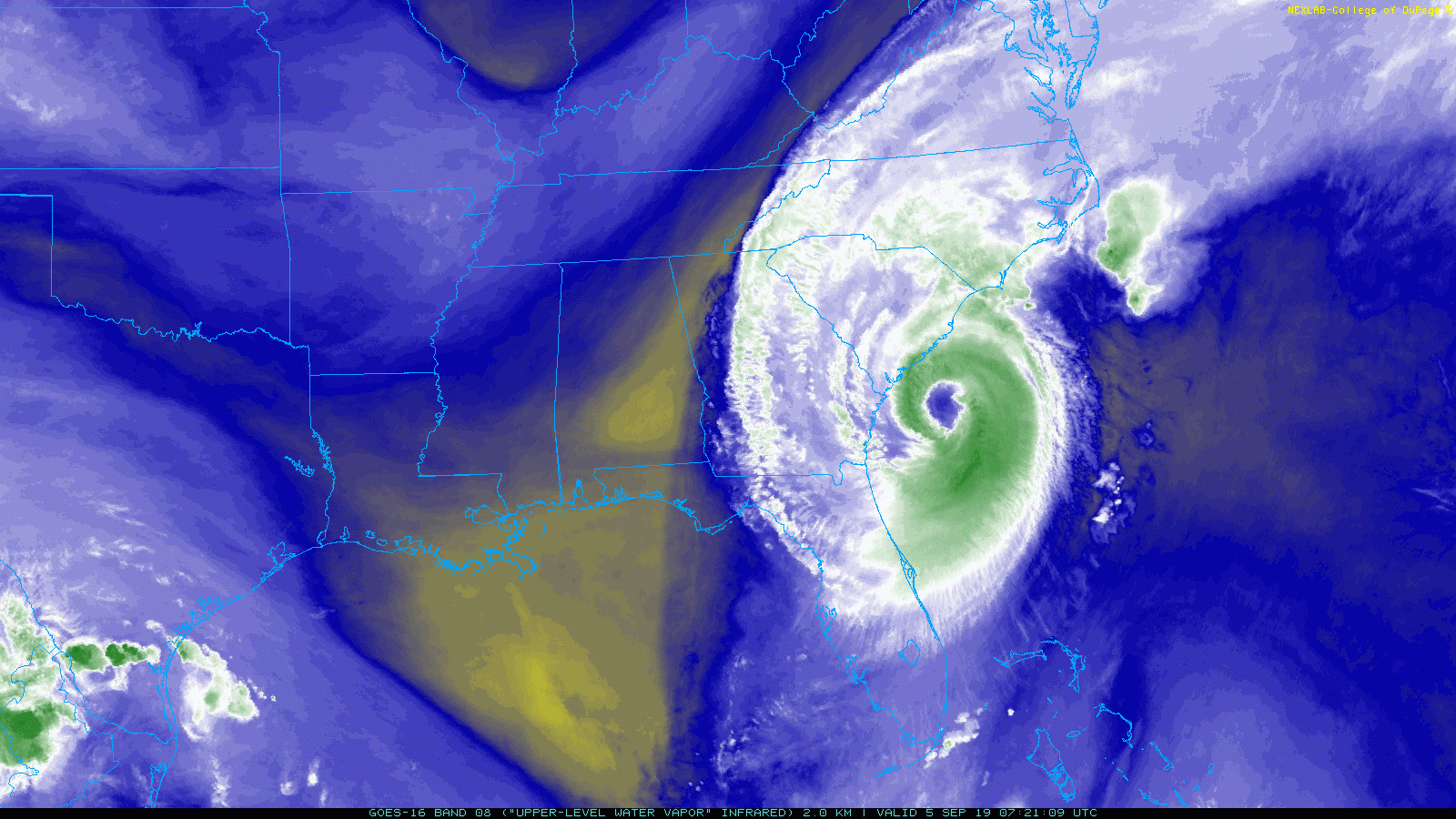
Hurricane Dorian Water Vapor Loop
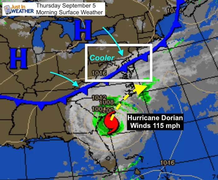
Morning Surface Map
The clouds from Dorian have reached Maryland and Southern PA. The cold front that will keep us in the 70s today, will help steer the storm out to the Atlantic. However, rain will form as it interacts with the front and push back into central Maryland and perhaps southern PA Friday.
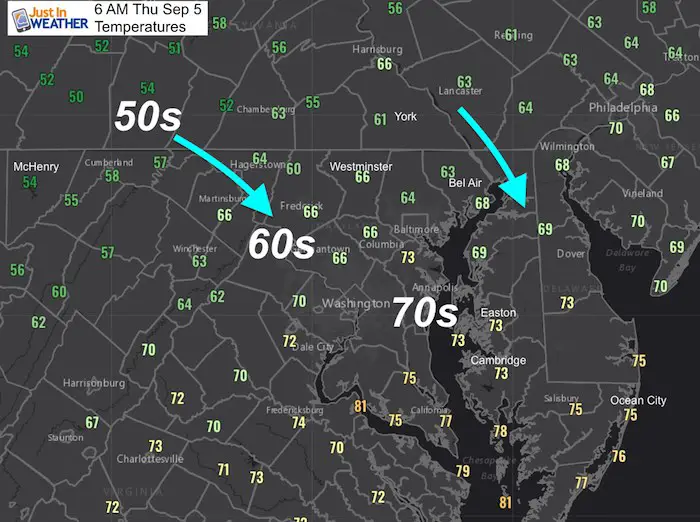
Morning Temperatures
Cooler air is filtering in from the Northwest. If you wake up in the 70s in Maryland , your area should stay there this afternoon.
Forecast Maps
European ECMWF Model —> slider
- The closest pass will be Friday afternoon and evening.
- Rain on the northern fringe will reach into central Maryland, perhaps southern PA. There it will be lighter and chilly, but gusty.
[metaslider id=79691]
NAM Model —> slider
Local reach of rain
[metaslider id=79684]
Hurricane Dorian Winds —> slider
[metaslider id=79702]
I will have an update on the local wind forecast in my next post
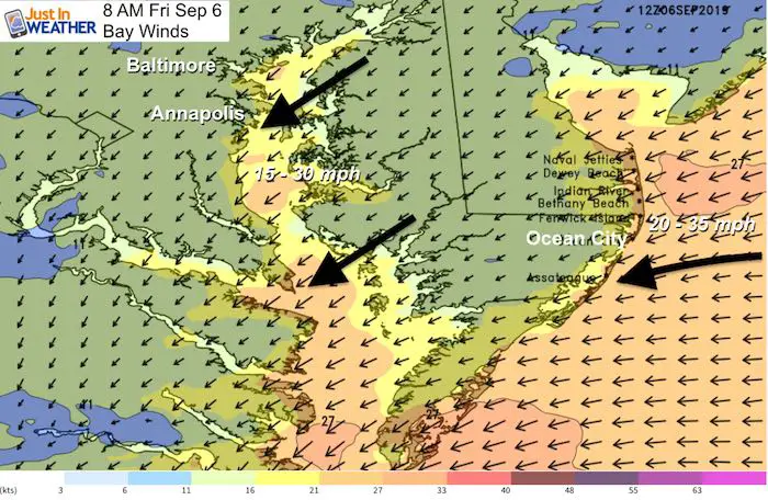
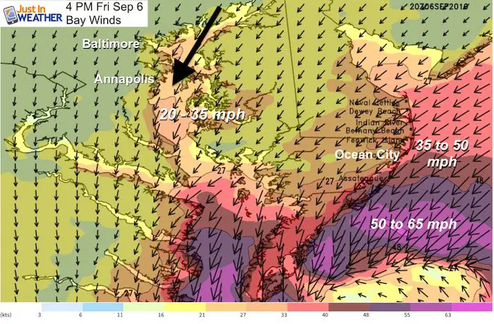
Closer Look At The Chesapeake Bay Winds
Sloshing Flooding: Winds from Northeast will impact western shore of the Bay later today and tonight.
Winds will shift from the Northeast to the North during Friday.
Winds increase and likely lead to restrictions on the area bridges. It will seem like a strong Nor’easter.
Friday Afternoon: Strongest Winds swing to from the north. Best chance for the beaches to get into Tropical Storm Conditions.
SUMMARY OF WATCHES AND WARNINGS IN EFFECT:

A Storm Surge Warning is in effect for...
* Savannah River to Poquoson VA
* Pamlico and Albemarle Sounds
* Neuse and Pamlico Rivers
* Hampton Roads

A Hurricane Warning is in effect for...
* Savannah River to the North Carolina/Virginia border
* Pamlico and Albemarle Sounds

A Tropical Storm Warning is in effect for...
* North Carolina/Virginia border to Chincoteague VA
* Chesapeake Bay from Smith Point southward

A Tropical Storm Watch is in effect for...
* North of Chincoteague VA to Fenwick Island DE
* Chesapeake Bay from Smith Point to Drum Point
* Tidal Potomac south of Cobb Island
* Woods Hole to Sagamore Beach MA
* Nantucket and Martha's Vineyard MA
Keep In Touch Every Day
Just in case you don’t get all posts on your social media feed, stay up to date with the latest info…
Click here to sign up for email alerts…. Be the first to hear any new weather
Thank you to our Title Sponsor for Maryland Trek 6
Shining on with Smyth and their contribution, our team has raised over $95,000 for Just In Power Kids to provide free programs for kids in and post cancer treatment.

Please share your thoughts, best weather pics/video, or just keep in touch via social media
-
Facebook: Justin Berk, Meteorologist
-
Twitter: @JustinWeather
-
Instagram: justinweather
Maryland Trek Cycle Jerseys From Hill Killer
All proceeds will go to the Maryland Trek 6 total and Just In Power Kids programs

Just In Power Kids:
Proceeds go to our programs Providing FREE holistic care for kids in cancer treatment and up to 5 years post treatment and caregivers.
![]()
Shine On
Proceeds from all sales go to Just In Power Kids. Click the image to shop and show your support.

Love Maryland Shirts and Hoodies
This shirt was designed by my ‘bonus’ daughter Jaiden. The hoodie has been the biggest hit, so our promotion has been extended until the end of this week.
|
||
|
Show your love for Maryland and make this 14 year old artist and her mom extra proud
|


Related Links:
Was Your County Not Included?
Click this map for more on the regional forecast zones
