Saturday July 13 2019
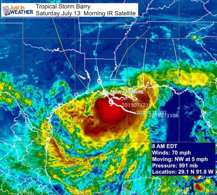
The morning update on Tropical Storm Barry has winds of 70 mph as it approaches the coast. This wind speed is not the important factor and to be a hurricane it only needs to have 74 mph winds. The slow movement and heavy flooding along an already high Mississippi River Basin is the big story. That is there, but what about here in the Mid Atlantic? Tracking that storm inland shows it will weaken, but some of the energy will feed into our region next week.
Note: Locally we will have a warm and quiet weekend. This post is a focus on TS Barry and how it could impact our weather with storms by Tuesday and Wednesday.
Tropical Storm Barry Satellite and Stats
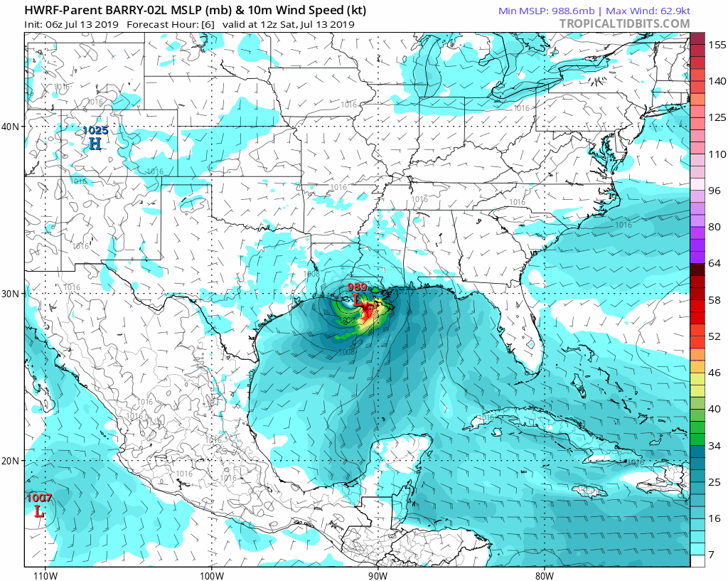
The forecast shows this moving inland today, likely remaining a tropical storm or minimal hurricane, then weakening across northern Louisiana by tonight. The slow track takes it north into Arkansas an Missouri by the end of the weekend. See the following forecast animation below.
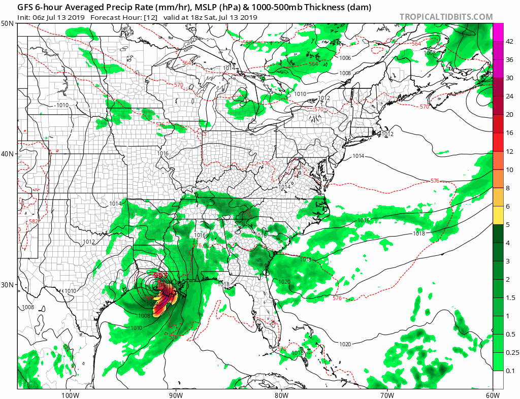
The bulk of the energy and moisture is on the south side of the storm. This is loaded on the back side of the storm with respect to its movement. So the lack of rain this morning can be deceiving.
Flooding
The bulk of the rainfall is still well offshore this morning. It is likely to build back this afternoon and continue possibly through Monday. This is loaded on the south side of the system as seen above.
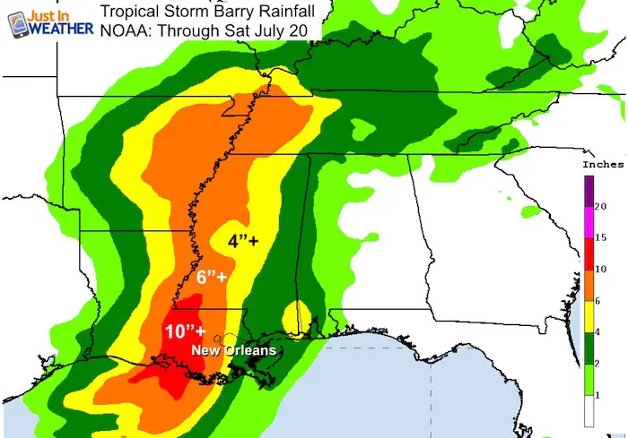
Heavy rain in a narrow band just east of the center. At this point that looks to miss New Orleans, but the rain fall will drain into the Mississippi River and still lead to flooding as it flows towards the Gulf.
Keep In Touch Every Day
Just in case you don’t get all posts on your social media feed, stay up to date with the latest info…
Click here to sign up for email alerts…. Be the first to hear any new weather.
Storm Forecast
National Hurricane Center Forecast Track
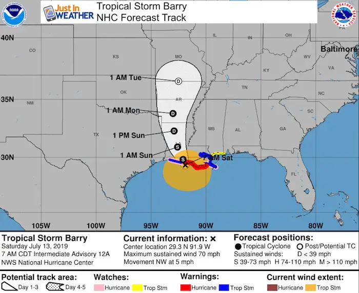
SUMMARY OF WATCHES AND WARNINGS IN EFFECT...

A HURRICANE WARNING IS IN EFFECT FOR...
* INTRACOASTAL CITY TO GRAND ISLE

A TROPICAL STORM WARNING IS IN EFFECT FOR...
* MOUTH OF THE PEARL RIVER TO GRAND ISLE
* LAKE PONTCHARTRAIN AND LAKE MAUREPAS INCLUDING METROPOLITAN NEW
ORLEANS
* INTRACOASTAL CITY TO CAMERON

A STORM SURGE WARNING IS IN EFFECT FOR...
* INTRACOASTAL CITY TO BILOXI
* LAKE PONTCHARTRAIN

A STORM SURGE WATCH IS IN EFFECT FOR...
* BILOXI TO THE MISSISSIPPI/ALABAMA BORDER

A HURRICANE WATCH IS IN EFFECT FOR...
* MOUTH OF THE MISSISSIPPI RIVER TO GRAND ISLE
* INTRACOASTAL CITY TO CAMERON

A TROPICAL STORM WATCH IS IN EFFECT FOR...
* EAST OF THE MOUTH OF THE PEARL RIVER TO THE MISSISSIPPI/ALABAMA
BORDER
Forecast Track Inland
Local Rainfall Begins Tuesday
The GFS Model shows the increase in thunderstorms Tuesday afternoon and evening, into Wednesday. This is NOT Barry but will be influenced from the rainfall feeding into the next front. After a nice and dry weekend, it will become more humid. We could have locally heavy downpours and flooding Tuesday and Wednesday. The chance of showers will continue through Friday. 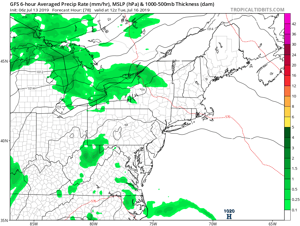
Please share your thoughts, best weather pics/video, or just keep in touch via social media
-
Facebook: Justin Berk, Meteorologist
-
Twitter: @JustinWeather
-
Instagram: justinweather
Bring Your Kids To Join My Team: Maryland Trek 6
Kids Trek Too!
Bring Your Kids To Join My Team This Summer
Click the logo for more information
![]()

Support Our Nonprofit:
Proceeds go to our programs Providing FREE holistic care for kids in cancer treatment and up to 5 years post treatment and caregivers.
![]()
Shine On
Proceeds from all sales go to Just In Power Kids. Click the image to shop and show your support.

Love Maryland Shirts and Hoodies
This shirt was designed by my ‘bonus’ daughter Jaiden. The hoodie has been the biggest hit, so our promotion has been extended until the end of this week.
|
||
|
Show your love for Maryland and make this 14 year old artist and her mom extra proud
|


Related Links:
Was Your County Not Included?
Click this map for more on the regional forecast zones
