Monday April 8 2019
There is an old saying in Maryland that we often jump right from winter to summer. It might feel like that for the next two days as temperatures will be up around 80 degrees. If BWI reaches that mark, it will be the first time this year. This morning you may wake up with damp pavement, but most of today will be dry. However showers and thunderstorms will develop this afternoon. There is a chance in metro Baltimore to get in on some action between 4 PM and 8 PM. But the main event will be reaching southern Maryland this evening.
The Severe Storm Outlook for today shows a Marginal Risk for southern Maryland. There will be strong storms, but reaching severe levels is not guaranteed. If so, then winds could gust to 60 mph with large hail.
See the timeline slider below.
The main batch of severe weather will be between Georgia, SC, NC, and Virginia.

Local Weather Stats For April 8, 2019 in Baltimore
Average High: 62ºF
Record High: 91ºF in 1929
Average Low: 41ºF
Record Low: 26ºF in 1982
*Record Snow: = 4.0″ in 1916
Sunrise: 6:40 AM
Sunset 7:36 PM
*Daylight = 2:31 longer than yesterday
*Bay Water Temperature = 50ºF at Thomas Pt. Light House
Keep In Touch Every Day
Just in case you don’t get all posts on your social media feed, stay up to date with the latest info…
Click here to sign up for email alerts…. Be the first to hear any new weather.
Maryland Trek 6
Our look got an upgrade, but we have the same purpose. Please click the logo take a look at our new page.
- Consider joining our team for the week, a single day, or even as a sponsor.


New Partner
Buchanan Kia of Westminster is a supporter of Just In Power Kids and Maryland Trek 6 in August 2019.
Morning Temperatures

Afternoon High Temperatures

Radar Simulation: Rain Timeline —> slider
[metaslider id=75447]
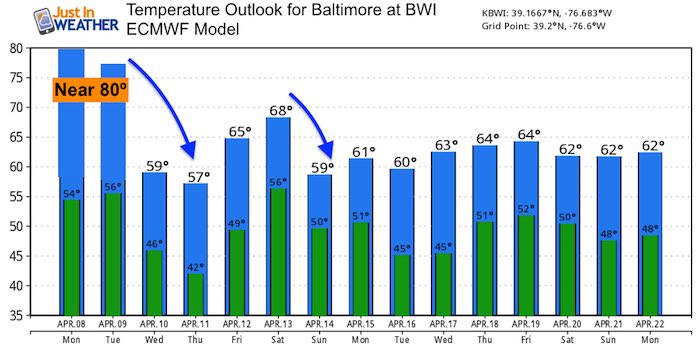
Tuesday Temperatures
We will have one more day with a very warm feel.
Morning Lows

Afternoon Highs

Looking Ahead
Temperatues will be cooler mid week, then we mark Friday for the next chance of rain. A larger storm will arrive late Sunday into Monday next week.
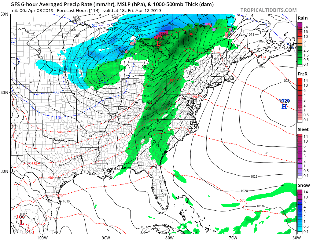
Temperature Outlook
Keep In Touch Every Day
Just in case you don’t get all posts on your social media feed, stay up to date with the latest info…
Click here to sign up for email alerts…. Be the first to hear any new weather.
Please share your thoughts, best weather pics/video, or just keep in touch via social media
-
Facebook: Justin Berk, Meteorologist
-
Twitter: @JustinWeather
-
Instagram: justinweather
Related Links:
Was Your County Not Included?
Click this map for more on the regional forecast zones
