Monday March 4 2019
The latest storm is moving out this morning, brining moderate snow to New England. This ended up shifted the snow line about 30 miles north, so parts of central Maryland feel like they missed out, but there are plenty that did get snow and ice that is still around this morning.

Northern counties in Maryland and southern PA have 2 hour school delays this morning. This includes Cecil, Harford, northern Baltimore, and Carroll Counties.
Updated Temperatures at 7 AM
Temperatures are near or below freezing here, so if there are untreated surfaces or wet pavement, there could be some icing through about 8 AM.

See the temperature timeline below. Also the big story this week which will be much colder air on the way. There is a chance for some light snow Friday with a storm that will turn to rain.
Early Snow Report
The snow bands shifted about 30 miles north of my forecast
I will have a full report later today

Temperature Timeline Through Noon
HRRR Model –> slider
[metaslider id=74431]
Turning Really Cold
Afternoon Wind Chill

Local Weather Stats For March 4, 2019 in Baltimore
Average High: 50ºF
Record High: 80ºF in 1923
Average Low: 30ºF
Record Low: 4ºF in 2014
*Record Snow: = 8.2″ in 1909
Sunrise: 6:35 AM
Sunset 6:01 PM
*Daylight = 2:32 longer than yesterday
*Bay Water Temperature = 39ºF at Thomas Pt. Light House
Keep In Touch Every Day
Just in case you don’t get all posts on your social media feed, stay up to date with the latest info…
Click here to sign up for email alerts…. Be the first to hear any new weather.

New Partner
Buchanan Kia of Westminster is a supporter of Just In Power Kids and Maryland Trek 6 in August 2019.
Wednesday Will Be The Coldest Day
Morning Lows

Afternoon Highs: Staying in the 20s

Temperature Outlook
Changes on the way next week. We have one more system to get through on Friday, then back closer to normal temperatures.
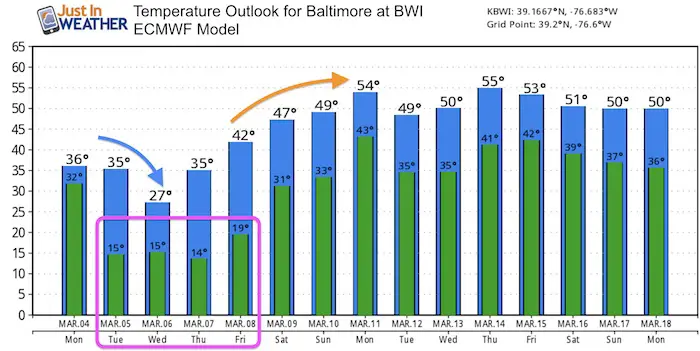
End Of Week Storm
The chance for more snow will be Friday. This system is worth watching with the morning timing. That is when we get the most impact in March. But this should turn to rain as it passes by.
ALL FITF Apparel

Please share your thoughts, best weather pics/video, or just keep in touch via social media
-
Facebook: Justin Berk, Meteorologist
-
Twitter: @JustinWeather
-
Instagram: justinweather

20% Off End Of Season Sale
Use PromoCode: lasthurrah20
New Colors
We are giving 10% of each sale to Just In Power Kids: Providing FREE holistic care for pediatric oncology patients.

Related Links:
Winter Outlook
My Winter Outlook 2018-19: Multiple Nor’Easters and more snow

Was Your County Not Included?
Click this map for more on the regional forecast zones

Interactive Snow Report
November 15 Snow Reports- Interactive Map Compared To My Forecast

Winter Snow And Top 5 Wet Years
Snowfall Seasons at Beginning and End of Top 5 Wet Years In Baltimore

Related Winter Outlooks
Solar Cycle: When Sun Spots Are Low We Get More Snow
El Nino Modoki May Enhance Snow Chances
Sweet Spot: Hitting 70ºF on Halloween is followed by more winter snow
Will A Wet Summer Bring A Snowy Winter?
NOAA Winter 2018-2019 Outlook Explained: This Actually Supports Snow
Winter Outlook From Two Different Farmers Almanacs
Maryland Winters: Snowfall Maps and Baltimore Snow History
