Thursday February 21 2019
If you had ice when you went to bed last night, then you have it this morning. Temperatures have barely moved and looking at local numbers, the area spread is between 30ºF and 33ºF. That is not much of a margin for error. The coldest air is usually right around sunrise. So a slight drop is possible before warming up by 8 and 9 AM. Add in some fog, there is a glaze of ice covering many surfaces.
The good news is that most main roads that have been treated are fine. The bad news is that there is still a lot of cleanup and like last week’s ice storm. Ice and snow will be falling off of trees and power lines when the sun hits it. Yes, we will see the sun and warm close to 50ºF today.
Most schools have been delayed, even the hold of of Anne Arundel County in Maryland. This morning really is the issue of turning the corner and you may find some patchy ice. Even elevated bridges and over passes could still get ice reforming during the early morning hours.
In this post: I included a breakdown of the local temperatures in the first slider. Also a look at the warm up this afternoon into the upper 40s and 50s. A much larger warm up is on the way this weekend. So most of this snow will melt away in a hurry with and rain. If the rain ends early on Sunday, we could end the day in the 60s.
*I will post a recap of the storm and snow report later today.
Temperatures Around The Region At 6 AM
The freezing line is through central Maryland. All locations at 32ºF are on the edge and not promised to be icy, but can’t be promised to be wet either.

Local Look –> slider
Metro Baltimore, Surrounding Counties, Southern PA, also Anne Arundel to the Eastern Shore
[metaslider id=73766]
Baltimore Weather Conditions at BWI
- Temperature = 31ºF
- Dew Point = 31ºF
- Relative Humidity = 100%
- Wind:SW 35 mph
Local Weather Stats For February 21, 2019 in Baltimore
Average High: 46ºF
Record High: 79ºF in 1997
Average Low: 28ºF
Record Low: 2ºF in 2015
*Record Snow: 10.3″ in 1929
Sunrise: 6:50 AM
Sunset 5:49 PM
*Daylight = 2:27 longer than yesterday
*Bay Water Temperature = 37ºF at Thomas Pt. Light House
Keep In Touch Every Day
Just in case you don’t get all posts on your social media feed, stay up to date with the latest info…
Click here to sign up for email alerts…. Be the first to hear any new weather.
New Partner
Buchanan Kia of Westminster is a supporter of Just In Power Kids and Maryland Trek 6 in August 2019.
Gradual Thaw…
HRRR Model —> slider
Watch the jump to near 50ºF by noon.
[metaslider id=73739]
Afternoon High Temperatures

Looking Ahead:
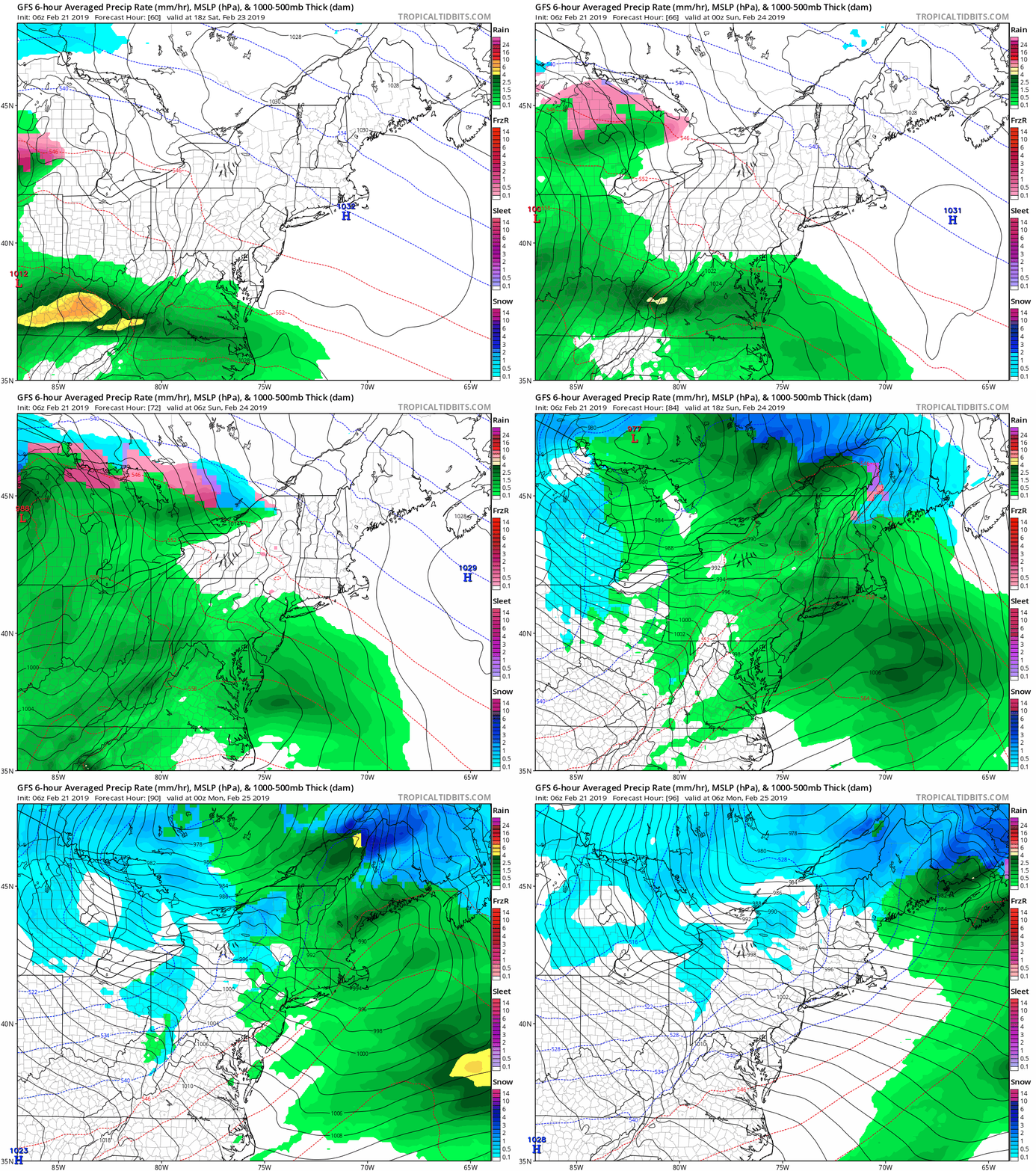
This weekend will start off dry, but end wet. Clouds will thicken on Saturday and showers will arrive by Saturday evening. Moderate to heavy rain through Sunday morning.
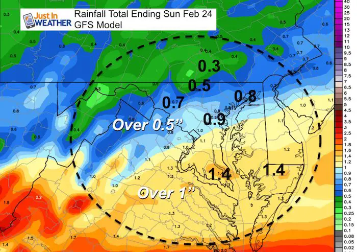
Weekend Rainfall
- The bulk of the rain will be in Southern Maryland with over 1 inch.
- Central Maryland will get over 1/2 an inch. Less rain expected farther north.

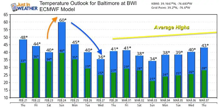
Temperature Outlook
Temperatures will drop over the next two days, then warm up with the rain storm Sunday. the overall pattern seems to be dominated by cooler temperatures through the first week of March. There is still more winter ahead of us.

ALL FITF Apparel
Please share your thoughts, best weather pics/video, or just keep in touch via social media
-
Facebook: Justin Berk, Meteorologist
-
Twitter: @JustinWeather
-
Instagram: justinweather
Related Links:
Winter Outlook
My Winter Outlook 2018-19: Multiple Nor’Easters and more snow
Interactive Snow Report
November 15 Snow Reports- Interactive Map Compared To My Forecast
Winter Snow And Top 5 Wet Years
Snowfall Seasons at Beginning and End of Top 5 Wet Years In Baltimore
Related Winter Outlooks
Solar Cycle: When Sun Spots Are Low We Get More Snow
El Nino Modoki May Enhance Snow Chances
Sweet Spot: Hitting 70ºF on Halloween is followed by more winter snow
Will A Wet Summer Bring A Snowy Winter?
NOAA Winter 2018-2019 Outlook Explained: This Actually Supports Snow
Winter Outlook From Two Different Farmers Almanacs
Maryland Winters: Snowfall Maps and Baltimore Snow History


