Monday Evening Update January 28 2019
New information in this post might be good news for some snow lovers. The Winter Weather Advisory has two updates in central Maryland. The timing has been expanded to now begin at 4 AM. This fits with my early forecast for predawn snow an proven in the new HRRR Model simulation slider below. The advisory also now includes Washington County, Maryland. So Hagerstown has joined the party and is now included in this map.
The other update is the National Weather Service snow forecast increased for some areas. I am keeping my original forecast and you can compare them all below. The big winner might be between northern Carroll County into York and Lancaster Counties.
Winter Weather Advisory

Zones Explained
1 AM Tue to 1 AM Wed for Southern Pennsylvania:
Adams, York, and Lancaster… This area will stay below freezing for the entire event.
4 AM Tue to 9 PM Tue for Counties:
Washington-Frederick MD-Carroll-Northern Baltimore-Northwest Montgomery-
Northwest Howard-Northwest Harford
This area will have some snow and ice in the morning and more snow total with the afternoon round.
Noon Tue to 10 PM Tue for Counties:
Southern Baltimore-Central and Southeast Montgomery-
Central and Southeast Howard-Southeast Harford-
Prince William/Manassas/Manassas Park-Fairfax-Northern Fauquier-
Southern Fauquier-Western Loudoun-Eastern Loudoun-
This area may have some wintry mix in the morning. But should thaw, then turn back to snow noon to 2 PM. Roads will become icy.
3 PM to Midnight Wed for Counties:
District of Columbia-Prince Georges-Anne Arundel-Charles-
Arlington/Falls Church/Alexandria-Stafford-Spotsylvania-
This area will turn to snow mid afternoon and get stickage on the roads for the afternoon commute. Travel will be icy into the evening.
4 AM to Midnight Wed for Counties:
New Castle-Cecil-Somerset-Mercer-Delaware
This area should stay below freezing for most or all of the event. Some morning snow, then the harder hit will be afternoon and evening.
Get Your Snow Day Kit
Help bring on your snow day with all of the local rituals all in one awesome FITF bag.
Each item is now available by itself. Click the image to see more.

Snow Simulations
Morning Timeline HRRR –> slider
[metaslider id=72119]
Notice the last image at noon. This model shows more mixing but has trouble identifying the snow.
Compare this to the NAM 3 Km Model… Showing more snow, but also having a hard time pushing it east for a few hours. This may be a signal that Low Pressure along the front is slowing it down. But, it may also be adding moisture.
Afternoon and Evening Timeline NAM 3 Km –> slider
[metaslider id=72096]
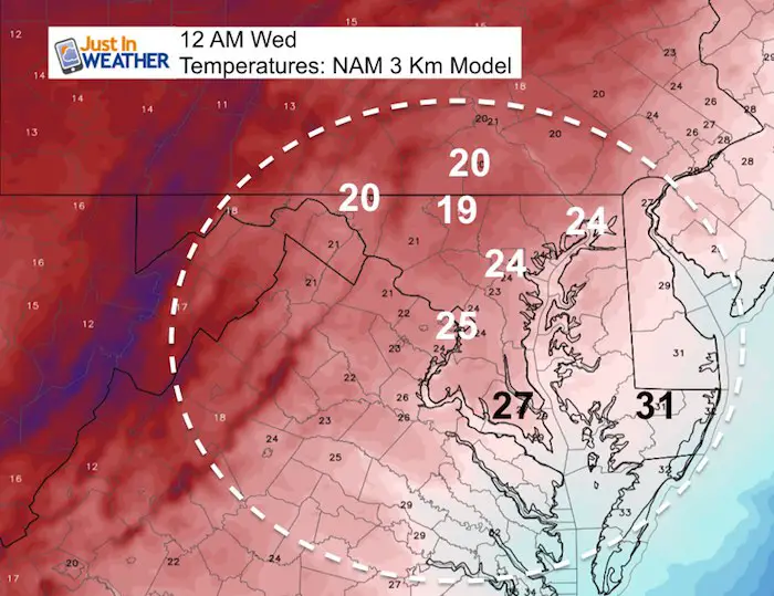
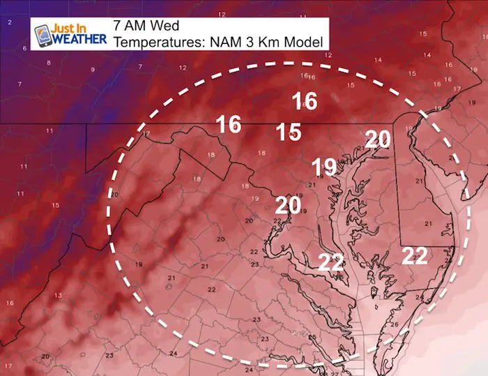
Flash Freeze: Cold Air To Follow
Midnight Wednesday
Wednesday Morning
How Much Snow?
NAM 3 Km Snow Forecast

NWS Office Snow Forecasts
The Baltimore/Washington Office increased the snow for northern Carroll County. Compare to the Pennsylvania Office just over the line almost half the total. That can be confusing. I think there is upside potential, but I am keeping my original forecast. Compare that below.

Westminster/Northern Carroll County is showing in 4 to 6 inches
But the image below has nearby
Adams and York Counties in PA is showing 2 to 3 inches

Cecil County shows a range of 2 to 4 inches. Less south in Kent County/Chestertown.

My Original Forecast
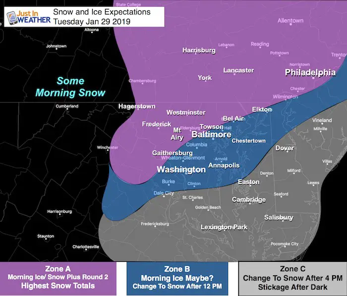
There will be some morning snow in the mountains. But the developing situation will be over our central are to the Delmarva.
Zone A:
- Most likely to have morning impact, stay near or below freezing all day, and have the most snow.
- Snow Totals: 2 to 4 inches. There is potential for some higher amounts.
Zone B:
- Marginal risk for morning issue on the roads.
- Thaw mid day, then change to snow between noon and 4 PM
- Snow Totals: 2 to 3 inches
Zone C:
- No morning weather problems
- Change to snow after 4 PM
- Wet roads will get stickage and turn icy of the evening
- Snow Totals: Up to 2 inches
Will We See Record Cold?
Temperature Outlooks
Let’s first take a look at some climate date for Baltimore at BWI for next week:
January 30 (Wed):
42ºF = Normal High; 25ºF = Normal Low
16ºF in 1966 = Record Cold Max Temperature *(likely to be a little higher than this)
-4ºF in 1873 = Record Min Temperature *(should not reach this level)
January 31 (Thur):
42ºF = Normal High; 25ºF = Normal Low
22ºF in 1948 = Record Cold Max Temperature *(Chance to break this)
+4ºF in 1966 = Record Min Temperature *(Chance to break this)
Keep In Touch Every Day
Just in case you don’t get all posts on your social media feed, stay up to date with the latest info…
Click here to sign up for email alerts…. Be the first to hear any new weather.
Please share your thoughts, best weather pics/video, or just keep in touch via social media
-
Facebook: Justin Berk, Meteorologist
-
Twitter: @JustinWeather
-
Instagram: justinweather
FITF and SnowStix

FITF Hats
After selling out twice, the hats are restocked and ready to ship.

Related Links:
Winter Outlook
My Winter Outlook 2018-19: Multiple Nor’Easters and more snow

Interactive Snow Report
November 15 Snow Reports- Interactive Map Compared To My Forecast

Winter Snow And Top 5 Wet Years
Snowfall Seasons at Beginning and End of Top 5 Wet Years In Baltimore

Related Winter Outlooks
Solar Cycle: When Sun Spots Are Low We Get More Snow
El Nino Modoki May Enhance Snow Chances
Sweet Spot: Hitting 70ºF on Halloween is followed by more winter snow
Will A Wet Summer Bring A Snowy Winter?
NOAA Winter 2018-2019 Outlook Explained: This Actually Supports Snow
Winter Outlook From Two Different Farmers Almanacs
Maryland Winters: Snowfall Maps and Baltimore Snow History
