Sunday December 30 2018
This morning actually had flurries and light snow, just north near York and Lancaster in PA. This weak system is helping to enhance our cloud cover this morning. After some breaks, more clouds will return and make it feel even chillier for the Ravens last regular season football game. I have the evening temperatures break down for the game below.
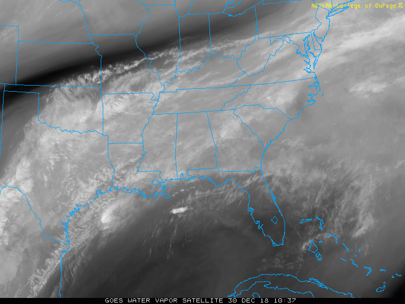
The larger moisture plume in the Deep South is where our last frontal boundary stalled and a new storm will be building and heading back our way. We are still in for a wet end to the year and it may affect your New Years Eve plans.

Water Vapor Satellite Loop
Local Weather Stats For December 30 in Baltimore
Average High: 42ºF
Record High: 68ºF in 1990
Average Low: 25ºF
Record Low: -33ºF in 1880
*Record Snow: 2.3″ in 1935
Sunrise: 7:25 AM
Sunset 4:52 PM
*Daylight = 0:31 longer than yesterday
*Bay Water Temperature = 43ºF at Thomas Pt. Light House
Morning Temperatures

Temperature Timeline: Ravens Game —> slider
[metaslider id=70183]
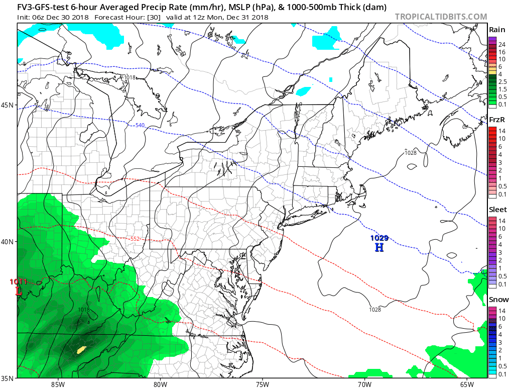
Rain Animation: New Year’s Eve
The rain will arrive before noon for most of us, and come in waves through midnight. There may be a few hours with just a few showers, but the chance of it being wet at midnight is pretty high. Then the rain will move away New Year’s Day morning.
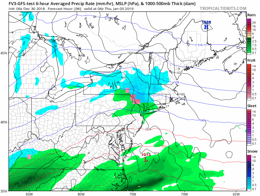
Next Event Thursday
Once again a system that might have produced snow, is now expected to take a track farther west and bring us rain. I have little confidence it any computer model beyond days…. So I will be caution in trusting any long range outlook in the new year. Be cautious what you read on other blogs.
The snow may be just inland along the mountain ridges.
Temperature Outlook
The roller coaster continues with the trend of warm air following a rain event, then cooling down. The first cold snap (as discussed a few days ago) will be this weekend. Then we should transition back to a colder winter pattern for the eastern US for the middle and second half of January.

Snow Day Kit
Our ritual the night before a storm is finally in one kit. Maybe if more Maryland kids had this, the storm would reach us 🙂
- This includes a very soft raglan Tee printed inside out with #FITF AND the check list, #FITF spoon for under your pillow, ice cube tray with snowflake shapes, chalk, a #FITF wrist-band, a mini SnowStix, and a bag to carry it all in.
- New Orders are likely to be delivered after the holiday.
- This will also help us give a free Snow Day Kit to each of the Just In Power Kids.

FITF and SnowStix Stores are now OPEN

Keep In Touch Every Day
Click here to sign up for email alerts…. Be the first to hear the big news over the weekend
Also- Just in case you don’t get the post on your social media feed
Please share your thoughts, best weather pics/video, or just keep in touch via social media
-
Facebook: Justin Berk, Meteorologist
-
Twitter: @JustinWeather
-
Instagram: justinweather
Keep In Touch Every Day
Click here to sign up for email alerts…. Just in case you don’t get the post on your social media feed
Related Links:
Winter Outlook
My Winter Outlook 2018-19: Multiple Nor’Easters and more snow

Interactive Snow Report
November 15 Snow Reports- Interactive Map Compared To My Forecast

Winter Snow And Top 5 Wet Years
Snowfall Seasons at Beginning and End of Top 5 Wet Years In Baltimore

Related Winter Outlooks
Solar Cycle: When Sun Spots Are Low We Get More Snow
El Nino Modoki May Enhance Snow Chances
Sweet Spot: Hitting 70ºF on Halloween is followed by more winter snow
Will A Wet Summer Bring A Snowy Winter?
NOAA Winter 2018-2019 Outlook Explained: This Actually Supports Snow
Winter Outlook From Two Different Farmers Almanacs
Maryland Winters: Snowfall Maps and Baltimore Snow History

Snowstix- We Need You To Measure Snow Too
We are giving 10% of each sale to Just In Power Kids: Providing FREE holistic care for pediatric oncology patients.
