Sunday November 18 2018
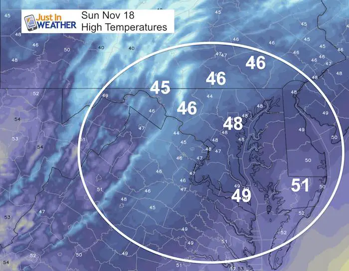
Today will be quiet and mild, which is great news in Baltimore for the Ravens game. Then we shift our focus to the Thanksgiving week that will feature a lot of changes. The first system on Monday night wil be benign with light rain, but you may run into snow near State College PA. Then temperatures TANK on Thanksgiving. Turkey Trot runs in the morning will be in the 20s for many and the afternoon will struggle to reach freezing around the cities. At least cooking in the oven or lighting up the fireplace will be justified to warm the house.
The next event will be Thanksgiving weekend. At this time models are showing rain, but I hesitate to confirm as cold air has tended to hang on longer. There will be a developing storm on the east coast that should start with us on the warm end… But signals pointing to a major pattern change beginning then and lasting into the start of December.
Local Weather Stats For November 18 in Baltimore
Average High: 56ºF
Record High: 78ºF in 1938
Average Low: 36ºF
Record Low: 20ºF in 1959
*Record Snow: Trace in 2008
Sunrise: 6:53 AM
Sunset 4:49 PM
*Daylight = 1:48 shorter than yesterday
*Bay Water Temperature = 48ºF at Thomas Pt. Light House
Just In: #FITF Hats

Keep In Touch Every Day
Click here to sign up for email alerts…. Just in case you don’t get the post on your social media feed
The FITF Store Is Open With Gear And SnowStix
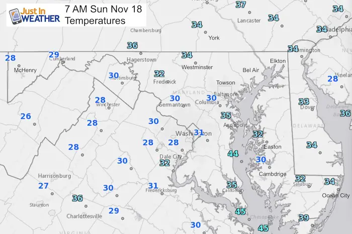
Morning Temperatures
Sunday Afternoon High Temperatures
Monday-Tuesday —> slider
Light rain with snow in central PA
[metaslider id=68591]
Temperature Outlook
Very Cold Thanksgiving Then Pattern Change
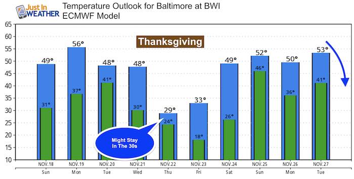
Both Thanksgiving Thursday and Black Friday look. dry cold. A mild trend ahead of the next storm is why we expect RAIN over the holiday weekend. That coastal storm looks warm here, but it will be a game changer…
Thanksgiving Weekend Storm —> slider
[metaslider id=68610]
Outlook
The North Atlantic Oscillation (NOA) is and index I discussed in my winter outlook. This is a measure of the pressure pattern in the North Atlantic that can play a big role in our weather on the US east coast. A negative value will translate to stormy and colder weather … often. So check out the long range projections on the Euro and GFS (America) Models.
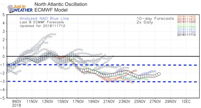
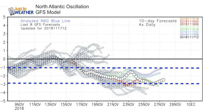
Both stay in the rand of -1 to -3, which is why I mentioned this last night. There is a lot of hype in the weather community about the potential for one or multiple storms between the week AFTER Thanksgiving and early December
Please share your thoughts, best weather pics/video, or just keep in touch via social media
-
Facebook: Justin Berk, Meteorologist
-
Twitter: @JustinWeather
-
Instagram: justinweather
Keep In Touch Every Day
Click here to sign up for email alerts…. Just in case you don’t get the post on your social media feed
The FITF Store Is Open With Gear And SnowStix
Related Links:
Winter Outlook
My Winter Outlook 2018-19: Multiple Nor’Easters and more snow

Interactive Snow Report
November 15 Snow Reports- Interactive Map Compared To My Forecast

Winter Snow And Top 5 Wet Years
Snowfall Seasons at Beginning and End of Top 5 Wet Years In Baltimore

Related Winter Outlooks
Solar Cycle: When Sun Spots Are Low We Get More Snow
El Nino Modoki May Enhance Snow Chances
Sweet Spot: Hitting 70ºF on Halloween is followed by more winter snow
Will A Wet Summer Bring A Snowy Winter?
NOAA Winter 2018-2019 Outlook Explained: This Actually Supports Snow
Winter Outlook From Two Different Farmers Almanacs
Maryland Winters: Snowfall Maps and Baltimore Snow History

Snowstix- We Need You To Measure Snow Too
We are giving 10% of each sale to Just In Power Kids: Providing FREE holistic care for pediatric oncology patients.
