 Wednesday November 14 2018
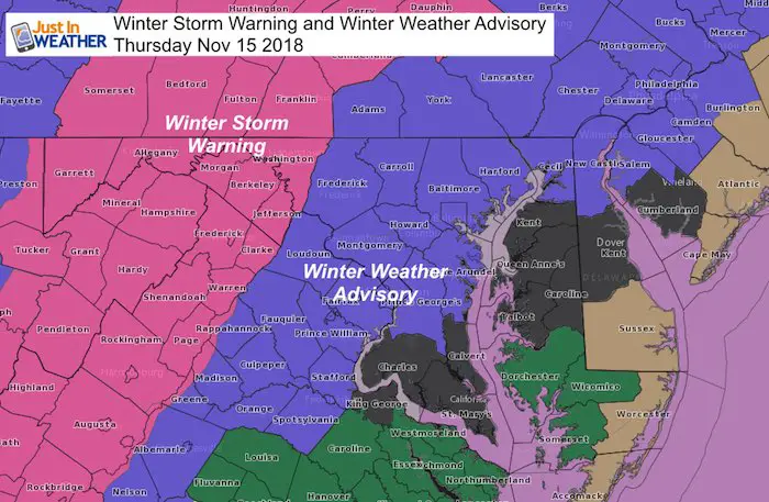
The storm arriving on Thursday morning will bring our first taste of winter to the Mid Atlantic. A Winter Weather Advisory has been issued for most of central Maryland, southern PA, and northern VA, along with northern Delmarva. There will be a mix of snow, sleet and rain in the morning. There could be a period of moderate snow that will stick. Below is a break down of who may get it on the roads.
A Winter Storm Warning has been issued for western Maryland. This also includes the mountains of Virginia to WV, and on the north side long I-81 to Harrisburg PA. These areas will stay mostly snow or ice and problems will last into Friday morning.
School Call?
- I DO NOT give suggestions on schools. They make their call and sometimes it can be surprising. Even those I work with.
- No School should or would make a call tonight. It is too early to see how this will play out. But I would pay attention in morning. Any adjustment of the arrival may impact bus travel.
I have a lot of info and I know most will see this on a phone, so I want to limit the verbiage… So please play along with the bullet points.
This maps shows it best:
This is an afternoon snapshot form the European Model. I will show the timeline arrival below…
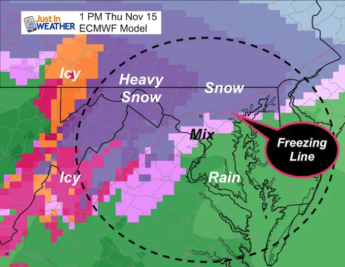
Note where the Freezing Line is forecast at 1 PM. That is northwest of I-95 and in almost the same location as daybreak! Snow and sleet to the south will fall, but a big question what will stick.
Keep In Touch Every Day
Click here to sign up for email alerts…. Just in case you don’t get the post on your social media feed
The FITF Store Is Open With Gear And SnowStix
I will be launching two new items today and tomorrow. But the weather forecast is more important now
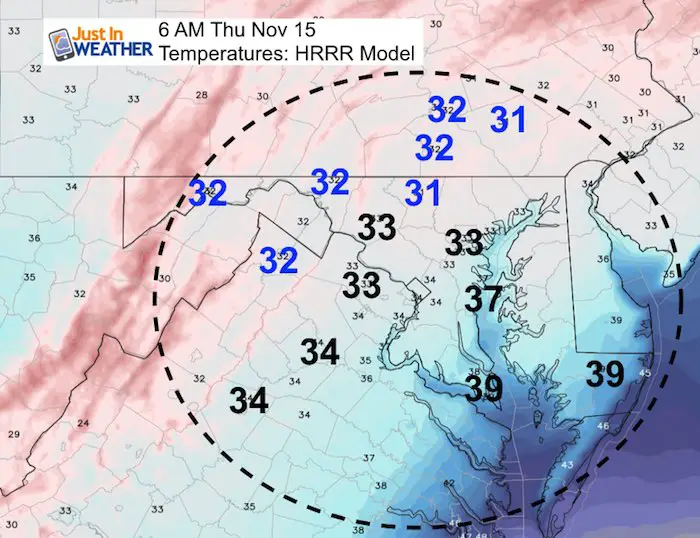
Morning Temperatures
- These are the predicted numbers around the time the storm rolls in…
- Many of these areas will hold within a degree above or below freezing into the afternoon.
- Some areas may get a little colder after the precipitation begins.
- Snow and sleet can fall from colder clouds when the ground temps are warmer. Then stickage comes into question.
- I do question the advisory in some southern counties as I don’t see temperatures dropping cold enough, plus a faster change over to rain
Things to keep in mind
- Sun today warmed the pavement and some of that heat will be retained.
- Water temps on the Bay are in the 50s. Places near the water will be warmer, so I think snow stickage will have a hard time here. Especially on the pavement.
- We have not been below freezing for a few days. Temps tonight will be close, but is it enough to chill the ground?
- Rain, sleet, and snow will move in early in the morning: It will get heavy for a few hours. That could allow for the flakes to cool the ground for stickage, but it will be slushy.
- Elevation will play a big roll. Places inland and higher up will get more snow to lay and stay (stickage).
Snow Arrival Timeline –> HRRR Model
There will be rain and snow on radar early in the morning. I hesitate to promote this all as falling since the initial stuff may be virga (dry up on the way to the ground).
[metaslider id=68389]
How Much Will We Get?
Here is my final forecast. Compare to the models below.
Please note the legend at the bottom:
Metro areas will be mostly on the grass…
But some of northern Hartford, Baltimore, and Carroll Counties may get slick roads at times when snow is heaviest.
The best chance for road issues will be in the purple and gray zones. Travel may be slick there, but the arrival will be during or just after the school busses. The will be a tough call.

Compare Other Forecasts
National Weather Service, European ECMWF, GFS, NAM, and Canadian maps are posted below.
National Weather Service – The doesn’t seem to fit with the Advisory Map.
I noted the temps above freezing below… Here shows no snow south of Baltimore/I-95. Snow and sleet falling will lower visibility for a few hours in the morning though.

European ECMWF– I think this is WAY TOO AGGRESSIVE! I can NOT endorse this forecast with the high numbers in northern MD or southern PA.
This model is great for storms but overdoes snow projections often

GFS– I am sorry this product cut of around the Bay. It does show a coating to 1 inch across metro Baltimore, Washington, and Annapolis. But mostly on the grass!
NAM 3 Km – This is a little lower than the GFS Model and may have accounted more for sleet and melting.

Canadian GEM – This shows the sharp drop near and south of I-95. There is a dramatic increase in the all snow areas and this may be overdone.

Ending As Snow?
The same color areas north of Baltimore that thaw later, may return to snow as this storm ends early Friday morning.

Winter Outlook
My Winter Outlook 2018-19: Multiple Nor’Easters and more snow

Related Winter Outlooks
Solar Cycle: When Sun Spots Are Low We Get More Snow
El Nino Modoki May Enhance Snow Chances
Sweet Spot: Hitting 70ºF on Halloween is followed by more winter snow
Will A Wet Summer Bring A Snowy Winter?
NOAA Winter 2018-2019 Outlook Explained: This Actually Supports Snow
Winter Outlook From Two Different Farmers Almanacs
Maryland Winters: Snowfall Maps and Baltimore Snow History

FITF and SnowStix Stores are now OPEN

Snowstix- We Need You To Measure Snow Too
We are giving 10% of each sale to Just In Power Kids: Providing FREE holistic care for pediatric oncology patients.

Keep In Touch Every Day
Click here to sign up for email alerts…. Just in case you don’t get the post on your social media feed
Please share your thoughts, best weather pics/video, or just keep in touch via social media
-
Facebook: Justin Berk, Meteorologist
-
Twitter: @JustinWeather
-
Instagram: justinweather