Tuesday September 11 2018
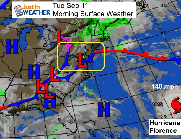
Hurricane Florence is holding at 140 mph winds and now showing up on the edge of our water map. In addition to the States of Emergency from Maryland down through South Carolina, not Hurricane Watches and Storm Surge Watches have been issues. More on that and our local expectation below. But first, we have thick fog this morning and some showers and storms this afternoon not connected to the hurricane.
Local Weather Stats For September 11 in Baltimore
Average High: 80ºF
Record High: 100ºF in 1983
Average Low: 60ºF
Record Low: 43ºF in 1917
Sunrise: 6:44 AM
Sunset 7:21 PM
*Daylight = 2:31 shorter than yesterday
*Bay Water Temperature = 76ºF at Thomas Pt. Light House
Also see: Winter Outlook From Two Different Farmers Almanacs
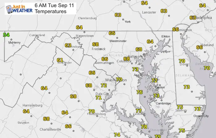
Morning Temperatures
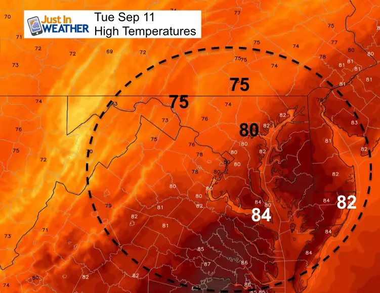
Afternoon Temperatures
Radar Simulation –> slider
Best chance for storms will be after 2 PM from I-95 east to Delmarva
[metaslider id=65391]
Rain Animation:
We will remain on the edge of this fading front and the northern fringe of Hurricane Florence. The bulk, of that rain will stay just south but throw some rain bands our way. This is the outlook from the ICON Model
![]()
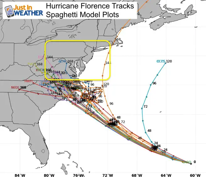
Hurricane Florence Update
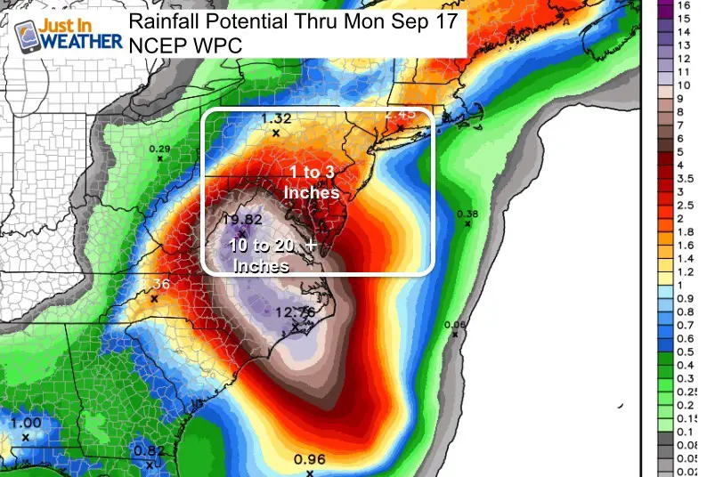
While winds remain at 140 mph, there is a chance this reaches Category 5 briefly today. The track is still locked in on North Carolina… then expected to stall or crawl inland. That wil determine if rain can reach Maryland and in the path who may get 10, 20, or even up to 30 inches of rain.
Infrared Stellite This Morning

Wider View
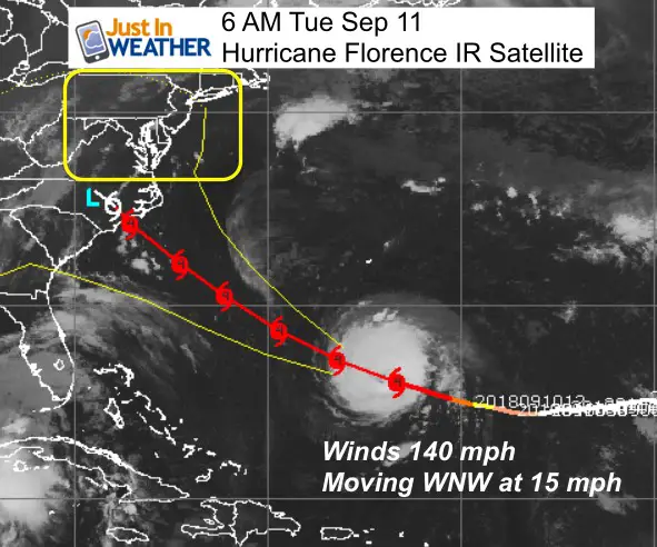
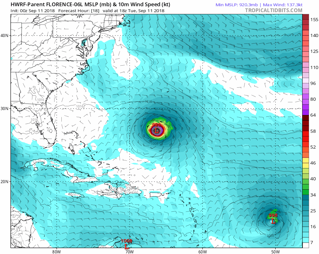
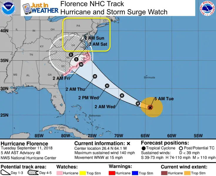
SUMMARY OF 500 AM AST...0900 UTC...INFORMATION
----------------------------------------------
LOCATION...26.4N 64.1W
ABOUT 410 MI...660 KM S OF BERMUDA
ABOUT 975 MI...1570 KM ESE OF CAPE FEAR NORTH CAROLINA
MAXIMUM SUSTAINED WINDS...140 MPH...220 KM/H
PRESENT MOVEMENT...WNW OR 290 DEGREES AT 15 MPH...24 KM/H
MINIMUM CENTRAL PRESSURE...944 MB...27.88 INCHES
Forecast Maps
The cluster shows landfall between Wilmington and Cape Hatteras NC
Storm Animation
HWRF Shows Hurricane Florence making landfall just north of Wilmington and then nearly stalling for two days, then pushing west. That could dump over 20 inches of rain there and limit the impact north into Maryland.
Storm Surge And Hurricane Watches from South Carolina To VA Border
A Storm Surge Watch has been issued for the east coast of the
United States from Edisto Beach, South Carolina northward to
the North Carolina-Virginia border, including the Pamlico and
Albemarle Sounds.

A Hurricane Watch has been issued for the east coast of the United
States from Edisto Beach, South Carolina, northward to the
North Carolina-Virginia border, including the Pamlico and Albemarle
Sounds.
What About Maryland?
The track of Florence is similar to Isabel (2003), but instead of moving inland in a hurry, this will crawl or stall. That may limit the surge of water up the Chesapeake Bay, but water levels are already high with flooding. There wil be more flooding as tides will not be allowed to drain out. Watching if and where this crawls will determine how much water may or may not push north. We are on the edge.
Winds: Southern Maryland and Ocean City may get gusts to 35 mph, but the bulk of the storm impact will remain south.
Rain: Depending on the craw and stall, the edge of the rain bands will clip our region with some areas near and north of Baltimore possibly staying dry. In fact the sinking air around the edge of the storm on Thursday might make it nice briefly before the east winds brings back the moisture. We will be in for a chance of rain through next week.
Love Maryland Shirt Designed By Jaiden
 |
|
This shirt was designed by my ‘bonus’ daughter Jaiden. All proceeds will go to Just In Power Kids and free holistic therapy for kids in and post cancer treatment.
Show your love for Maryland and make this 14 year old artist extra proud
|
Keep In Touch Every Day
Click here to sign up for email alerts…. Just in case you don’t get the post on your social media feed
Please share your thoughts, best weather pics/video, or just keep in touch via social media
-
Facebook: Justin Berk, Meteorologist
-
Twitter: @JustinWeather
-
Instagram: justinweather
Now Scheduling School Assemblies
- Storm Smart – Severe Weather (September, October; March through May)
- FITF – Snow and ice (November through March)
Programs for K through Middle School
Choose flat fee or FREE along with a spirit wear shirt fundraiser that earns your school money.
Power Partner Just In Power Kids and Maryland Trek 5:

Still Time To Support Just In Power Kids
We are still taking donations for our best Maryland Trek yet. Every penny goes to Just In Power Kids programs to provide FREE holistic care for kids in cancer treatment and up to 5 years post treatment.
![]()
 Get the award winning Kid Weather App I made with my oldest son and support our love for science, weather, and technology. Our 3 year anniversary of the release and our contribution to STEM education is this November. It has been downloaded in 60 countries, and works in both temperature scales. With your support we can expand on the fun introduction to science and real weather.