Sunday June 10 2018
The morning sky is filled with clouds and the air is heavy with humidity. But the source of energy for the next round of rain is still to our northwest. This is the reason I was hesitant to suggest any change for your weekend plans. We will have rain and more storms. But, the timing and location are different than what models had suggested just to days ago. So instead of morning rain clearing, we will have a repeat of afternoon and evening strong storms. We also need to take a hint from Ocean City, where a staled thunderstorm yesterday led to between 6 and 8 inches of rain and major flooding. The problem with long duration or repeating storm cells today may be between Baltimore, Harford, and Cecil County in Maryland… plus York and Lancaster counties in PA.
The radar simulation below is just a suggestion, so give it some wiggle room. That means the timing could be off by an hour or so and the location of the cells may be within a 30 to 50 mile range. IONce they develop, we can fine tune the track. But here we see southern PA with rain mid day, and the spread into central Maryland by this evening. The heaviest storms around metro Baltimore/Washington/Annapolis could be between 8 PM and midnight.
Stats For June 10 in Baltimore
Note: June 5th was the earliest date on record that Baltimore has broken 100 degrees, back in 1925
Average High: 82ºF
Record High: 97ºF in 1964
Average Low: 60ºF
Record Low: 49ºF in 1960
Sunrise: 5:39 AM
Sunset 8:32 PM
*Daylight = 0:38 longer than yesterday
*Bay Water Temperature = 72ºF at Thomas Pt. Light House
Keep In Touch Every Day
Click here to sign up for email alerts…. Just in case you don’t get the post on your social media feed
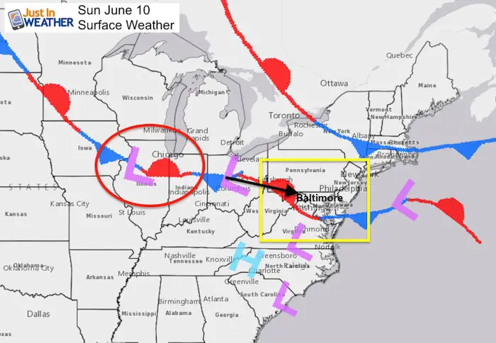
Morning Set Up
Morning Weather Map
Compare this map to the satellite loop below. The complex near Chicago is the core of the upper level energy, but responsible for sending clouds and spokes of energy our way…
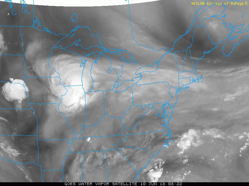
Satellite Loop (4 Hours)
Mesoscale Convective Complex
The mass of clouds near Chicago is the concentration of the bulk of the energy. This core zone was supposed to shift to the east, but has remained in place most of the weekend. That will continue to send more clouds and high level moisture downstream our way.
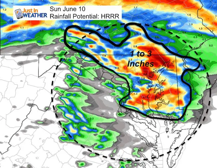
Rain Potential
I am showing this before the radar simulation so you can see the focus of heavy rain. The heaviest may be around and on the northeast side of Baltimore. Individual cells and the speed of the movement may determine locally heavy rain and flooding potential.
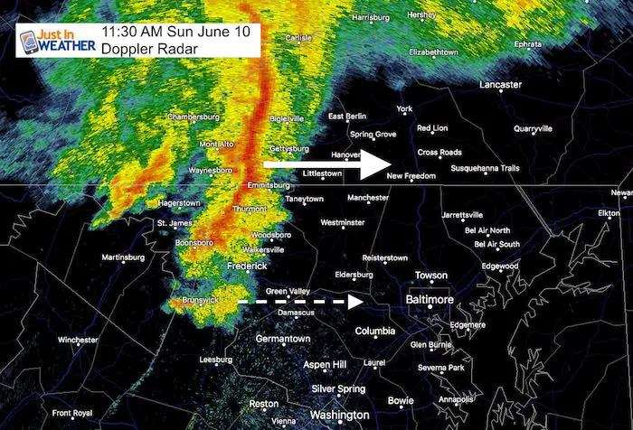
Update at 11:30 AM
This Doppler Radar image was more intense and showed the line of rain farther south than this simulation. We need to keep adjusting or nowcasting for the day as models are missing some energy aloft.
Radar Simulation —> slider
[metaslider id=63097]
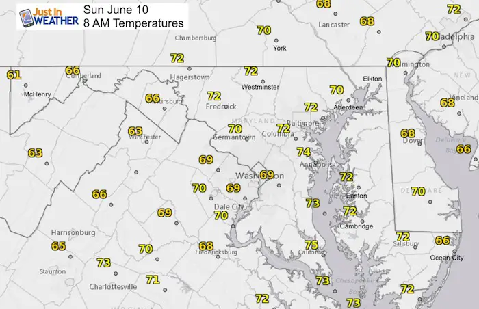
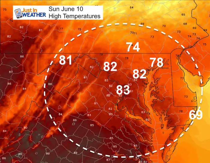
High Temperatures
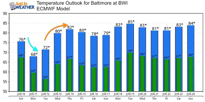
Temperature Outlook
Shine On
Proceeds from all sales go to Just In Power Kids. Click the image to shop and show your support.

![]()
Please share your thoughts, best weather pics/video, or just keep in touch via social media
-
Facebook: Justin Berk, Meteorologist
-
Twitter: @JustinWeather
-
Instagram: justinweather
Keep In Touch Every Day
Click here to sign up for email alerts…. Just in case you don’t get the post on your social media feed
 Get the award winning Kid Weather App I made with my oldest son and support our love for science, weather, and technology. Our 3 year anniversary of the release and our contribution to STEM education is this November. It has been downloaded in 60 countries, and works in both temperature scales. With your support we can expand on the fun introduction to science and real weather.