 Saturday May 5 2018
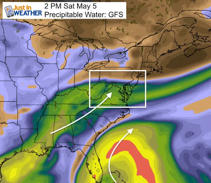
Today earthquakes and a volcanic eruption rage on Hawaii, it is the Kentucky Derby, and Cinco de Mayo there is so much to focus on. But the end of our heat wave and rain on the weekend is the purpose here. Baltimore hit 91ºF on Friday making three days in a row with new record highs. Now we settle back closer to normal as the wet pattern is closing in. Some rain this morning has already fallen, but the map shows a wet pattern. This image is the Precipitable Water in the atmosphere which makes it easier to see the moisture from the southeast US in addition to a quasi-tropical set up off of the southern Florida coast. This is how it will play out… AS rain will try to build in today and showers linger on Sunday.
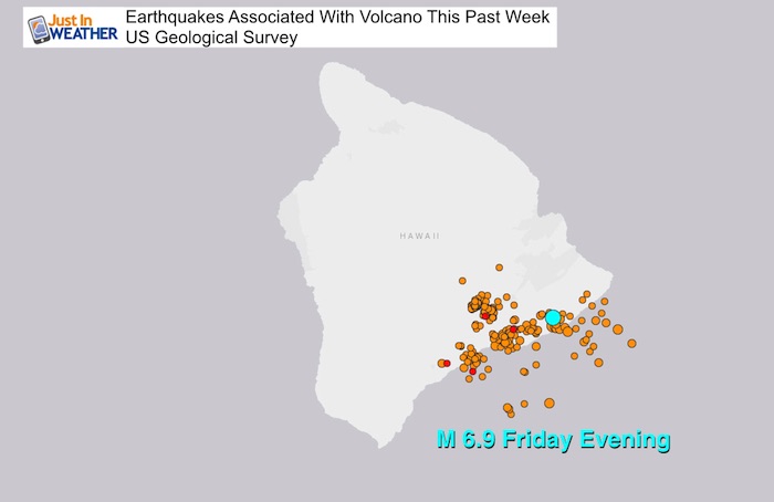
Largest Earthquake in 40 years
The M 6.9 quake that hit Hawaii on Friday evening was the largest on the island in 40 years. This is all associated with the eruption of the Kilauea Volcano
Stats For May 5 in Baltimore
Average High: 71ºF
Record High: 92ºF in 1930
Average Low: 49ºF
Record Low: 34ºF in 1966
Sunrise: 6:03 AM
Sunset 8:03 PM
*Daylight = 2:07 longer than yesterday
*Bay Water Temperature = 58ºF at Thomas Pt. Light House
Keep In Touch Every Day
Click here to sign up for email alerts…. Just in case you don’t get the post on your social media feed
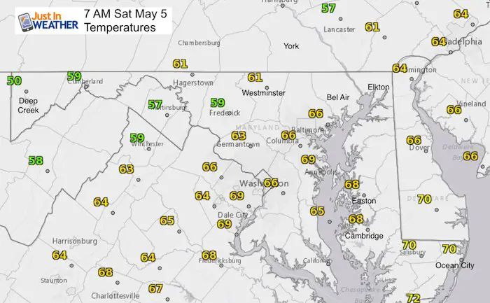
Morning Temperatures
Morning Weather Map
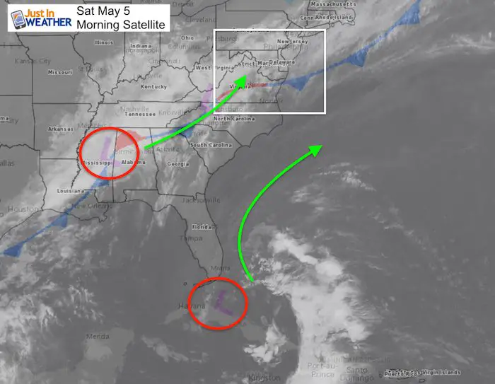
We are on the colder side of this cold front and a wave of Low Pressure will be riding along it. This will send rain back our way today. The wet times will be in the afternoon and tonight. Another feature off of the south Florida coast is pumping heavy topical moisture from the Bahamas. Parts of southeast Florida can get over 5 inches of rain. This should stay off of the coast, but stall our front…. keeping the rain chances around Sunday.
Simulated Radar Today —> slider
The high resolution model is most aggressive with the rain, while other models try to keep us dry until evening. I would consider the building chance of wet weather as we get into the afternoon, but Southern Maryland may remain dry.
[metaslider id=61684]
Precipitable Water Animation
This shows the moisture flow to give you the impressive of how these two system will flow over the next few days

Simulated Radar Sunday—> slider
Since the front is stalling thanks to the storm off of the coast, it is less active, but will keep the risk of showers around. This is a rough estimate of the rain plot. Not precise.
[metaslider id=61713]
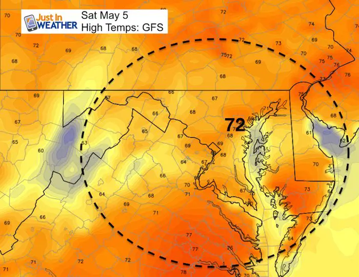
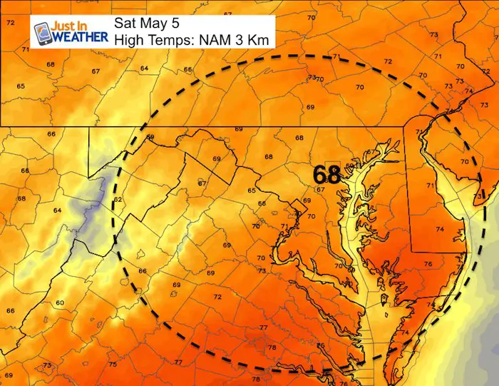
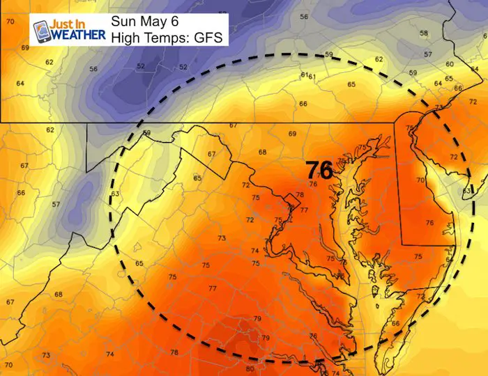
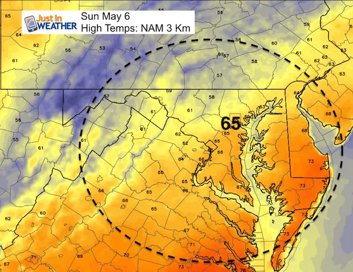
Temperatures
Note: We have already seen a high in the upper 70s at midnight. But the afternoon temps will depend on rain moving in…
Contrasting the range…
The GFS Model is warmer than the NAM 3 Km. Here is a contrast of both of them
Saturday
Sunday
There is a larger split tomorrow depending on the impact of clouds and rain with the stalled front. The guarantee is cooler temps than this past week, but the spread from mid 60s to mid 70s. Cooler where the rain falls.
![]()
Shine On
Proceeds from all sales go to Just In Power Kids. Click the image to shop and show your support.

Please share your thoughts, best weather pics/video, or just keep in touch via social media
-
Facebook: Justin Berk, Meteorologist
-
Twitter: @JustinWeather
-
Instagram: justinweather
Keep In Touch Every Day
Click here to sign up for email alerts…. Just in case you don’t get the post on your social media feed
 Get the award winning Kid Weather App I made with my oldest son and support our love for science, weather, and technology. Our 3 year anniversary of the release and our contribution to STEM education is this November. It has been downloaded in 60 countries, and works in both temperature scales. With your support we can expand on the fun introduction to science and real weather.