 Thursday April 19 2018
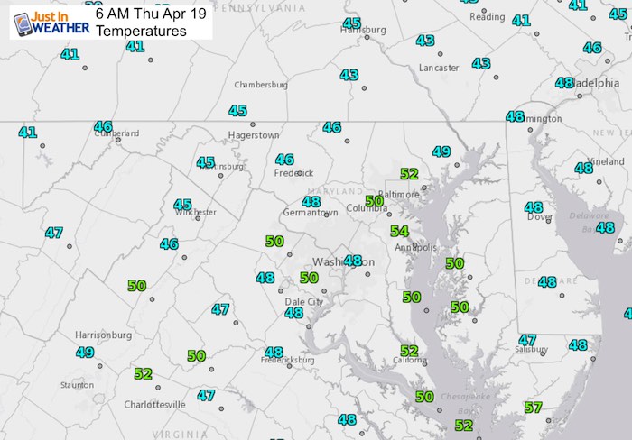
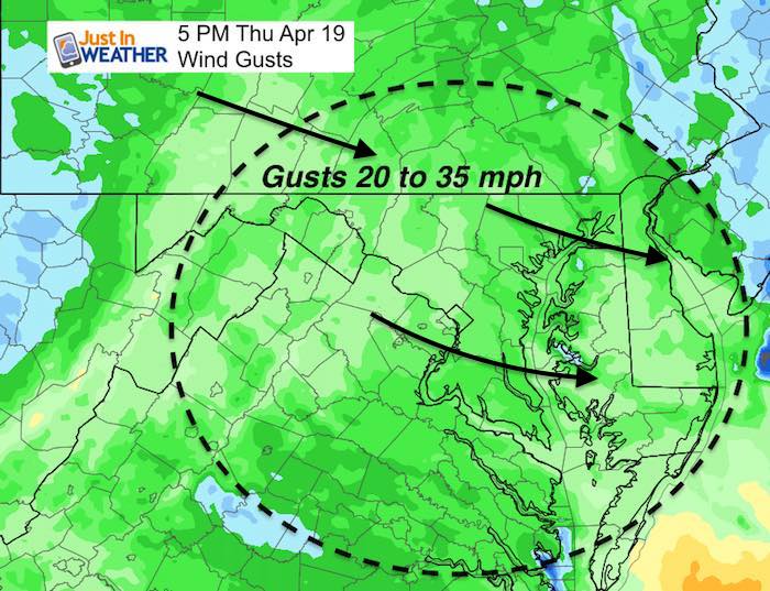
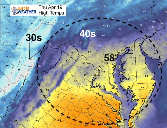
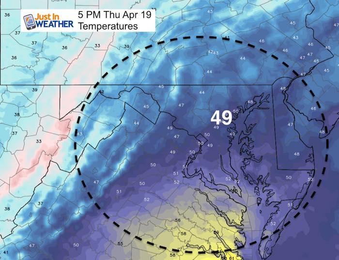
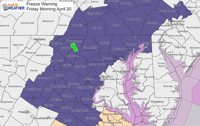
We have a relatively mild start with temperatures in the mid 40s to mid 50s. But this is the surge of air ahead of our next cold front. Showers will be moving through in a few pulses today, with he peak rain and temperatures around noon. Then strong colder winds will build in and drop the thermometer this afternoon. Gusts up to 35 mph and temps crashing through the 40s, and continuing to fall tonight. A Freeze Warning is once again in place for areas west of The Bay. This chilly outlook extends through next week.
Stats For April 19
Average High: 66ºF
Record High: 93ºF in 1896
Average Low: 44ºF
Record Low: 24ºF in 1875
Snow Record: Trace in 1983
Seasonal Snow To Date (at BWI): 15.2
Sunrise: 6:23 AM
Sunset 7:47 PM
*Daylight = 2:24 longer than yesterday
*Bay Water Temperature = 50ºF at Thomas Pt. Light House
Keep In Touch Every Day
Click here to sign up for email alerts…. Just in case you don’t get the post on your social media feed
Water Vapor Satellite Loop
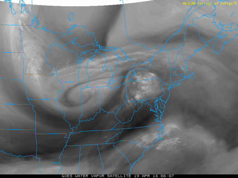
Check out the circulation entering Ohio this morning. That is a very potent upper level Low and was responsible for snow through the north central plains yesterday. We get mostly rain out of it, but snow will return with a few inches in Garrett County to Snowshoe, WV. This will kick up the winds and crash out temps this afternoon.
Radar Simulation —> slider
[metaslider id=61350]
Winds Peak Noon to 5 PM
High Temps Around Noon
Late Afternoon Temps
Low Temps Friday Morning
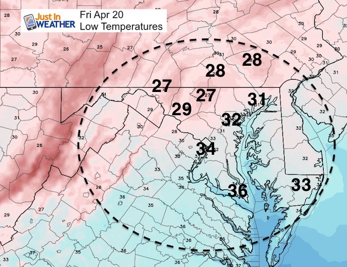
FREEZE WARNING FRIDAY MORNING
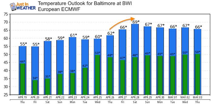
Temperature Outlook
Keep In Touch Every Day
Click here to sign up for email alerts…. Just in case you don’t get the post on your social media feed
![]()
Shine On
Proceeds from all sales go to Just In Power Kids. Click the image to shop and show your support.

 Get the award winning Kid Weather App I made with my oldest son and support our love for science, weather, and technology. Our 3 year anniversary of the release and our contribution to STEM education is this November. It has been downloaded in 60 countries, and works in both temperature scales. With your support we can expand on the fun introduction to science and real weather.
Also See:
My Winter Outlook 2017-2018 for more snow
La Nina Formed: What it could mean to our winter
NOAA Winter Outlook: Not The Best But Not The Worst For Snow
Two Farmers Almanacs Winter 2018 Outlooks
Winter Weather Folkore: Suggestions from Animals and Crops
First Frost and Freeze Dates For Maryland (southern PA and northern VA)
My Preliminary Winter Outlook Notes
Low Snow Winters In Baltimore: To Repeat Or Not Repeat
NOAA Ranks Blizzard 2016 4th Worst Snowstorm On Record