 Saturday September 9
Hurricane Irma briefly surges back to Category 5 overnight, but is back down this morning as the eye wall is scraping the northern edge of Cuba. The winds of 155 mph places it at the highest possible Category 4 thanks to interaction with land. But the turn to the north is expected to allow for some regeneration over the 90 miles of warm Florida Straights water. The main points to take away this morning: The storm is larger and the track is back again to the west side of Florida wth a direct hit on the Keys. This is farther away from Miami, but they are still in for a beating. 5.6 million people were part of the 2nd largest evacuation in US history. There are no winners but the losers are southwest Florida with maximum storm surge possible in and around Naples. This could be a serious threat now to Tampa as well.
Larger Storm
70 miles: Hurricane Force Wind Field
195 miles: Tropical Storm Force Wind Filed (390 miles across)
See More below:
- Satellite Animaton
- Forecast Maps and Animation
- Storm Surge Map
- Rainfall Map
- Track and Warnings
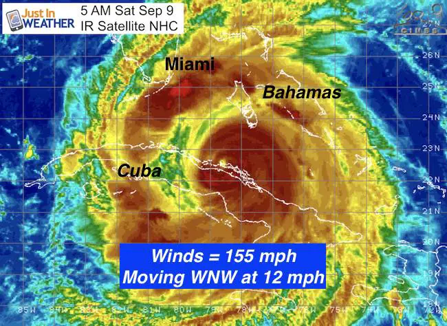
Storm Stats As of 5 AM
LOCATION…22.5N 78.8W
ABOUT 45 MI…70 KM E OF CAIBARIEN CUBA
ABOUT 245 MI…395 KM SSE OF MIAMI FLORIDA
MAXIMUM SUSTAINED WINDS…155 MPH…250 KM/H
PRESENT MOVEMENT…WNW OR 285 DEGREES AT 12 MPH…19 KM/H
MINIMUM CENTRAL PRESSURE…930 MB…27.47 INCHES
Satellite Animation
Tracking West
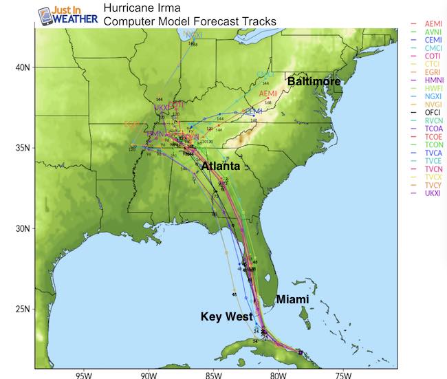
The initial forecast was for this to be on the east side of Florida, then it shifted west and I reported on Tuesday that this would hit the Keys instead. The forecast moved back to the east coast, only to trend west again. The retaining strength of the storm and the fact that it slowed down its forward movement to 12 mph helped determine the turn to the north being later.
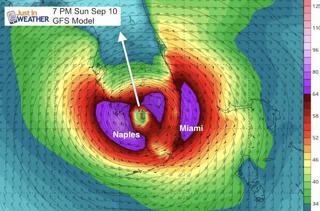
The GFS Model has been on point with the HWRF Model on the east end of the potential path. Here is the Sunday night view, west of Miami and very close to a direct hit on Naples. This is important to track the core of the fastest winds right at the eye way and the storm surge. But, this is only one solution.
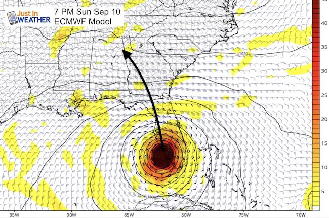
The European ECMWF is slightly farther west, tracking on the west side/Gulf Coast side of Florida
Forecast Animation
Note that this model is a little east of the center from the National Hurricane Center. But note the path west of Atlanta as a Tropical Storm and then into Tennessee as it dissipates.
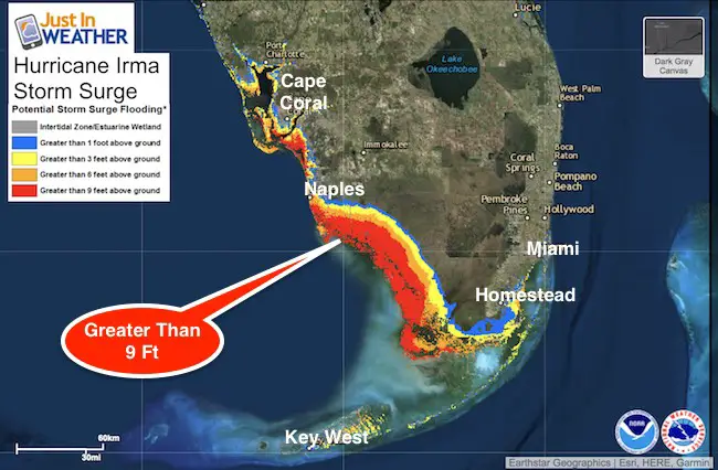
Storm Surge Warnings
The latest modeling shows 9 Ft + storm sure into Naples. The shape of the coast and the wind flow will pile more water in and make for nearly complete coastline devastation. The wall of water will push miles inland with unimaginable damage.
A Storm Surge Warning is in effect for…
* Volusia/Brevard County Line southward around the Florida peninsula
to Chassahowitzka
* Florida Keys
* Tampa Bay
A Storm Surge Watch is in effect for…
* North of the Volusia/Brevard County Line to the Flagler/Volusia
County line
* North of Chassahowitzka to Suwannee River
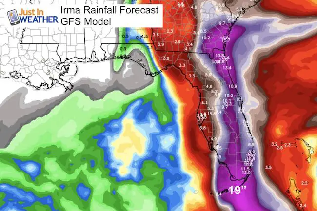
Rainfall
Top rain of 19 inches in the Keys. Note, this is from the GFS Model which is farther east. The can be shifted to the west coast and increase if this can tap into the Gulf of Mexico moisture.
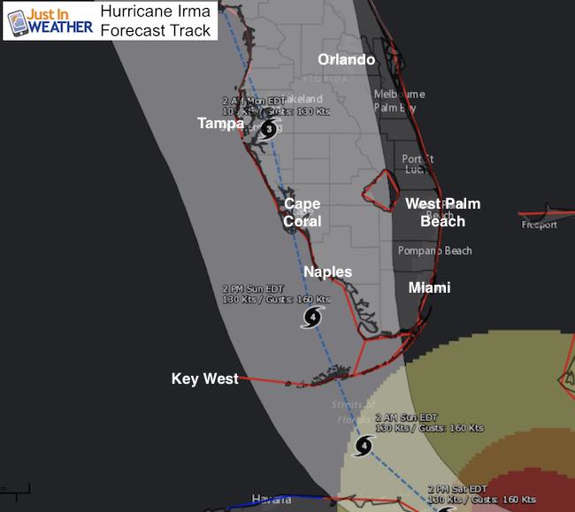
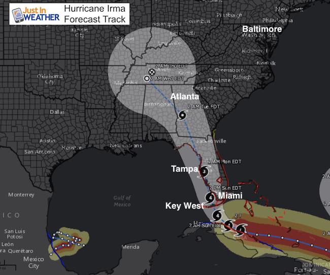
Track
The NHC track shows the center west of Naples but that is not a guarantee. The cone of potential has gotten smaller, as this zeros in on the western half for the eye wall. Note: top winds are around the immediate eye wall and stop to 75 mph at a distance 70 miles away.
Warnings
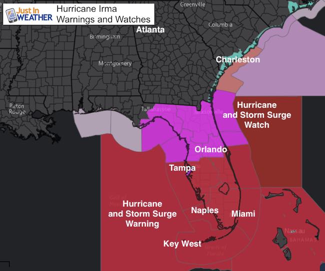
A Hurricane Warning is in effect for…
* Flagler/Volusia County Line southward around the Florida peninsula
to Chassahowitzka
* Florida Keys
* Lake Okeechobee
* Florida Bay
* Cuban provinces of Camaguey, Ciego de Avila, Sancti Spiritus,
Villa Clara, and Matanzas
* Central Bahamas and Ragged Island
* Northwestern Bahamas
A Hurricane Watch is in effect for…
* North of the Flagler/Volusia County Line to Fernandina Beach
* North and west of Chassahowitzka to Indian Pass
* Cuban provinces of Holguin and Las Tunas
A Tropical Storm Warning is in effect for…
* Cuban provinces of Holguin, Las Tunas, La Habana, and Ciudad de
la Habana
A Tropical Storm Watch is in effect for…
* North of Fernandina Beach to Altamaha Sound
Farther Inland
The expectation for the core of Irma to ride north and curve west of Atlanta. This is better news for coastal Georgia and South Carolina, but inland areas will get flooding and tornado risk around the core and on the east side. The storm should dissipate in Tennessee then the rain gets caught into the jet stream and could reach the Mid Atlantic states by the end of next week.
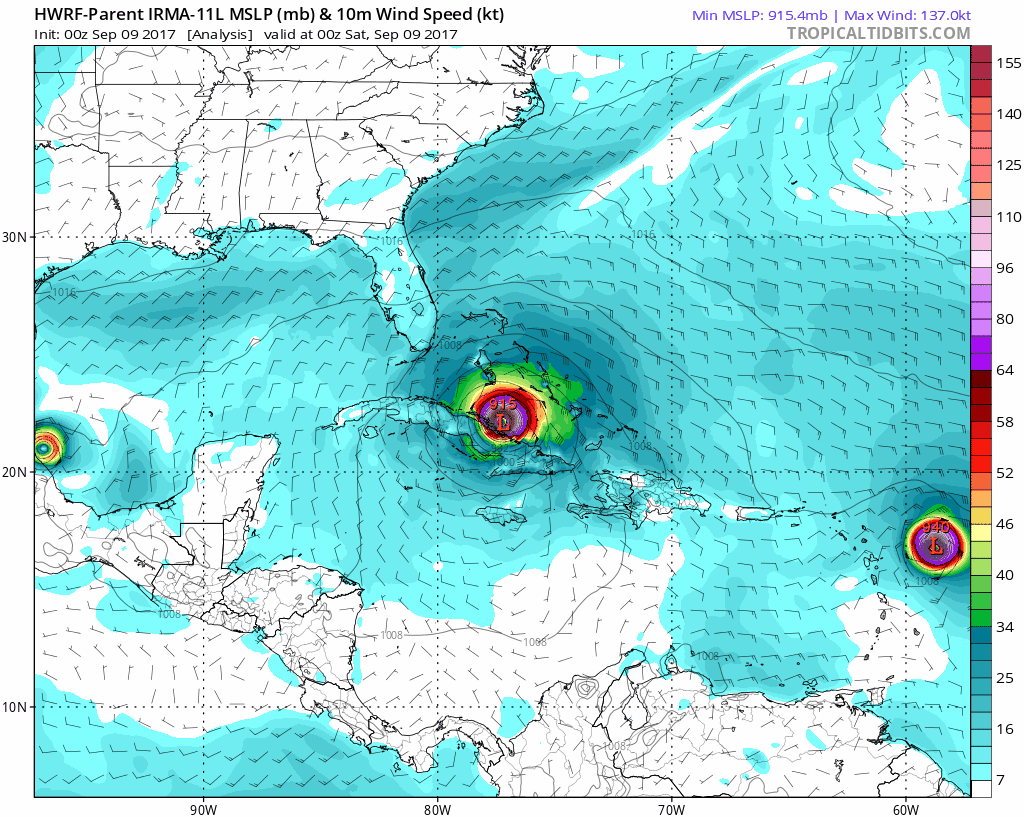
Computer Model Tracks
Keep on Trekking
Continue to be part of our Maryland Trek and Support Cool Kids Campaign. This was our best event yet and we want the message to carry throughout the year.
Proceeds go to programs that help children and their families ensuring cancer treatment.

Please share your thoughts, best weather pics/video, or just keep in touch via social media
-
Facebook: Justin Berk, Meteorologist
-
Twitter: @JustinWeather
-
Instagram: justinweather
 Get the award winning Kid Weather App I made with my oldest son and support our love for science, weather, and technology. Our 3 year anniversary of the release and our contribution to STEM education is this November. It has been downloaded in 60 countries, and works in both temperature scales. With your support we can expand on the fun introduction to science and real weather.