 June 20
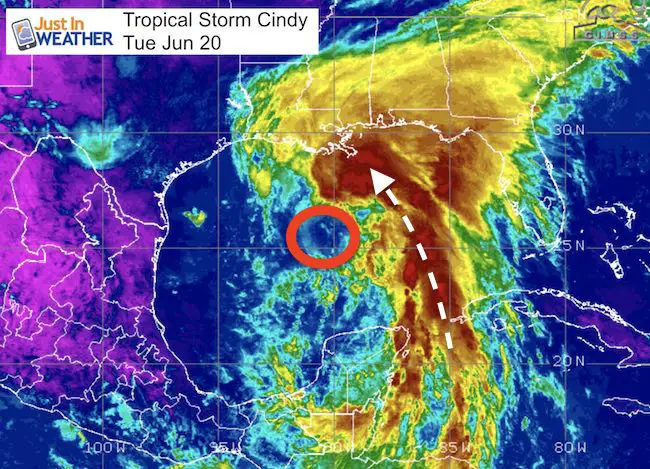
Tropical Storm Cindy was officially named by The National Hurricane Center at 1 PM today. Winds Arte 45 mph and it is nearly stationary, but expected to head north. This is the third named storm of the season but the first impact on the US. The satellite image here shows the large plume of tropical moisture the will be dragged into the Gulf Coast on the east side of the Low. That is the important part of this storm: The wind intensity has limited time to gear up as landfall is expected Wednesday night. Once onshore, the storm will naturally weaken. But the heavy rainfall will cover a large area of the Southeast US (on the east side of the storm) and could reach us in the Mid Atlantic.
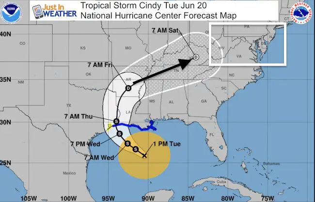
Stats as of 1 PM CDT
LOCATION…25.9N 90.5W
ABOUT 265 MI S OF MORGAN CITY LOUISIANA
ABOUT 355 MI SE OF GALVESTON TEXAS
MAXIMUM SUSTAINED WINDS…45 MPH
PRESENT MOVEMENT…STATIONARY
MINIMUM CENTRAL PRESSURE…999 MB…29.50 INCHES
Forecast Track

The forecast track shows a landfall near the Louisiana and Texas border. Then the storm wil curve to the north and trend east… But as it approaches our region, it will be downgraded to a Depression and may lose much of it’s characteristics. Check out this slider showing the wind flow at 850mb (5,000 Ft).
—> slider
[metaslider id=49085]
Notes:
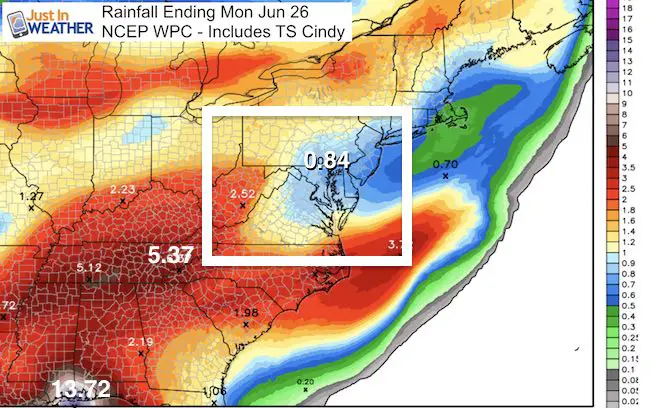
Tropical systems are fickle. The central Low Pressure has so much of the focus that a slight deviation of timing and track and dramatically chance the results 3 to day days later. So I do not put too much stock in long range forecast However, it looks like the bulk of the rain will stay west of the mountains. But we should be alert to potential tropical influence Friday and Saturday as we may heat back to the 90s and fuel more energy with even the expected thunderstorms.
If We Get Anything
The bulk of the rain will dump out across the lower Mississippi and Ohio Tier Valleys, and west of the mountains with respect to us. But if we get anything, it would be Friday into Saturday…

Also See:
2017 Tropical Outlook and Atlantic Names
History of naming tropical storms and hurricanes
 Get the award winning Kid Weather App I made with my oldest son and support our love for science, weather, and technology. Our 3 year anniversary of the release and our contribution to STEM education is this November. It has been downloaded in 60 countries, and works in both temperature scales. With your support we can expand on the fun introduction to science and real weather.
Get $1000 Off LASIK
Plus enter to win free sunglasses
Maryland Trek 2017
Be part of my 4th annual hike and bike across Maryland this August. See my trek page and sign up for information to do one day, the whole week, or even sponsor this great event.
Milestones this year:
- I will do my 1000th mile
- We aim to reach $100,000 for Cool Kids Campaign
Please share your thoughts, best weather pics/video, or just keep in touch via social media
-
Facebook: Justin Berk, Meteorologist
-
Twitter: @JustinWeather
-
Instagram: justinweather
Faith in the Flakes
The store is closing for the season. Next week we wil be shifting back to spring mode. This will include a severe weather STEM assembly program.
-
Sign up for email updates on new posts
Since you may miss some posts via social media, click here for email alerts as a way to make sure you don’t miss any. *You may have to refresh that page once for your browser to clear out the images.
Also See:


