 June 14
Today is Flag Day and there will be some push from the wind as cooler air begins to move in. A cold front will arrive from the north and tip off some showers, but it will not be widespread for us. Look for some showers to develop between noon and 2 PM then the focus will shift west and south of Baltimore. There will be a better chance near and south of Washington later this afternoon. A drop back from our record of 97ºF yesterday to the upper 80s.
Will you see rain?
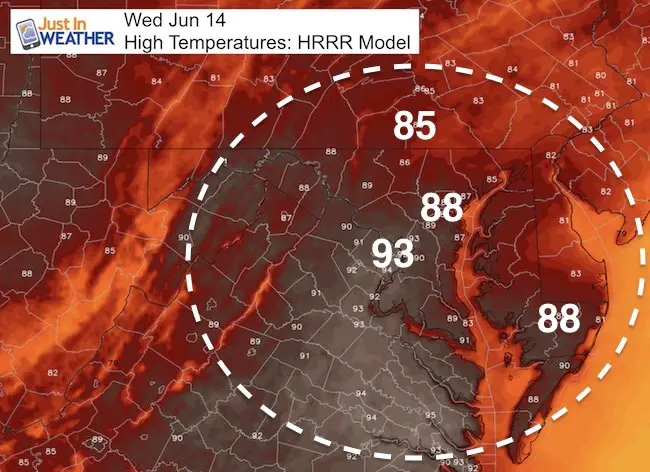
Compare the short range models of the simulated radar for timing and tracking. The similarity is the location of the flare up south of Baltimore later this afternoon.
—-> sliders
HRRR Model
[metaslider id=48709]
NAM Model
[metaslider id=48729]
Outlook
Here are 12 hour snapshots showing the scattered style of storms in the mix through Father’s Day Weekend. The final showdown should be with the cold front and severe storm outbreak next Monday
[metaslider id=48744]
 Get the award winning Kid Weather App I made with my oldest son and support our love for science, weather, and technology. Our 3 year anniversary of the release and our contribution to STEM education is this November. It has been downloaded in 60 countries, and works in both temperature scales. With your support we can expand on the fun introduction to science and real weather.
Get $1000 Off LASIK
Plus enter to win free sunglasses

Maryland Trek 2017
Be part of my 4th annual hike and bike across Maryland this August. See my trek page and sign up for information to do one day, the whole week, or even sponsor this great event.
Milestones this year:
- I will do my 1000th mile
- We aim to reach $100,000 for Cool Kids Campaign

Please share your thoughts, best weather pics/video, or just keep in touch via social media
-
Facebook: Justin Berk, Meteorologist
-
Twitter: @JustinWeather
-
Instagram: justinweather
Faith in the Flakes
The store is closing for the season. Next week we wil be shifting back to spring mode. This will include a severe weather STEM assembly program.
-
Sign up for email updates on new posts
Since you may miss some posts via social media, click here for email alerts as a way to make sure you don’t miss any. *You may have to refresh that page once for your browser to clear out the images.
Also See: