 Wednesday March 29 – Yesterday engaged us with thunderstorms that only amounted to 0.30 inches of rain for Baltimore. That is just a small dent into the moderate drought, but more needed rain is on the way. First, we have a quiet pattern with sunshine returning today. This afternoon will be mild in the 60s, and cooler air filters in with the 50s tomorrow. All the action will be across the nation’s heartland with another outbreak of severe, damaging storms. That storm will head our way in a weakened form Friday, but give us needed rain. Then… A quiet weekend.
Here’s a look at the set up for our wet Friday. Please note that ‘stormy’ can mean thunderstorms with heavy rain, but not always turning severe. The Severe Outlook maps are below
—> slider Friday Rain
[metaslider id=46030]
Rainfall Potential
Compare to our Moderate Drought report

Severe Storm Outlook


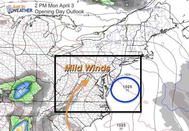
Opening Day Outlook
High Pressure should be in control and slipping off of the coast. That brings in mild winds from the southwest. Expect high temps in the lower 60s
Temperature Outlook

 Get the award winning Kid Weather App I made with my oldest son and support our love for science, weather, and technology. Our 3 year anniversary of the release and our contribution to STEM education is this November. It has been downloaded in 60 countries, and works in both temperature scales. With your support we can expand on the fun introduction to science and real weather.
Please share your thoughts, best weather pics/video, or just keep in touch via social media
-
Facebook: Justin Berk, Meteorologist
-
Twitter: @JustinWeather
-
Instagram: justinweather
Faith in the Flakes
The store is closing for the season. Next week we wil be shifting back to spring mode. This will include a severe weather STEM assembly program.
-
Sign up for email updates on new posts
Since you may miss some posts via social media, click here for email alerts as a way to make sure you don’t miss any. *You may have to refresh that page once for your browser to clear out the images.
Also See:
My Winter Outlook for 2016-2017: Colder with snow spread out more
NOAA Winter Outlook for 2016 to 2017
La Nina Formed: What it could mean to our winter
Farmers Almanacs Split On Cold And Snow
Extreme Weather of 2015 balanced out on both ends
Low Snow Winters In Baltimore: Records Might Surprise You