The storm that hit our region Monday night and Tuesday is easily the largest impact event of the poor winter showing this season. The snow amounts did have a wide range with some getting exactly what they expected and others left underwhelmed or disappointed. The heavy snow did fall in the predicted range along northern Maryland and southern PA. The big winner was in the TV market I worked in 20 years ago. That map is at the bottom of this post. Below are the snow reports, my account for what went right and what went wrong, and a change for you to grade my forecast, But it is hard to argue that snow and ice left some amazing things behind.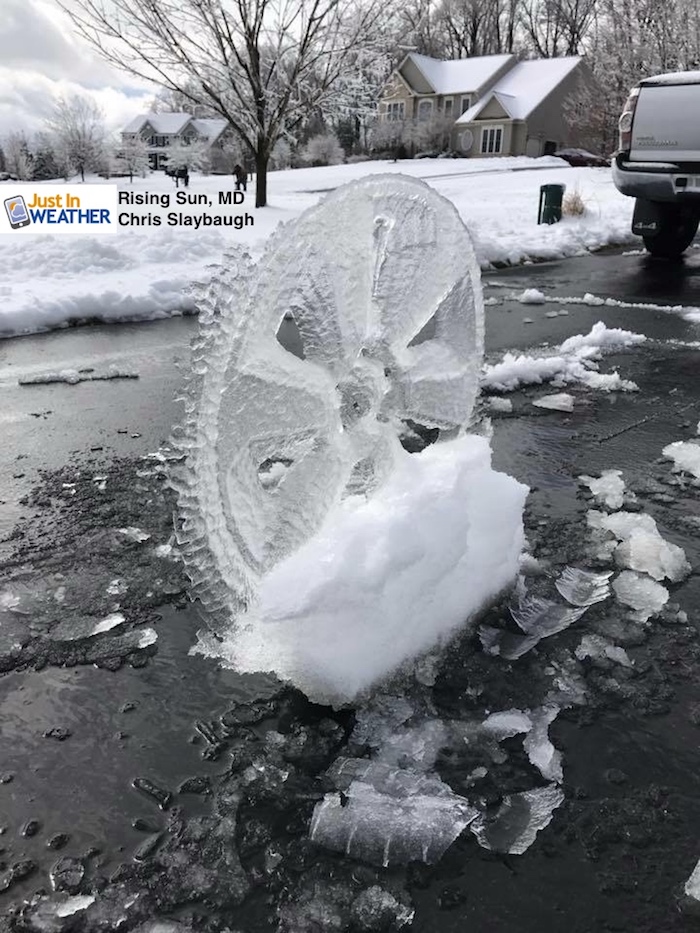
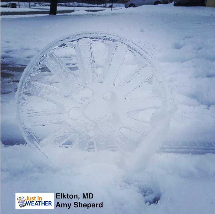
Rising Sun in Cecil County had plenty of ice on top of their snow. Chris Slaybaugh pulled his truck away and found a mold of his nice rims left behind. He wasn’t the only one. Amy Shepard had this as well in nearby Elkton. It was moderate snow and heavy ice that hit northeastern Maryland the hardest. This is where numerous trees were downed along with the most power outages. But the ice display here is amazing.
March 14 snow totals below will show that and open the door to debate how to classify the event. I challenge you to please read and my notes and the reports and still call this a bust. I am first to admit when my storm forecast is wrong and will grade myself harshly. But even if you got less snow than my final call (or someone elses), it was an event that had more correct than wrong.
Grade My Forecast
I know many want to give this an F. I worked in retail and as a waiter during high school and college. I was taught the customer is always right, or do what you can to make them happy. If ‘you’ the customer of my weather service perceive something wrong, there is not much I can do to change that. But I ask that you consider the entire forecast beyond just the snow total.
I have this map posted again in the slider to line up with my maps. The snow spotter report list is at the bottom of this post. 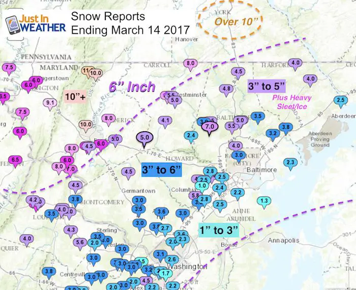
In short, I didn’t listen to myself. I have been saying all season and with this storm that models have been wrong. The storms have been verifying warmer and farther north. I saw the BWI high on Monday colder than forecast. I also saw a cold air dam setting up in the evening that should lock in the cold. So I went with the colder HRRR Model and stayed the course. We did get the cold to hold, but the warmer Chesapeake Bay mixed in warmer air at mid levels angled to the extensive sleet and icing.
My clients were are contracted to remove snow all said that the sleet made for a very heavy product. This storm was not easy to clear and what wasn’t handled Tuesday night was a solid block of ice this morning. The sleet did compact the snow so the what fell was a little more than what was measured…. and weighed twice as much compared to a light snow at 20ºF.
What Went Right?
- The timing of the arrive Monday evening
- Heavy snow overnight
- Mix over near and south of I-95 in the morning
- Widespread travel problems and the school closings were justified.
- The 10 inch snow range did hit Frederick up through York PA
- Ended with snow by Tuesday afternoon
- High winds gusting over 40 mph
- Refreeze and ice returning Tuesday night and light snow Wednesday.
What went wrong?
- Plenty more sleet than expected.
- The snow totals in metro Baltimore were low.
- My final call in central Maryland north of Baltimore was 6 to 12 inches, but many just see the high number (12) . Baltimore City got 3 to 4 inches and the county average was 3 to 6 inches. There was one 7 inch report in Reisterstown
- Heavy icing. This showed up on the maps, but wasn’t discussed enough in my reports
- Annapolis got little to no snow
My Grade?
Overall I will give my forecast a C+. It would be an A for Frederick to York PA. But a D for Annapolis. Please see the reports and maps below and then share your grade for my forecast in the social media post where you found this article. FITF
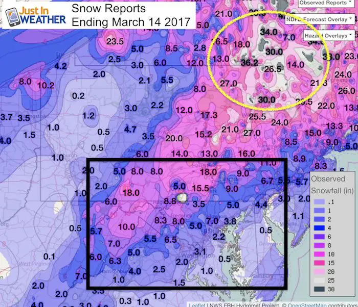
Snow Reports
Regional maps and my Final Call For Snowfall to compare are below:
Baltimore:
2.5 Inches = Storm Total at BWI
3.2 Inches = Season Total at BWI
Baltimore City range was 3 to over 4 inches
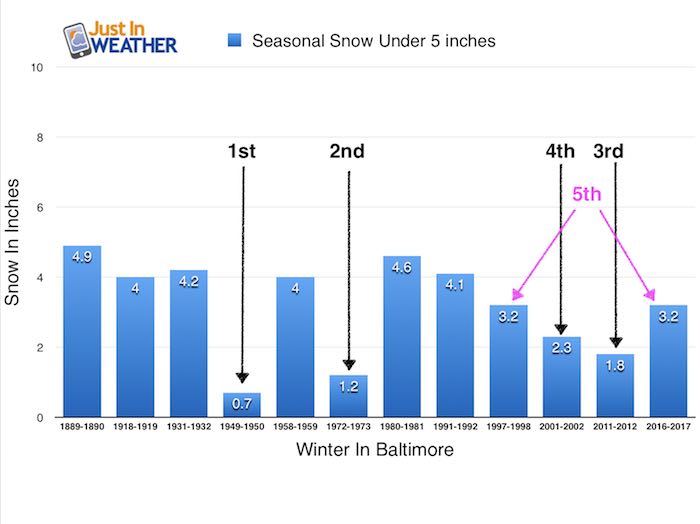
*This storm helped break the tie for the lowest snow season on record. 1059 has that solo spot again. This year is now tied for 5th lowest winter seasonal snowfall with 1997-1998
Regional Snow Reports
Compare the maps in the slider to my final call for snowfall below
Central Maryland: Snow amounts were lower than expected due to the heavy sleet. This not only cut off the snow accumulation but also weighed down the and compacted the snow pack.
Northern Maryland and southern Pennsylvania: This region was very close or safely in the expected snow zone (as usual). This is where sleet had little to no impact.
Western Howard, Montgomery
On the edge of heavy sleet mixing in, but an average of 5 inches or more. Columbia/Ellicott City ranged between 1 and 5 inches of snow.
Frederick and Carroll County were on the edge and varied greatly depending on the sleet or no change over. Frederick was the winner and fit in my Final Call For Snowfall Map with many places over 10 inches. Carroll County ranged from 3 to 8 inches.
Annapolis and south
This area had a faster change over, but still plenty of ice.
Metro Washington
2 to 3 inches in the city but a lot more just inland
—> slider Snow Report Maps
[metaslider id=45532]
My Final Call and Adjusted Call Lowered
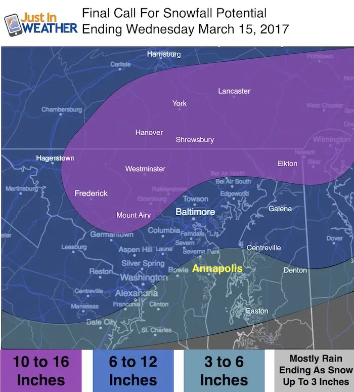
With the wider region of sleet, I adjusted the snow totals lower early Tuesday morning.

Rare Storm For March?
See my report on March Snowstorm History In Baltimore
#FITF Gear
We are doing a special run of more Faith in the Flakes shirts this week. Click here for the online store to get yours.
And The Winner Is….
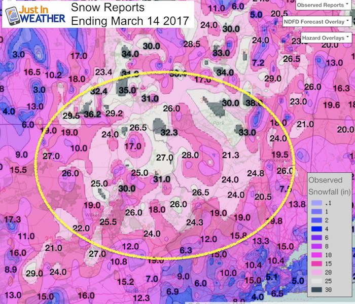
36.2 inches
Endwell, NY was where this all ended well. Just west of Binghamton. Shout out to my former station WBNG (1995-1997).
30 inches in Scranton, PA
Reports From the NWS Office For the Central Maryland Region
********************STORM TOTAL SNOWFALL********************

LOCATION          STORM TOTAL     TIME/DATE   COMMENTS
                     SNOWFALL           OF
                     /INCHES/   MEASUREMENT

DISTRICT OF COLUMBIA

...DISTRICT OF COLUMBIA...
   1 WSW NATIONAL ZOO     3.1   940 AM  3/14  TRAINED SPOTTER
   1 E WASHINGTON         2.6   830 AM  3/14  TRAINED SPOTTER

MARYLAND

...ALLEGANY COUNTY...
   1 NNE CUMBERLAND      10.0   844 AM  3/14  TRAINED SPOTTER
   ECKHART MINES          9.5   558 PM  3/14  TRAINED SPOTTER
   SSW CRESAPTOWN         9.2   900 AM  3/14  TRAINED SPOTTER
   MOUNT SAVAGE           9.0   915 AM  3/14  TRAINED SPOTTER
   FROSTBURG              8.0   900 AM  3/14  TRAINED SPOTTER
   2 ESE RIDGELEY         8.0   850 AM  3/14  TRAINED SPOTTER
   FROSTBURG              8.0   830 AM  3/14  TRAINED SPOTTER
   SE FROSTBURG           8.0   900 AM  3/14  TRAINED SPOTTER

...ANNE ARUNDEL COUNTY...
   1 ESE GEORGETOWN       2.5  1030 AM  3/14  TRAINED SPOTTER
   BWI AIRPORT            2.2   228 PM  3/14  AIRPORT
   1 S RIVIERA BEACH      1.3   128 PM  3/14  TRAINED SPOTTER

...BALTIMORE COUNTY...
   1 ESE REISTERSTOWN     7.0   434 PM  3/14  TRAINED SPOTTER
   1 WSW GLYNDON          5.9   231 PM  3/14  TRAINED SPOTTER
   2 NNW BROOKLANDVILLE   5.5   325 PM  3/14  TRAINED SPOTTER
   COCKEYSVILLE           5.0   911 AM  3/14  BROADCAST MEDIA
   COCKEYSVILLE           5.0   300 PM  3/14  TRAINED SPOTTER
   3 WNW HEREFORD         4.8   304 PM  3/14  TRAINED SPOTTER
   1 W ILCHESTER          4.8  1000 AM  3/14  TRAINED SPOTTER
   1 E BENTLEY SPRINGS    4.5   840 AM  3/14  TRAINED SPOTTER
   1 E GLYNDON            4.5   236 PM  3/14  TRAINED SPOTTER
   1 NNE UPPER FALLS      3.8   200 PM  3/14  TRAINED SPOTTER
   2 NW LONG GREEN        3.5  1032 AM  3/14  TRAINED SPOTTER
   1 NNE PERRY HALL       3.2  1000 AM  3/14  TRAINED SPOTTER
   1 SW GLYNDON           3.0   251 PM  3/14  TRAINED SPOTTER
   1 SSE CATONSVILLE      2.5   815 AM  3/14  TRAINED SPOTTER
   MIDDLE RIVER           2.3  1029 AM  3/14  PUBLIC

...BALTIMORE CITY...
   1 NE PIMLICO           4.0  1215 PM  3/14  COCORAHS
   2 E ARLINGTON          3.0   846 AM  3/14  BROADCAST MEDIA

...CARROLL COUNTY...
   1 W WESTMINSTER        8.0   900 AM  3/14  COCORAHS
   3 WSW LINEBORO         8.0  1131 AM  3/14  TRAINED SPOTTER
   SE WESTMINSTER         5.5   130 PM  3/14  TRAINED SPOTTER
   2 SE WESTMINSTER       5.0   930 AM  3/14  TRAINED SPOTTER
   2 NNE WINFIELD         4.1   441 PM  3/14  TRAINED SPOTTER
   NE OAKLAND             2.4  1015 AM  3/14  TRAINED SPOTTER

...CHARLES COUNTY...
   1 NW WICOMICO          0.2   800 AM  3/14  TRAINED SPOTTER
   2 NE BRYANTOWN         0.1   852 AM  3/14  TRAINED SPOTTER

...FREDERICK COUNTY...
   2 SSE SABILLASVILLE   11.0   200 PM  3/14  TRAINED SPOTTER
   3 N THURMONT          10.0  1109 AM  3/14  TRAINED SPOTTER
   3 NW FREDERICK        10.0   800 AM  3/14  NWS EMPLOYEE
   JEFFERSON              8.0  1130 AM  3/14  NWS EMPLOYEE
   1 E WALKERSVILLE       8.0   800 AM  3/14  TRAINED SPOTTER
   POINT OF ROCKS         7.0  1042 AM  3/14  TRAINED SPOTTER
   1 W BALLENGER CREEK    6.8   900 AM  3/14  TRAINED SPOTTER
   3 NNW POINT OF ROCKS   6.0   300 PM  3/14  TRAINED SPOTTER
   3 E BALLENGER CREEK    6.0   900 AM  3/14  COUNTY EMRG MGMT
   2 NW NEW MARKET        5.0   900 AM  3/14  TRAINED SPOTTER
   SW BALLENGER CREEK     4.5   830 AM  3/14  TRAINED SPOTTER

...HARFORD COUNTY...
   2 E SCARBORO           4.0   229 PM  3/14  TRAINED SPOTTER
   WHITEFORD              4.0  1045 AM  3/14  TRAINED SPOTTER
   1 NNW HAVRE DE GRACE   2.5  1203 PM  3/14  TRAINED SPOTTER

...HOWARD COUNTY...
   1 SSE SIMPSONVILLE     5.8   330 PM  3/14  TRAINED SPOTTER
   2 N COLUMBIA           4.5  1115 AM  3/14  TRAINED SPOTTER
   2 W SAVAGE             3.8   445 PM  3/14  TRAINED SPOTTER
   1 N SAVAGE             2.8   800 AM  3/14  TRAINED SPOTTER
   1 SW OELLA             2.8   200 PM  3/14  TRAINED SPOTTER
   2 NE COLUMBIA          2.5  1155 AM  3/14  TRAINED SPOTTER
   ELKRIDGE               2.4   838 AM  3/14  NWS EMPLOYEE
   1 ENE COLUMBIA         1.0  1200 PM  3/14  TRAINED SPOTTER

...MONTGOMERY COUNTY...
   3 SSW DAMASCUS         4.5  1120 AM  3/14  CO-OP OBSERVER
   1 ENE GARRETT PARK     3.8   815 AM  3/14  TRAINED SPOTTER
   4 NE LEESBURG          3.8   800 AM  3/14  TRAINED SPOTTER
   1 ESE NORBECK          3.6  1015 AM  3/14  TRAINED SPOTTER
   1 WSW DERWOOD          3.5   947 AM  3/14  OTHER FEDERAL
   1 NNE FAIRLAND         3.0   244 PM  3/14  TRAINED SPOTTER
   1 NNE WASHINGTON GRO   3.0   845 AM  3/14  TRAINED SPOTTER
   2 SSW ROCKVILLE        3.0  1100 AM  3/14  TRAINED SPOTTER
   1 ESE WHEATON          2.7  1145 AM  3/14  TRAINED SPOTTER
   1 ESE TAKOMA PARK      2.0   820 AM  3/14  TRAINED SPOTTER

...PRINCE GEORGES COUNTY...
   1 ENE ADELPHI          2.6  1130 AM  3/14  TRAINED SPOTTER
   1 SW COLLEGE PARK      2.3   900 AM  3/14  TRAINED SPOTTER
   1 S FOREST HEIGHTS     2.2  1155 AM  3/14  TRAINED SPOTTER

...WASHINGTON COUNTY...
   3 NNW PECKTONVILLE     9.5  1045 AM  3/14  NWS EMPLOYEE
   3 NNE BOONSBORO        9.1  1130 AM  3/14  TRAINED SPOTTER
   3 SW FAIRPLAY          7.5   150 PM  3/14  TRAINED SPOTTER
   3 NNW CONOCOCHEAGUE    7.5  1105 AM  3/14  TRAINED SPOTTER
   HAGERSTOWN             6.0   150 PM  3/14  TRAINED SPOTTER
   1 NE HALFWAY           6.0   915 AM  3/14  TRAINED
 Get the award winning Kid Weather App I made with my oldest son and support our love for science, weather, and technology. Our 3 year anniversary of the release and our contribution to STEM education is this November. It has been downloaded in 60 countries, and works in both temperature scales. With your support we can expand on the fun introduction to science and real weather.
Please share your thoughts, best weather pics/video, or just keep in touch via social media
-
Facebook: Justin Berk, Meteorologist
-
Twitter: @JustinWeather
-
Instagram: justinweather
Faith in the Flakes Online- Flannel PJs Printed Inside Out
Store Now Open

- We’ve added Flannel PJ Pants that will be printed inside out. They have to be, to make it snow ?
- Free Personal Delivery for orders of 20 items or more to schools and businesses.
- Click this image for the online store.
- Look for more items to be added soon.
- Also see the info for the STEM Assembly Spirit Wear program: Put your school name on the shirts and raise money for you PTO/PTA in the process.
Sign up for email updates on new posts
Since you may miss some posts via social media, click here for email alerts as a way to make sure you don’t miss any. *You may have to refresh that page once for your browser to clear out the images.
FITF SNOW STICKS
 Available in 2 Ft, 30 Inches, and 3 Ft Sizes. Also with Orange/Black or Purple/Black. Click on the image to see the options offered by my friend Thatcher at Signs By Tomorrow in Timonium.
Go to http://www.signsbytomorrow.com/timonium/ to order yours today! Click the ‘Request a Quote’ button at the top of the page. In comment box include color, size and payment information. Please indicate whether you’d like to have us UPS ship them to you or if you would like to pick up in our store. Snow Sticks will ship or will be ready for pick up in our store 48 hrs after order is placed, Mon-Fri.
Also See:
My Winter Outlook for 2016-2017: Colder with snow spread out more
NOAA Winter Outlook for 2016 to 2017
La Nina Formed: What it could mean to our winter
Farmers Almanacs Split On Cold And Snow
Extreme Weather of 2015 balanced out on both ends
Low Snow Winters In Baltimore: Records Might Surprise You