Tuesday March 7 – As I was gathering information and making my forecast this morning, one thought jumped into my mind. When my boys wake up the often ask me if they wil have recess outside. But considering the mention of snow already, I know many want to just know about the impact for races and other plans with the potential for a storm this weekend. So much to say, and dare I quote Dave Matthews… “Don’t talk about it. Talk about the weather”. That’s the plan…
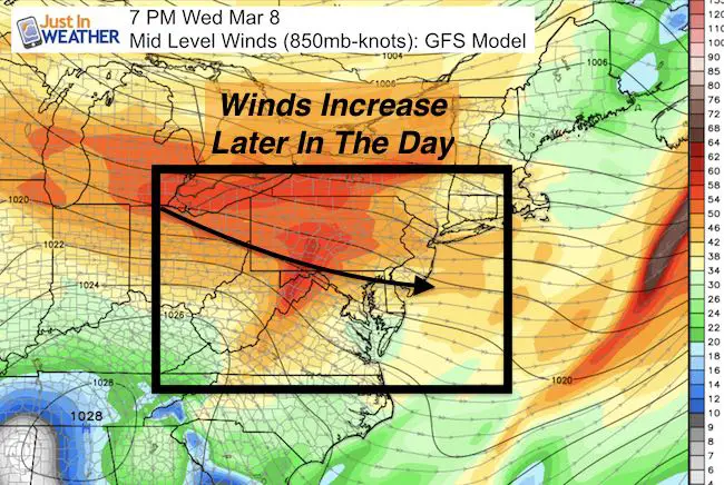
Today wil be part of a three day stretch back into the 60s. There is rain this morning, and the next band this by evening. A moderate cold front will arrive after midnight, then we get another surge of strong winds increasing Wednesday afternoon and night. This is when the cold air is set to move in. We have a little system that wil bring us snow Friday, but the freezing line may stay near the PA line in the morning and shift north. So stickage will be limited. The storm on Sunday… That needs a little more explanation below. Here are the maps:
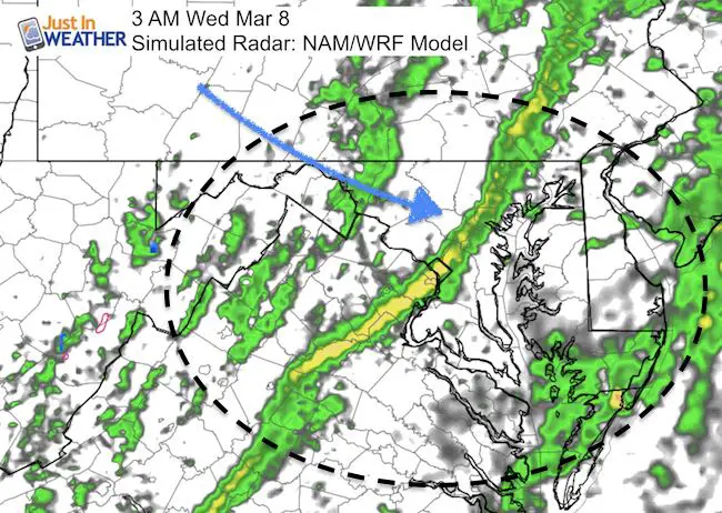
Rain Today: Simulated Radar —> slider HRRR Model
Cold Front After Midnight
Winds Increase Wednesday Afternoon and Evening
Light Snow Friday? Watch the freezing line
—> slider GFS Model
I expect snow in the morning, but the ground is warm and the freezing line appears to briefly slip into northern Maryland. At this point, I would expect metro Baltimore roads to stay wet.
[metaslider id=43939]Weekend Storm?
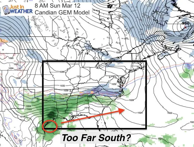
This needs a little explanation. The European Model, which has the best long range track record and first to see this event… has shifted south. The GFS Model here is more consistent, but bumped a little south as well. If we consider the trend all winter for events to verify farther north… then we can expect the bump back in projections over the next few days.
*I think the model is overdoing the cold air. We had a southern snow track on January 7-8 the brought a foot of snow to the beaches. That was January. This is March and we are missing snowpack to the north AND little to no blocking for now. Also, the energy for this storm is still over the Pacific. Models tend to have an ambiguous period when shifting from long to short range and waiting for the energy to enter the grid. So the next two days may appear to fluctuate a lot before locking back on the storm.
—> slider GFS Model
[metaslider id=43946]
Canadian Model: Very Different.
I have often pointed this to computer model with confidence in the winter. But that is in a cold pattern. This year has not been and shown the error in these solutions. I still want to contrast how it depicts the next events…. Very differently.
Weekend Storm- Much farther south with the northern edge of snow in North Carolina and the surface Low near the Gulf coast.
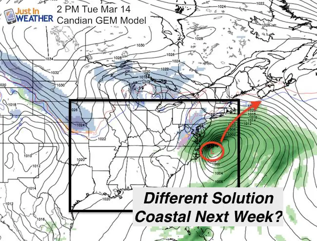
Coastal Storm Next Week?
This seems to be saving the energy for another system off of the coast Tuesday… but a lack of cold air. It shows snow but temps in the upper 30s in central Maryland. That would mean (if it were true) a wet snow form colder clouds, but melting on warmer ground.
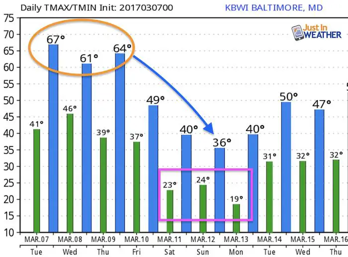
Temperature Outlook
At least this model output has caught on to the cold air for the weekend. I would focus more on the morning lows than the afternoon highs this weekend.
 Get the award winning Kid Weather App I made with my oldest son and support our love for science, weather, and technology. Our 3 year anniversary of the release and our contribution to STEM education is this November. It has been downloaded in 60 countries, and works in both temperature scales. With your support we can expand on the fun introduction to science and real weather.
Please share your thoughts, best weather pics/video, or just keep in touch via social media
-
Facebook: Justin Berk, Meteorologist
-
Twitter: @JustinWeather
-
Instagram: justinweather
Faith in the Flakes Online- Flannel PJs Printed Inside Out
Store Now Open

- We’ve added Flannel PJ Pants that will be printed inside out. They have to be, to make it snow ?
- Free Personal Delivery for orders of 20 items or more to schools and businesses.
- Click this image for the online store.
- Look for more items to be added soon.
- Also see the info for the STEM Assembly Spirit Wear program: Put your school name on the shirts and raise money for you PTO/PTA in the process.
Sign up for email updates on new posts
Since you may miss some posts via social media, click here for email alerts as a way to make sure you don’t miss any. *You may have to refresh that page once for your browser to clear out the images.
FITF SNOW STICKS
 Available in 2 Ft, 30 Inches, and 3 Ft Sizes. Also with Orange/Black or Purple/Black. Click on the image to see the options offered by my friend Thatcher at Signs By Tomorrow in Timonium.
Go to http://www.signsbytomorrow.com/timonium/ to order yours today! Click the ‘Request a Quote’ button at the top of the page. In comment box include color, size and payment information. Please indicate whether you’d like to have us UPS ship them to you or if you would like to pick up in our store. Snow Sticks will ship or will be ready for pick up in our store 48 hrs after order is placed, Mon-Fri.
Also See:
My Winter Outlook for 2016-2017: Colder with snow spread out more
NOAA Winter Outlook for 2016 to 2017
La Nina Formed: What it could mean to our winter
Farmers Almanacs Split On Cold And Snow
Extreme Weather of 2015 balanced out on both ends
Low Snow Winters In Baltimore: Records Might Surprise You
Faith in the Flowers
In a few weeks my friend Lexi Hack and I will be bringing back these shirts and the fundraiser for Save a Limb Fund at Sinai Hospital. Also stay tuned for my new Storm Smart Assembly program. A STEM based assembly on severe weather for elementary and middle schools.