Monday March 6 – We just came off of the coldest period we have seen in a month dropping into the teens Sunday morning. We have also gone an entire calendar year without 1 inch of snow, from March 3-4 2016 when 2.5″ fell on BWI. That was not a record, but felt like it. In this winter without much winter, it may be hard to believe that there is potential for a snow storm in March, but then again it might just fit the unusual pattern. Before I get started and get to the maps below, I have a few things I want to share. Today we have a warm front that is producing some flurries. Then we have a warm storm that will bring rain Tuesday into Wednesday morning, along with temps in the 60s. Then it gets colder with a few chances of snow. I have been reluctant to bite in this information and share until there was more support. We have that now.
There has been a poor track record this winter with models projecting a storm about a week away, then losing it. Either the storms have verified farther north, meaning a warmer set up and rain for us… Or the ingredients have not come together. The difference now is that there seems to be more support now that we are under a week timeframe. So this will be something we chat about all week. Maps are below, but here is some trivia…
Snow in March?
Snow in March is more common than you might imagine. While Baltimore averages 1.9 inches of snow this month, some big storms are recored as well. In fact, it often comes with one extreme or another. The month of March has produced quite a few large storms. If fact one of the top storms was at the very end of the month. Here is a list of some of the events you might remember or hear others talk about:
#FITF
Top 6 Baltimore Snowstorms in March
- 22.0″ March 28-29 in 1942
- 12.0″ March 18 in 1892
- 11.3″ March 13 1993
- 10.5″ March 2-4 in 1960
- 10.0″ March 6 in 1962
- 10.0″ March 7 in 1941
Recent Baltimore Snowstorms in March
- 4.7″ March 2 in 2009
- 6.2″ March 5 in 2015
- 3.2″ March 25 in 2013 *Only 8 inches total that entire winter
Rain First GFS Model —> slider
Here is the first storm that will warm us up and bring Rain Tuesday and Wednesday
Chance of Snow Part 1: Friday
This is important to watch… because any adjustment in track could lead us to hints at the larger event to follow.
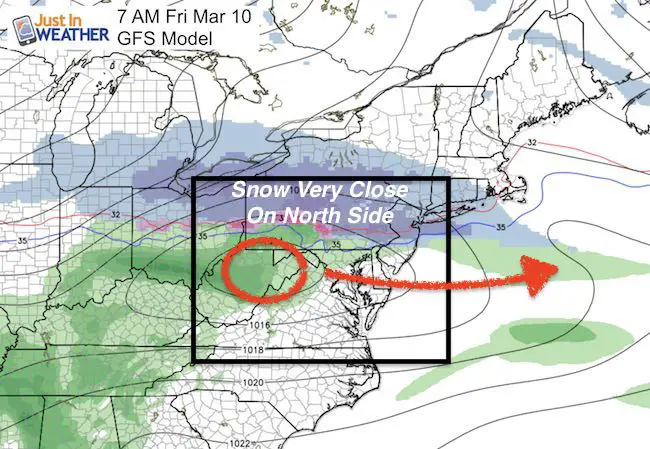
Will There Be A Snowstorm Next Weekend?
The GFS Model just came on to support the European Model that has been showing this for a few days. The Canadian Model is lagging behind with a weaker event, but pushed farther south. That is actually a good thing to support the history of north shifting events… to come in line and possibly support the others.
I will NOT give potential snow amounts until within 72-48 hours ahead of the storm.
GFS Model —> slider
Note: Daylight Saving Time is 2 AM Sunday March 12
[metaslider id=43909]
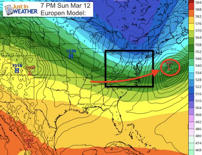
European Model
This shows the surface Low track and the cold jet stream with some blocking to the north infusing colder air. Note that any other maps from this model actually violate their copywrite. I respect that, and if you see it somewhere else is should be from a paid service or with written permission to show on a public forum.
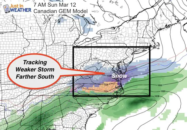
Canadian GEM Model
This shows a weaker storm, father south…. but allows for the error shift to the north to support the others.
Jet Stream: Trending Colder —> slider
[metaslider id=43900]
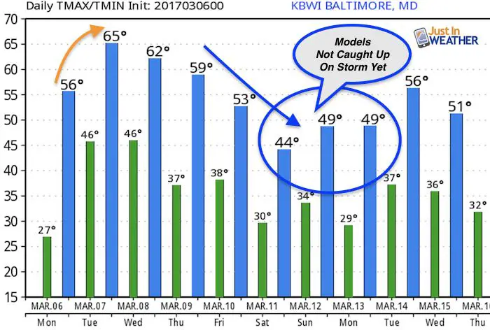
Temperature Outlook
The mild temps next weekend don’t show that that modeling has caught on to the storm idea yet.
 Get the award winning Kid Weather App I made with my oldest son and support our love for science, weather, and technology. Our 3 year anniversary of the release and our contribution to STEM education is this November. It has been downloaded in 60 countries, and works in both temperature scales. With your support we can expand on the fun introduction to science and real weather.
Please share your thoughts, best weather pics/video, or just keep in touch via social media
-
Facebook: Justin Berk, Meteorologist
-
Twitter: @JustinWeather
-
Instagram: justinweather
Faith in the Flakes Online- Flannel PJs Printed Inside Out
Store Now Open
- We’ve added Flannel PJ Pants that will be printed inside out. They have to be, to make it snow ?
- Free Personal Delivery for orders of 20 items or more to schools and businesses.
- Click this image for the online store.
- Look for more items to be added soon.
- Also see the info for the STEM Assembly Spirit Wear program: Put your school name on the shirts and raise money for you PTO/PTA in the process.
Sign up for email updates on new posts
Since you may miss some posts via social media, click here for email alerts as a way to make sure you don’t miss any. *You may have to refresh that page once for your browser to clear out the images.
FITF SNOW STICKS
 Available in 2 Ft, 30 Inches, and 3 Ft Sizes. Also with Orange/Black or Purple/Black. Click on the image to see the options offered by my friend Thatcher at Signs By Tomorrow in Timonium.
Go to http://www.signsbytomorrow.com/timonium/ to order yours today! Click the ‘Request a Quote’ button at the top of the page. In comment box include color, size and payment information. Please indicate whether you’d like to have us UPS ship them to you or if you would like to pick up in our store. Snow Sticks will ship or will be ready for pick up in our store 48 hrs after order is placed, Mon-Fri.
Also See:
My Winter Outlook for 2016-2017: Colder with snow spread out more
NOAA Winter Outlook for 2016 to 2017
La Nina Formed: What it could mean to our winter
Farmers Almanacs Split On Cold And Snow
Extreme Weather of 2015 balanced out on both ends
Low Snow Winters In Baltimore: Records Might Surprise You
Faith in the Flowers
In a few weeks my friend Lexi Hack and I will be bringing back these shirts and the fundraiser for Save a Limb Fund at Sinai Hospital. Also stay tuned for my new Storm Smart Assembly program. A STEM based assembly on severe weather for elementary and middle schools.
