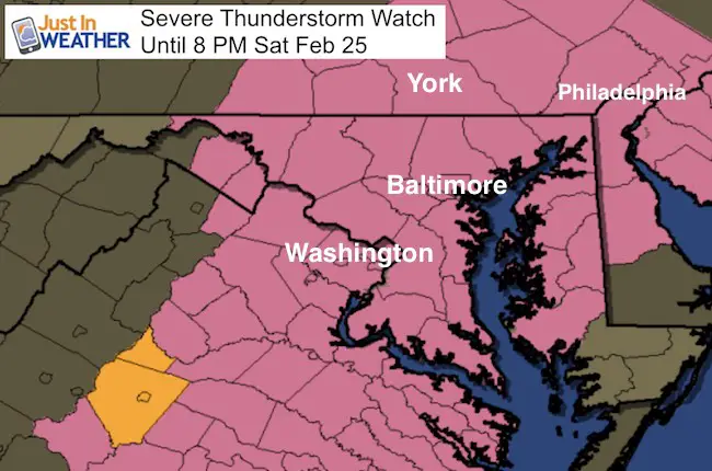
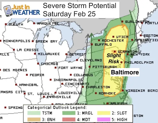
 Saturday February 25 – A Severe Thunderstorm Watch has been issued for this afternoon and evening for central Maryland and south central Pennsylvania. The storms will last roughly an hour or two, and the action will be done before the end time stamp of 8 PM. While the radar was quiet in my prior post at noon, I expected the activity to pick up quickly due to the wind flow and moisture in the air. That has been the case in the past hour. The Watch means conditions are present for storms to turn severe with winds gusting past 58 mph and large hail over 1 inch in diameter. There is a very small risk of an isolated tornado.
I need to highlight that the watch covers a large area, but the not all will see these conditions for the full time period. In fact, the area will be shaved off from west to east as the front passes. The radar simulation below shows most of the storms will be off of the coast by 6 or 7 PM.
Doppler Radar got Michu more active in the past 2 hours

Here is the latest radar simulation.
slider—> HRRR Model
[metaslider id=43684]
Note: Should there nbc any severe storms, sleep these terms in mind
Severe Thunderstorm: Storms with wind gusts over 58 mph an or large hail over 1 inch in diameter.
Watch: Potential for a region. Usually a 6 hour window
Warning: Tracking actual severe storms. This usually last 30 to 45 minutes and issued per county.
Links:
Prior Post (compare radar simulation update)
 Get the award winning Kid Weather App I made with my oldest son and support our love for science, weather, and technology. Our 3 year anniversary of the release and our contribution to STEM education is this November. It has been downloaded in 60 countries, and works in both temperature scales. With your support we can expand on the fun introduction to science and real weather.
Please share your thoughts, best weather pics/video, or just keep in touch via social media
-
Facebook: Justin Berk, Meteorologist
-
Twitter: @JustinWeather
-
Instagram: justinweather
Faith in the Flakes Online- Flannel PJs Printed Inside Out
Store Now Open

- We’ve added Flannel PJ Pants that will be printed inside out. They have to be, to make it snow ?
- Free Personal Delivery for orders of 20 items or more to schools and businesses.
- Click this image for the online store.
- Look for more items to be added soon.
- Also see the info for the STEM Assembly Spirit Wear program: Put your school name on the shirts and raise money for you PTO/PTA in the process.
Sign up for email updates on new posts
Since you may miss some posts via social media, click here for email alerts as a way to make sure you don’t miss any. *You may have to refresh that page once for your browser to clear out the images.
FITF SNOW STICKS
 Available in 2 Ft, 30 Inches, and 3 Ft Sizes. Also with Orange/Black or Purple/Black. Click on the image to see the options offered by my friend Thatcher at Signs By Tomorrow in Timonium.
Go to http://www.signsbytomorrow.com/timonium/ to order yours today! Click the ‘Request a Quote’ button at the top of the page. In comment box include color, size and payment information. Please indicate whether you’d like to have us UPS ship them to you or if you would like to pick up in our store. Snow Sticks will ship or will be ready for pick up in our store 48 hrs after order is placed, Mon-Fri.
Also See:
My Winter Outlook for 2016-2017: Colder with snow spread out more
NOAA Winter Outlook for 2016 to 2017
La Nina Formed: What it could mean to our winter
Farmers Almanacs Split On Cold And Snow
Extreme Weather of 2015 balanced out on both ends
Low Snow Winters In Baltimore: Records Might Surprise You