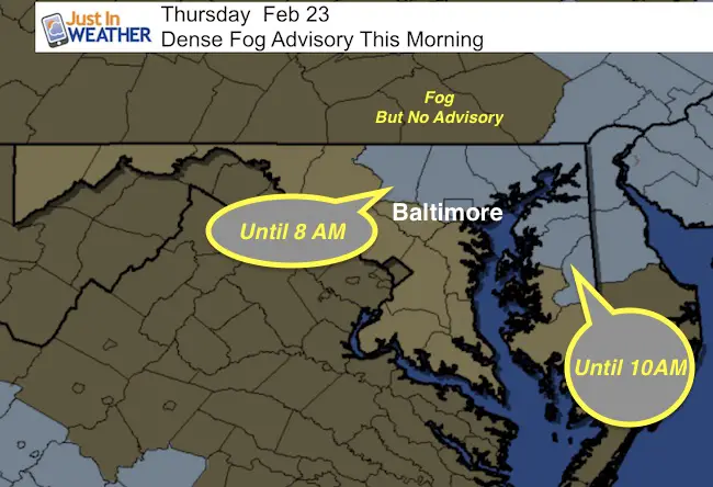
 Thursday Feb 23 – We start this morning with a Dense Fog Advisory in parts of central Maryland. This is issued when visibility is down below 1/4 mile, which can be dangerous for travel. The thickest fog seems to be in central Carroll and into Harford and Cecil County. The Advisory lasts through 8 AM west of the Bay, and 10 AM on the Eastern Shore. There is fog outside of the warming area, such as southern PA that may be thick in spots, if not widespread. Just allow for a slow commute.
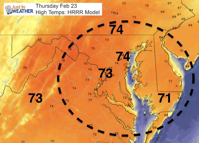
Today the sun will break out and temps will jump into the low and middle 70s. This should fall short of the record of 78°F set in 1874. But a disturbance will set up a line of rain north and west of Baltimore. These areas highlighted in the slider below will show a slow moving, yet moderate line of rain that could be beneficial to some areas. Another push of rain could lead to thunderstorms Saturday afternoon as cold air rushes back in for the end of the weekend. Here’s a look at the maps.
Chance Of Evening Rain
Slider —> Simulated Radar HRRR Model
Chance Of T’Storms Saturday
Slider —> GFS Model
[metaslider id=43602]
Temperature Outlook
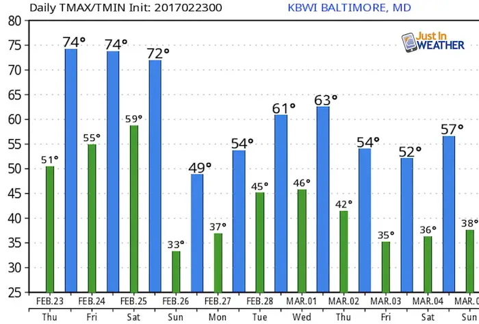
Record Highs On The Calendar This Week
Feb 23 1874: 78°F. *Compare to (Thursday)
Feb 24 1985: 79°F. *Compare to (Friday)
Feb 25 1930: 83°F *Hottest for the month *Compare to (Saturday)
Feb 26 1932*: 74°F Tied the mark set in 1930 *Compare to (Sunday)
 Get the award winning Kid Weather App I made with my oldest son and support our love for science, weather, and technology. Our 3 year anniversary of the release and our contribution to STEM education is this November. It has been downloaded in 60 countries, and works in both temperature scales. With your support we can expand on the fun introduction to science and real weather.
Please share your thoughts, best weather pics/video, or just keep in touch via social media
-
Facebook: Justin Berk, Meteorologist
-
Twitter: @JustinWeather
-
Instagram: justinweather
Faith in the Flakes Online- Flannel PJs Printed Inside Out
Store Now Open

- We’ve added Flannel PJ Pants that will be printed inside out. They have to be, to make it snow ?
- Free Personal Delivery for orders of 20 items or more to schools and businesses.
- Click this image for the online store.
- Look for more items to be added soon.
- Also see the info for the STEM Assembly Spirit Wear program: Put your school name on the shirts and raise money for you PTO/PTA in the process.
Sign up for email updates on new posts
Since you may miss some posts via social media, click here for email alerts as a way to make sure you don’t miss any. *You may have to refresh that page once for your browser to clear out the images.
FITF SNOW STICKS
 Available in 2 Ft, 30 Inches, and 3 Ft Sizes. Also with Orange/Black or Purple/Black. Click on the image to see the options offered by my friend Thatcher at Signs By Tomorrow in Timonium.
Go to http://www.signsbytomorrow.com/timonium/ to order yours today! Click the ‘Request a Quote’ button at the top of the page. In comment box include color, size and payment information. Please indicate whether you’d like to have us UPS ship them to you or if you would like to pick up in our store. Snow Sticks will ship or will be ready for pick up in our store 48 hrs after order is placed, Mon-Fri.
Also See:
My Winter Outlook for 2016-2017: Colder with snow spread out more
NOAA Winter Outlook for 2016 to 2017
La Nina Formed: What it could mean to our winter
Farmers Almanacs Split On Cold And Snow
Extreme Weather of 2015 balanced out on both ends
Low Snow Winters In Baltimore: Records Might Surprise You