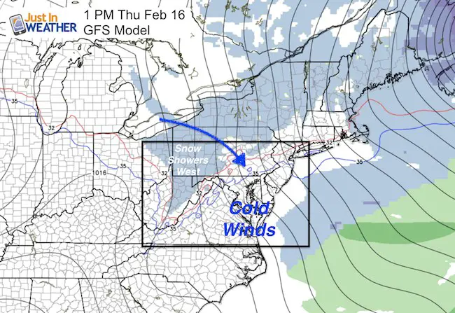
Thursday February 16 – Today will be cold. No doubt about that. Strong winds from the northwest continue to blow in the wake of the storm that just passed us by. Lake Effect snow showers are reaching the mountains of western Maryland and much of our area just gets the chill while remaining dry. Temperatures will reach the mid 30s to near 40°F, but wind chills will remain in the 20s.
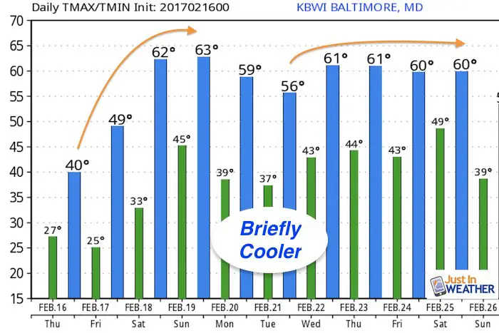
Looking ahead to the holiday weekend and Presidents week, nothing but a warm up. In fact, the upper level air pattern supports spring like weather here in the heart of winter. In fact, the warm up appears to last much of the next week, with a day or two that may be cooler in the middle. Normal High Temperatures now should be 45°F. The outlook shows plenty of 60s. #notmywinter . I should add that there is a chance of rain with that warm air much of the second half of next week.
The short story is, no snow in sight! The insight does lean towards a suggestion that the pattern may cool down as spring begins, so there may be a balance to the mild winter as it ends in March. Spring snow is possible if you have FITF. Stay tuned.
Upper Level Air Pattern —-> slider GFS Model
Temperature Outlook
 Get the award winning Kid Weather App I made with my oldest son and support our love for science, weather, and technology. Our 3 year anniversary of the release and our contribution to STEM education is this November. It has been downloaded in 60 countries, and works in both temperature scales. With your support we can expand on the fun introduction to science and real weather.
Please share your thoughts, best weather pics/video, or just keep in touch via social media
-
Facebook: Justin Berk, Meteorologist
-
Twitter: @JustinWeather
-
Instagram: justinweather
Faith in the Flakes Online- Flannel PJs Printed Inside Out
Store Now Open

- We’ve added Flannel PJ Pants that will be printed inside out. They have to be, to make it snow ?
- Free Personal Delivery for orders of 20 items or more to schools and businesses.
- Click this image for the online store.
- Look for more items to be added soon.
- Also see the info for the STEM Assembly Spirit Wear program: Put your school name on the shirts and raise money for you PTO/PTA in the process.
Sign up for email updates on new posts
Since you may miss some posts via social media, click here for email alerts as a way to make sure you don’t miss any. *You may have to refresh that page once for your browser to clear out the images.
FITF SNOW STICKS
 Available in 2 Ft, 30 Inches, and 3 Ft Sizes. Also with Orange/Black or Purple/Black. Click on the image to see the options offered by my friend Thatcher at Signs By Tomorrow in Timonium.
Go to http://www.signsbytomorrow.com/timonium/ to order yours today! Click the ‘Request a Quote’ button at the top of the page. In comment box include color, size and payment information. Please indicate whether you’d like to have us UPS ship them to you or if you would like to pick up in our store. Snow Sticks will ship or will be ready for pick up in our store 48 hrs after order is placed, Mon-Fri.
Also See:
My Winter Outlook for 2016-2017: Colder with snow spread out more
NOAA Winter Outlook for 2016 to 2017
La Nina Formed: What it could mean to our winter
Farmers Almanacs Split On Cold And Snow
Extreme Weather of 2015 balanced out on both ends
Low Snow Winters In Baltimore: Records Might Surprise You