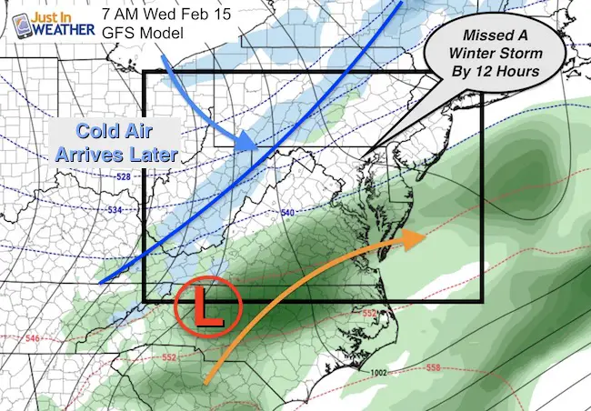
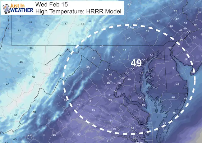
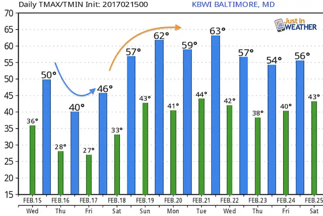
 February 15 – Here is the storm that could have been. Last week there was a day or two when the European Model showed a show event. I did not discuss that, because it did not have support and was not meant to be. The timing of the southern storm and cold air is off by about 12 hour. So today, rain may be heavy in southern Maryland this morning. This afternoon colder air will arrive after the storm moves off of the coast. There may be some flurries or snow showers, mainly in the mountains. Then one chilly day followed by a warm up this weekend. In fact we have about a 5 day period of the Presidents Holiday Weekend that will be in the upper 50s to mid 60s. Early taste of spring.
Is winter done? No. But we are in the 4th quarter and it looks like the next chance for any hint of snow is another week away, and into the end of February. This may be good news for some, but bad for businesses that are based on cold weather.
Simulated Radar —-> slider HRRR Model
High Temperatures
Temperature Outlook
I will have more on the longer range outlook in my evening post.
 Get the award winning Kid Weather App I made with my oldest son and support our love for science, weather, and technology. Our 3 year anniversary of the release and our contribution to STEM education is this November. It has been downloaded in 60 countries, and works in both temperature scales. With your support we can expand on the fun introduction to science and real weather.
Please share your thoughts, best weather pics/video, or just keep in touch via social media
-
Facebook: Justin Berk, Meteorologist
-
Twitter: @JustinWeather
-
Instagram: justinweather
Faith in the Flakes Online- Flannel PJs Printed Inside Out
Store Now Open

- We’ve added Flannel PJ Pants that will be printed inside out. They have to be, to make it snow ?
- Free Personal Delivery for orders of 20 items or more to schools and businesses.
- Click this image for the online store.
- Look for more items to be added soon.
- Also see the info for the STEM Assembly Spirit Wear program: Put your school name on the shirts and raise money for you PTO/PTA in the process.
Sign up for email updates on new posts
Since you may miss some posts via social media, click here for email alerts as a way to make sure you don’t miss any. *You may have to refresh that page once for your browser to clear out the images.
FITF SNOW STICKS
 Available in 2 Ft, 30 Inches, and 3 Ft Sizes. Also with Orange/Black or Purple/Black. Click on the image to see the options offered by my friend Thatcher at Signs By Tomorrow in Timonium.
Go to http://www.signsbytomorrow.com/timonium/ to order yours today! Click the ‘Request a Quote’ button at the top of the page. In comment box include color, size and payment information. Please indicate whether you’d like to have us UPS ship them to you or if you would like to pick up in our store. Snow Sticks will ship or will be ready for pick up in our store 48 hrs after order is placed, Mon-Fri.
Also See:
My Winter Outlook for 2016-2017: Colder with snow spread out more
NOAA Winter Outlook for 2016 to 2017
La Nina Formed: What it could mean to our winter
Farmers Almanacs Split On Cold And Snow
Extreme Weather of 2015 balanced out on both ends
Low Snow Winters In Baltimore: Records Might Surprise You