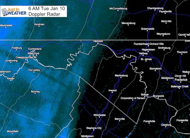
 6:10 AM Tuesday January 10 – The band of snow moving through the mountains is a little stronger and faster than models have suggested. This may be just enough to coat the ground, and considering the morning commute is the main reason for the extra attention. My prior radar simulation is posted again below, but please consider the error of at lest 1 hour faster… plus the band holding together a little longer. The timing I suggested did account for the faster speed. Just wanted to remind you so you are not surprised.
 A transition is about to occur in the atmosphere as the arctic air will move out and a warm up will begin today. With that is a band of snow and sleet that is moving through this morning. The problem is that it has to cross the mountains and bump into very dry air overhead. It is hard to consider that this solid band of precipitation will fall apart, but that is what typically happens. The hardest question to answer is where and when. So timing this out is tough. Here is the latest radar simulation from the High Resolution model showing the progress that reaches central Maryland at the tail end of the morning commute. At this point busses and most commuters shoal be OK, but west of Frederick this may clip you.
Notes:
- Temps will be cold enough so that what falls will stick.
- There is also a lot of salt on the roads to help with the onset.
- This will last about an hour when it passes by.
- Sleet may mix in where green shading shows up on the radar simulation
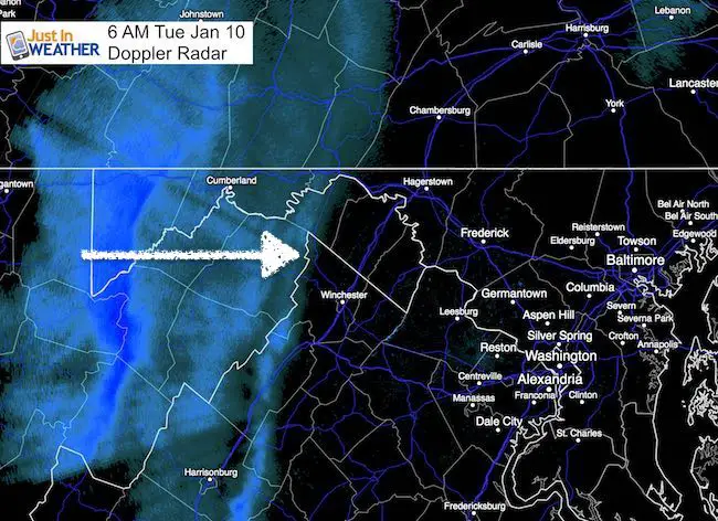
- Notice the band falling apart! The best chance to get snow and sleet will be west of I-81 until 8 AM. This includes 6:30 AM to 8 AM arrival in Hagerstown and Winchester.
- Along I-70 east of Frederick after 8 AM.
- Around Baltimore, at this point… looks like it will arrive after 9 AM.
- Temperatures will rise above freezing this afternoon.
Radar Simulation —> slider HRRR Model
Temperatures:


Stay tuned for more updates
Faith in the Flakes Online- Flannel PJs Printed Inside Out
Store Now Open

- We’ve added Flannel PJ Pants that will be printed inside out. They have to be, to make it snow ?
- Free Personal Delivery for orders of 20 items or more to schools and businesses.
- Click this image for the online store.
- Look for more items to be added soon.
- Also see the info for the STEM Assembly Spirit Wear program: Put your school name on the shirts and raise money for you PTO/PTA in the process.
FITF SNOW STICKS
 Available in 2 Ft, 30 Inches, and 3 Ft Sizes. Also with Orange/Black or Purple/Black. Click on the image to see the options offered by my friend Thatcher at Signs By Tomorrow in Timonium.
Go to http://www.signsbytomorrow.com/timonium/ to order yours today! Click the ‘Request a Quote’ button at the top of the page. In comment box include color, size and payment information. Please indicate whether you’d like to have us UPS ship them to you or if you would like to pick up in our store. Snow Sticks will ship or will be ready for pick up in our store 48 hrs after order is placed, Mon-Fri.
Please share your thoughts, best weather pics/video, or just keep in touch via social media
- Facebook: Justin Berk, Meteorologist
- Twitter: @JustinWeather
- Instagram: justinweather
 Get the award winning Kid Weather App I made with my oldest son and support our love for science, weather, and technology. Our 3 year anniversary of the release and our contribution to STEM education is this November. It has been downloaded in 60 countries, and works in both temperature scales. With your support we can expand on the fun introduction to science and real weather.
Sign up for email updates on new posts
Since you may miss some posts via social media, click here for email alerts as a way to make sure you don’t miss any. *You may have to refresh that page once for your browser to clear out the images.
Also See:
My Winter Outlook for 2016-2017: Colder with snow spread out more
NOAA Winter Outlook for 2016 to 2017
La Nina Formed: What it could mean to our winter
Farmers Almanacs Split On Cold And Snow
Extreme Weather of 2015 balanced out on both ends
Low Snow Winters In Baltimore: Records Might Surprise You