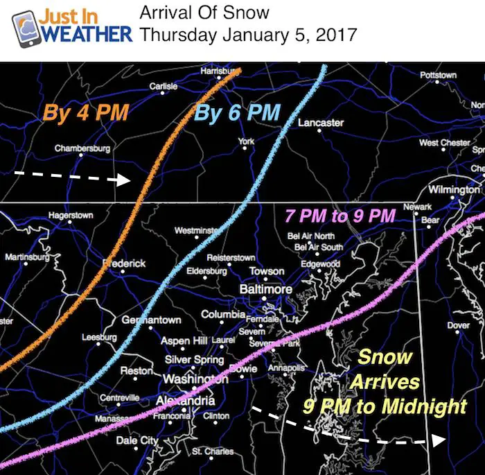
 Thursday January 5 – Our first impact snow event of the season will being this evening. The faster arrival means that it may impact some after school activities, but also will depart sooner. It also means more stickage overnight, and may suggest a faster time and shift north with the next system to follow. More on that below. By the time you wake up Friday morning the snow will be done, however there could be some impact on the traveling and perhaps school delays. I say perhaps because that all depends on how your local road crews handle this event. West of the mountains will have snow falling before sunset. There may be flakes reaching Germantown, Mount Airy, Westminster, and York PA by 6 PM. It may appear to be stuck in the mountains for a few hours, then progress through metro Baltimore and into Philadelphia by 9 PM. Most of Maryland should have snow, including St. Mary’s and Ocean City by midnight.
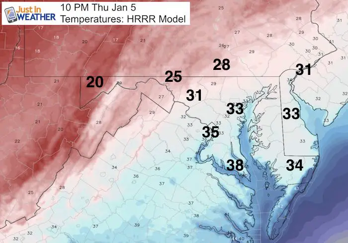
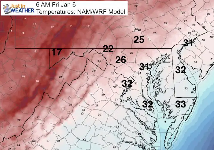
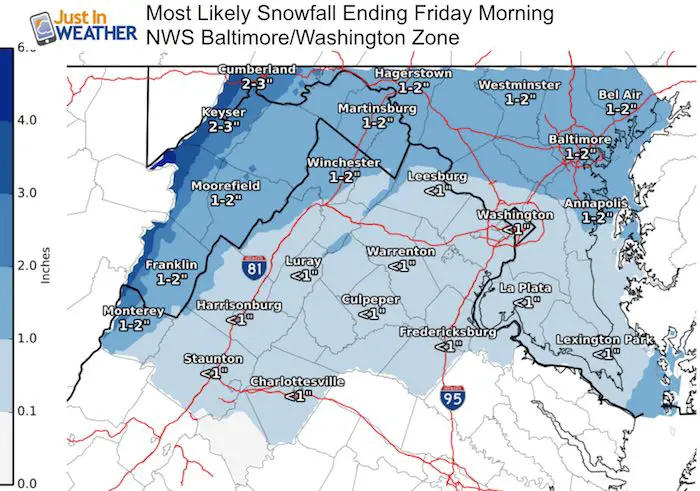
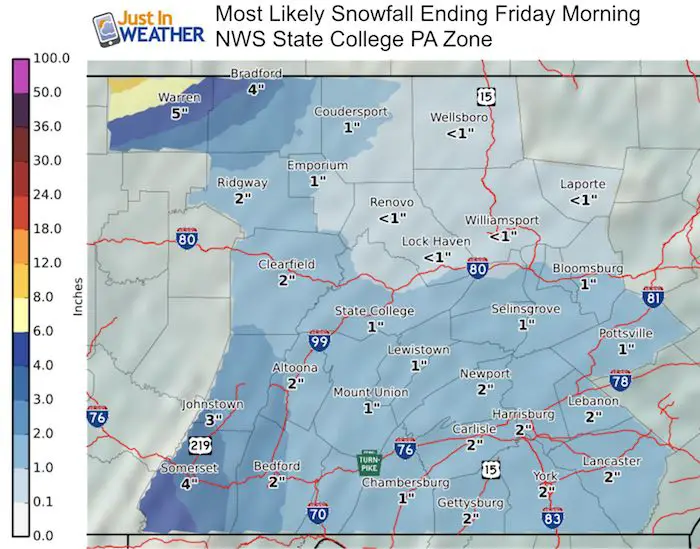
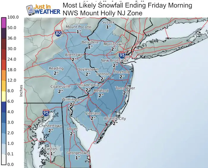
Here is the radar simulation and more notes to follow. I expect The National Weather Service will issue Winter Weather Advisories as we will average between 1 and 2 inches of snow. I am not making a map since it will be widespread with local variations and I agree with the NWS maps shown below. But will point out the temperatures that will make this more fluffy Northwest of Baltimore. Near central Maryland and east, temps may start above freezing and end below, so ice may develop at the road surface adding to the challenge for road crews.
Radar Simulation —> HRRR Model
Snow Departs Before Sunrise

Storm Departing By Daybreak:

Temperatures:
This Evening
Friday Morning
Snowfall Potential: Widespread 1 to 2 Inches
NWS Zone Maps – (see the more on the Saturday Storm Below)
Faith in the Flakes Online- Flannel PJs Printed Inside Out
Store Now Open

- We’ve added Flannel PJ Pants that will be printed inside out. They have to be, to make it snow ?
- Free Personal Delivery for orders of 20 items or more to schools and businesses.
- Click this image for the online store.
- Look for more items to be added soon.
- Also see the info for the STEM Assembly Spirit Wear program: Put your school name on the shirts and raise money for you PTO/PTA in the process.
FITF SNOW STICKS
 Available in 2 Ft, 30 Inches, and 3 Ft Sizes. Also with Orange/Black or Purple/Black. Click on the image to see the options offered by my friend Thatcher at Signs By Tomorrow in Timonium.
Go to http://www.signsbytomorrow.com/timonium/ to order yours today! Click the ‘Request a Quote’ button at the top of the page. In comment box include color, size and payment information. Please indicate whether you’d like to have us UPS ship them to you or if you would like to pick up in our store. Snow Sticks will ship or will be ready for pick up in our store 48 hrs after order is placed, Mon-Fri.
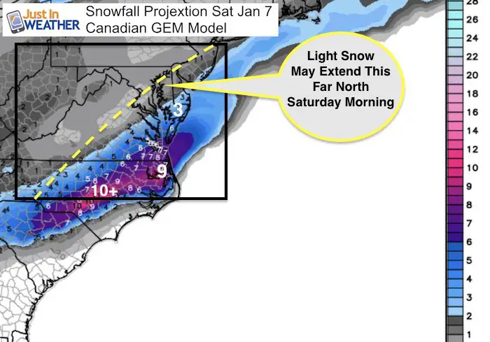
Saturday Storm
As I mentioned earlier, the timing of the energy will determine the development of the next storm. Staying on this earlier trend, the jet stream will not be was far south, and there is more energy aloft to help pull the storm closer… but not close enough for all. This looks like a Delmarva impact storm Saturday morning. I have added a yellow line to where I see the edge of the light snow to fall near Baltimore. Below are the snow totals showing Salisbury with 3″, but much more from Virginia Beach to eastern North Carolina.
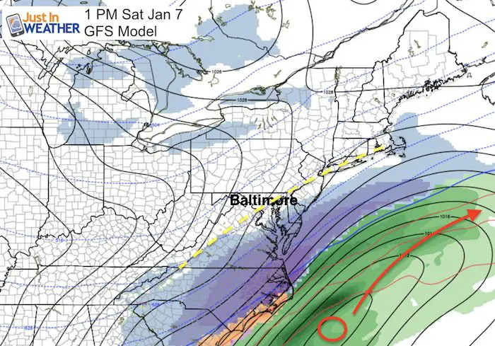
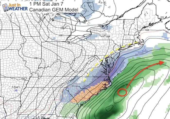
Northern edge of snow Saturday morning may reach I-95, or close… but the accumulation would be an impact for southern Maryland into Richmond and Virginia Beach VA and eastern North Carolina.
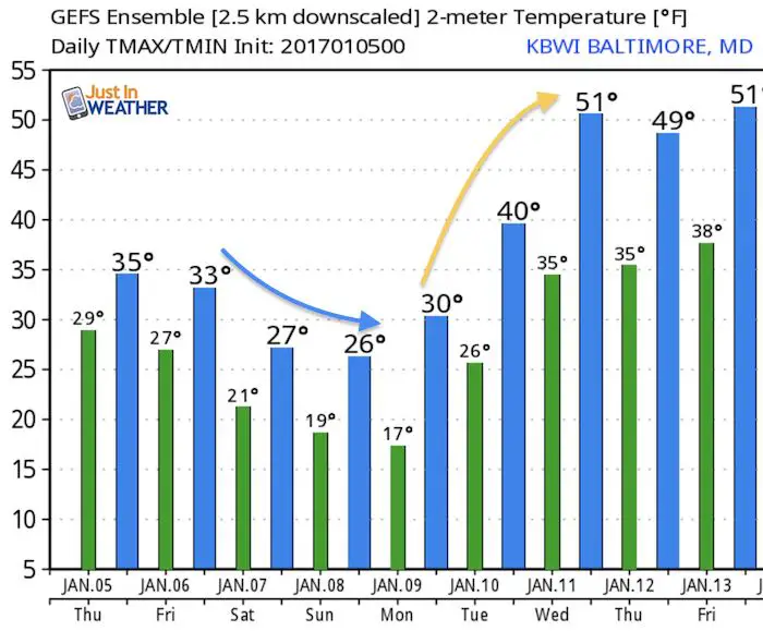
Temperature Outlook
After a cold weekend, the jet stream bounces back north and next week will be warmer. Winter will follow behind it. There is plenty of time left and this system will put us ahead of last winter.
Please share your thoughts, best weather pics/video, or just keep in touch via social media
- Facebook: Justin Berk, Meteorologist
- Twitter: @JustinWeather
- Instagram: justinweather
 Get the award winning Kid Weather App I made with my oldest son and support our love for science, weather, and technology. Our 3 year anniversary of the release and our contribution to STEM education is this November. It has been downloaded in 60 countries, and works in both temperature scales. With your support we can expand on the fun introduction to science and real weather.
Sign up for email updates on new posts
Since you may miss some posts via social media, click here for email alerts as a way to make sure you don’t miss any. *You may have to refresh that page once for your browser to clear out the images.
Also See:
My Winter Outlook for 2016-2017: Colder with snow spread out more
NOAA Winter Outlook for 2016 to 2017
La Nina Formed: What it could mean to our winter
Farmers Almanacs Split On Cold And Snow
Extreme Weather of 2015 balanced out on both ends
Low Snow Winters In Baltimore: Records Might Surprise You