Sunday January 1 2017 – The active weather pattern continues this first week of the new year. But as climatology would have it, colder air will be progressing in during the week.
Update- Freezing Rain Advisory expanded into northern Maryland
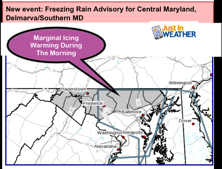
The first event will bring mostly rain, but there is a small chance of minor icing Monday morning north and west of Baltimore inland from the Bay. A Freezing Rain Advisory is in place (see my prior post). Not all models agree, as the HRRR radar simulation below shows all rain, even on the north end as it arrives between 2 and 4 AM. Rain will be with us most of the day, then a break Monday night, then another round of rain Tuesday.
When this storm moves out, it will help push the jet stream farther south. The fast moving systems to follow will bring a chance for light snow Thursday evening into Friday. The weekend event is still in question as the energy may move farther off of the coast. I discussed the model error tendency for long range winter systems yesterday. FITF
Here’s a quick look at what we will be following…..
Radar Simulation —> slider
There may be a break around Baltimore, but rain should remain steady near Annapolis to the Eastern Shore all day.
Storm Track Part 1 —> slider
[metaslider id=41888]
Storm Track Part 2 —> slider
[metaslider id=41900]Sign up for email updates on new posts
Since you may miss some posts via social media, click here for email alerts as a way to make sure you don’t miss any. *You may have to refresh that page once for your browser to clear out the images.
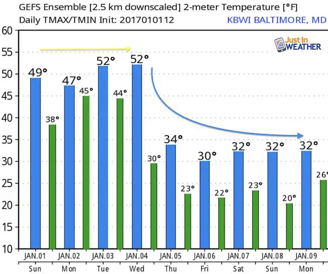
Temperature Outlook
Faith in the Flakes Online- Flannel PJs Printed Inside Out
Store Now Open

- We’ve added Flannel PJ Pants that will be printed inside out. They have to be, to make it snow ?
- Free Personal Delivery for orders of 20 items or more to schools and businesses.
- Click this image for the online store.
- Look for more items to be added soon.
- Also see the info for the STEM Assembly Spirit Wear program: Put your school name on the shirts and raise money for you PTO/PTA in the process.
FITF SNOW STICKS
 Available in 2 Ft, 30 Inches, and 3 Ft Sizes. Also with Orange/Black or Purple/Black. Click on the image to see the options offered by my friend Thatcher at Signs By Tomorrow in Timonium.
Go to http://www.signsbytomorrow.com/timonium/ to order yours today! Click the ‘Request a Quote’ button at the top of the page. In comment box include color, size and payment information. Please indicate whether you’d like to have us UPS ship them to you or if you would like to pick up in our store. Snow Sticks will ship or will be ready for pick up in our store 48 hrs after order is placed, Mon-Fri.
Please share your thoughts, best weather pics/video, or just keep in touch via social media
- Facebook: Justin Berk, Meteorologist
- Twitter: @JustinWeather
- Instagram: justinweather
 Get the award winning Kid Weather App I made with my oldest son and support our love for science, weather, and technology. Our 3 year anniversary of the release and our contribution to STEM education is this November. It has been downloaded in 60 countries, and works in both temperature scales. With your support we can expand on the fun introduction to science and real weather.
Also See:
My Winter Outlook for 2016-2017: Colder with snow spread out more
NOAA Winter Outlook for 2016 to 2017
La Nina Formed: What it could mean to our winter
Farmers Almanacs Split On Cold And Snow
Extreme Weather of 2015 balanced out on both ends
Low Snow Winters In Baltimore: Records Might Surprise You
NOAA Ranks Blizzard 2016 4th Worst Snowstorm On Record
Blizzard 2016 Record Top Snowstorm: Area Totals