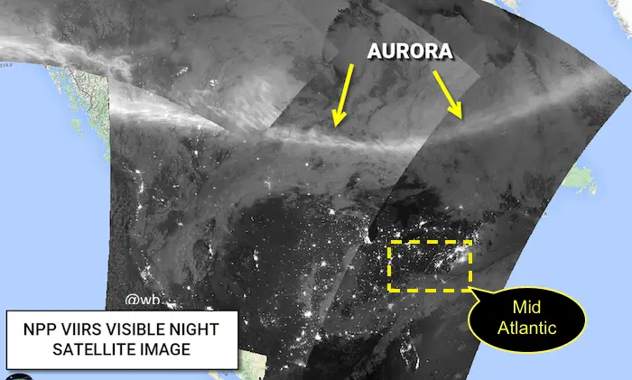
The alert for the solar storm and high aurora activity had many in the US excited for possible viewing last night (November 3). The planetary K Index of 5 or higher meant a better then normal chance to see the Northern Lights farther south.  This top image is from the NPP Satellite and compiled by my friend @wxbrad showing the display last night was locked up deep into Canada and northern Europe, but there were spots in Wisconsin and Minnesota that were captured in photos. I’ve shared a few below.
Despite the mild temperatures and clear skies here in the Mid Atlantic, it did not work out for us. But the storm is still raging this morning as seen in this update from NOAA’s Space Weather Prediction Center. Viewing still might be possible tonight. However, it did happen and some shared their awesome photos online. Below is a collection of the aurora seen this week.
Wisconsin
Bemiji, Wisconsin. Credit and follow Jacob Laducer on Facebook
Minnesota
Eagle River. From Scott Pearson
From Sweden:
Mia Stålnacke is a self proclaimed space and science geek as well as an accomplished photographer who captured this stunning image. Follow her on twitter @AngryTheInch
Related Links
Solar Storm: St. Patrick’s Day Green Aurora Seen By NASA May Reach Mid Atlantic
Epic Video From Feb 2014 Event
Please share your thoughts, best weather pics/video, or just keep in touch via social media
- Facebook: Justin Berk, Meteorologist
- Twitter: @JustinWeather
- Instagram: justinweather
 Get the award winning Kid Weather App I made with my oldest son and support our love for science, weather, and technology. Our 3 year anniversary of the release and our contribution to STEM education is this November. It has been downloaded in 60 countries, and works in both temperature scales. With your support we can expand on the fun introduction to science and real weather.[/fusion_builder_column][/fusion_builder_row][/fusion_builder_container]


